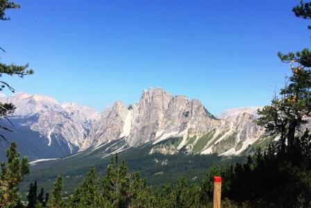
 Le gite qui proposte sono di diverso livello ma, essendo passeggiate su sentiero, sono alla portata di tutti, pur se necessitano di attenzione in qualche caso. La zona interessata è il bosco del Faloria, con Mandres e Baita Fraina; la salita verso la cima del Faloria e diverse modalità di ascesa e di discesa; le gite dal Faloria al Sorapiss.
The trips offered here are of different levels but, being walking on the path, are available to everyone, even if they need attention in some cases . The affected area is the forest of Faloria, with Mandres and Baita Fraina. The climb to the top of the Faloria and different modes of ascent and descent; trips from the Faloria Sorapiss .
§ § §
Area: Faloria – Mandres / Baita Fraina (1/2 giornata) [gite bambinabili /per tutti]
Percorso: Salita nei boschi da Liceo Orsoline (m. 1305 slm):
a) a Mandres (m. 1480 slm; sent. 210; 30-45 min.) e ritorno;
b) non necessariamente si deve raggiungere Mandres; ben si può camminare nel bosco finchè se ne ha voglia;
c) a Mandres (sent. 210; 45 min.; 150 m. di dislivello) – proseguire il sent. 210 verso i laghi di Costalares (ormai asciutti), fino al lago Scin (1,5 h);
d) nella salita verso Mandres, (o una volta giunti a Mandres, scendendo leggermente) si prende sulla destra il sent. 220, si che in quota nel bosco giunge fino a Baita Fraina (m. 1304 slm; 45 min.-1 h) e rit. (totali 2h);
e) a Baita Fraina si può giungere anche con la strada della ferrovia, prendendo al relativo bivio la strada (1 h);
f) nella salita verso Mandres prendendo sulla destra il sent. 220 per eventuale ricerca della Porta del dio Silvano (45 min.);
Valutazioni: Per chi ha bisogno di un bel bosco tranquillo, splendido, solitario e misterioso – con bimbi anche piccoli (4 anni) in cerca di animali (ho visto negli anni cervi, caprioli, lepri, picchio all’opera, un tempo in un luogo deruto anche salamandre); un tempo si trovavano facilmente anche mirtilli e fragole – [effettuata nelle sue varianti quasi ogni anno; 18.8.83; 7.7.95; 15.8.98; 17.8.00; 13.8.01; 15.8.03; 23.7.06; 19.7 e 20.8.08; 6.8.09; 6.8.10; 9 e 15.8.19; 8.8.23; 17.8.25].
Animali: emozione grandissima nel 2006 per un cervo maschio adulto che, forse spaventato, ha attraversato il sentiero letteralmente sorvolando le nostre teste – visti negli anni cervi, caprioli, lepri, picchio all’opera, un tempo in un luogo deruto anche salamandre; scoiattoli, ghiro, volpi.
Area: Faloria – Mandres / Hut Fraina ( 1/2 day ) [ trips bambinabili / all ]
Run: Rise in the woods by the Ursuline High School: a) Mandres (path. 210; 45 min) and back ; b) does not necessarily have to reach Mandres; well you can walk in the woods until you feel like it; c) Mandres (path. n. 210; 45 min; 150 m. in altitude) – continue the felt n. 210 to the lakes of Costalares, to Lake Scin ( 1.5 h); d ) in the ascent to Mandres, taking the right path n. 220, you come up to Baita Fraina (1 h) and return; e) to Baita Fraina you can also reach the railway road, taking the road to its junction (2 h) ; f ) in the ascent to Mandres taking the right path n. 220 for any search of the Gate of god Silvanus (45 min);
Ratings: For those who need a nice quiet forest , beautiful , lonely and mysterious – even with small children (4 years ) in search of animals , blueberries and strawberries – [performed in its variants almost every year ; 18/08/83 ; 07/07/95 ; 19.7 and 08.20.08 ; 15/08/98 ; 17/08/00 ; 13/08/01 ; 15/08/03 ; 07/23/06 ; 06/08/09 ; 6.8.10; 9 e 15.8.19] . Pets: huge emotion in 2006 for an adult male deer , perhaps frightened , crossed the path literally flying over our heads – often seen squirrels – dormouse – hare – foxes
° ° °
Area: Faloria/Pomagagnon – Mandres / Mietres [intera giornata -per tutti whole day -for all]
Percorso: Dal Liceo delle Orsoline a Mandres (sent. 210; 45 min.; 150 m. di dislivello) – poco prima di Mandres al bivio prendere il sent. 206 che sale (200 m. di dislivello) e giunge sulla strada per Passo Tre Croci – attraversata la strada per sent. 206 si giunge a Malga Lareto e quindi per sent. 211 a Mietres – (3/3,5 h)
Valutazione: Bella gita tutta nei boschi, poco frequentata specie nella parte centrale (effettuata 4.8.86; 5.8.89]
Route: From High School Ursuline Mandres (path n. 210; 45 min; 150 m in altitude) – just before the junction Mandres take the felt . 206 rising (200 m in altitude) and comes on the road to Passo Tre Croci – across the street to path n. 206 leads to Malga Lareto and then path n. 211 to Mietres – ( 3 / 3,5 h )
Rating: Nice walk across the woods, little-used species in the central part (carried 04/08/86 ; 05/08/89 ]
° ° °
Area: Faloria – (1/2 giornata – per tutti) 1/2 day – for everyone
Percorso: Salita nei boschi da Baita Fraina (sent. 220), seguendo tracce di sentiero indicate, al bivio del sent. 20, come “sorgente”; superata una zona umida, si sale fino alla cresta, sopra alla Porta del dio Silvano (1,30 h + 30 min.).
Valutazioni: Passeggiata in salita, piuttosto fine a se stessa, con molta attenzione da prestare in cresta, esposta e pericolosa. Non frequentata [effettuata 26.8.08].
Route: Rise in the woods from Baita Fraina (path n. 220), following traces of the path indicated, at the junction of the felt n. 20, as a ” source “; exceeded a wetland, climb up to the ridge, above the door of the god Silvanus (1.30 h + 30 min)
Ratings: Walk uphill, rather an end in itself, with much attention to be paid to the ridge, exposed and dangerous. Unfrequented [ carried 08/26/08 ]
§ § §
Area: al Faloria
A) Direttissima (1/2 giornata – due ore di cammino)
Percorso: Salita nei boschi da Liceo Orsoline, verso Mandres (sent. 210); poco sopra si prende sent. 212 sulla destra in una salita scoscesa fino al Rif. Faloria (800 m. dislivello in salita; 1,5/2 h).
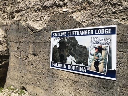
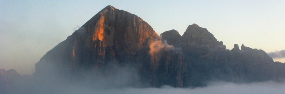
Naturalmente il sentiero può essere anche percorso in discesa (1,5 h): dal Rif. Faloria (m. 2.123 s.l.m.) un sentiero sulla destra porta ai ripidi verdi, nei pressi della vecchia costruzione recentemente utilizzata quale base operativa nel film di Stallone, Cliffhanger. Da qui discesa diretta, prima su ghiaie, poi tra i mughi, poi nel bosco (bivio poco prima di Mandres (m. 1.480 s.l.m.), fino al Liceo Orsoline (m. 1.300 s.l.m.).
Valutazioni: Dopo Mandres salita scoscesa tra mughi e rocce. Bisogna avere piede fermo; panorama splendido sulla valle d’Ampezzo. Si fanno certamente gambe per salita e discesa. Il bosco del Faloria è sempre speciale ed in quella parte poco frequentato [effettuata 11.8.81; 1.8.82; in discesa, in combinata con il sentiero Dolomieu, 24.8.17, nel bosco visto un giovane cervo]
B) Dolomieu – panoramic trail (1/2 giornata – 1,5/2 h di cammino; per tutti)
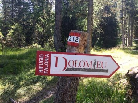
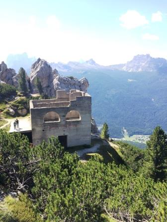
Percorso: si giunge a Rio Gere (m. 1.698 s.l.m.), presso la partenza della seggiovia che in inverno porta (in tre tratte) al Rif. Faloria; nel piazzale si lascia l’auto. Si sale per il sent. 212, inizialmente su carrozzabile (attenzione alle bici!), poi nel bosco; il sentiero sale non sempre comodamente, ma con affacci splendidi, accessibili e da tutti fruibili, sulla valle d’Ampezzo. Si giunge al Rif. Faloria (m. 2.123 s.l.m.). (1,5 h) – Discesa per lo stesso sentiero ovvero attraverso la “direttissima” sopra descritta (ma l’automobile va recuperata comunque a Rio Gere…).
Valutazioni: l’accessibilità e la panoramicità valgono la passeggiata [effettuata il 24.8.17, in combinata con la Direttissima].
A) Direct (1/2 day – two hours walk) Route: Up the woods from Liceo Orsoline to Mandres (210); Just over it gets sent. 212 on the right in a steep climb up to Rif. Faloria (800 m uphill climb, 1.5 / 2 h). – Of course, the trail can also be downhill (1,5 h): from Faloria (2,123 m), a path to the right leads to the steep green, near the old building recently used as a base in the Stallone film, Cliffhanger. From here, direct descent, first on gravel, then between the mughi, then into the woods (junction shortly before Mandres (1,480 m), to Liceo Orsoline (m 1,300 m).
Reviews: After Mandres climbs steeply between mounds and rocks. You have to have a firm foot; Beautiful scenery on the Ampezzo valley. It certainly makes legs uphill and downhill. The wood of the Faloria is always special and in that little-frequented part [performed on 11.8.81; 08/01/82; Downhill, in conjunction with the Dolomieu trail, 24.8.17, in the woods seen a young deer] B) Dolomieu – panoramic trail (1/2 day – 1,5 / 2 h walk, for all) Path: you arrive at Rio Gere (1,698 m), at the departure of the chair lift that in winter brings (in three tracks) to Rif. Faloria; In the square you leave your car. Get up for the sent. 212, initially on a carriage (pay attention to bikes!), Then into the woods; The trail does not always come up comfortably, but with beautiful views, accessible and accessible to everyone, on the Ampezzo valley. You reach the Rif. Faloria (2,123 m). (1.5 h) – Downhill for the same trail or through the “very dirty” above (but the car must be recovered in Rio Gere …).
Ratings: accessibility and panoramic are worth the walk [performed on 24.8.17, in conjunction with the Direttissima].
§ § §
Area Faloria – Rio Gere – al Forte di sbarramento (=bunker) sopra passo Tre Croci (30 min. nel bosco, per tutti);
-Lasciando l’automobile al parcheggio di Rio Gere – partenza seggiovia per il Faloria (m. 1698 slm), si sale (sotto la seggiovia) sul sentiero 212 (inverno pista da sci) e si prosegue per circa 200 metri; – sulla sinistra, con una curva quasi a gomito, si prenda un sentiero non segnato ma perfettamente visibile (che si rivela strada militare), che sale nel bosco; – dopo circa dieci minuti di salita il sentiero prosegue in piano; – dopo circa altri dieci minuti sulla sinistra si prenda un ulteriore sentiero (anch’esso che sembra tornare indietro, quasi a gomito) che termina vicino ad un grande bunker (m. 1855 slm), che era uno dei due Forti di sbarramento italiani che controllavano i due lati di Passo Tre Croci. – ritorno per lo stesso sentiero.
Valutazioni: Interessante da vedere per l’ampiezza e l’imponenza il bunker è ormai coperto da vegetazione. Possibile pic nic piacevole nel bosco e con pochissime persone che si incontrano; per tutti ma servono panini ed acqua (22.8.21).
Faloria area – Rio Gere – at the barrage fort (= bunker) above the Tre Croci pass (30 min. In the woods, for everyone); – Leaving the car at the Rio Gere car park – chairlift departure for Faloria (1698 m asl), go up (under the chairlift) on path 212 (winter ski slope) and continue for about 200 meters; – on the left, with an almost sharp bend, take a path that is not perfectly visible (which turns out to be a military road), which climbs into the woods; – after about ten minutes of climbing the path continues on level ground; – after about another ten minutes on the left take a further one (which also seems to turn back, almost at an angle) which ends near a large bunker (1855 m asl), which was one of the two Italian barrage forts that controlled the two sides of Passo Tre Croci. – return by the same path.
Evaluations: Interesting to see for its size and grandeur, the bunker is now covered with vegetation. Possible pleasant picnic in the woods and with very few people who meet; for everyone but they need sandwiches and water (22.8.21)
§§§
Area: Faloria – Val Orita (intera giornata – per tutti – tre/quattro ore di cammino)
full day – for all – three / four hours of walking
Percorso: dal Rif. Faloria (m. 2123 s.l.m., cui si arriva o in funivia o salendo per il Dolomieu o la direttissima) si prosegue verso i Tondi di Faloria seguendo la pista dello skilift (sent. 213). Si giunge, prima della forcella Faloria e dunque ben prima dei Tondi, con una breve e visibile deviazione sulla destra, ai ripetitori delle telecomunicazioni (m. 2230 s.l.m.; 20 min.). E’ questo il sent. 214 (parte dell’Alta Via n. 3) che si segue e scende dal Faloria per la Val Orita; prima in modo più dolce tra mughi, poi più fortemente anche con sentiero ghiaioso e sassoso, aggirando gli ultimi contrafforti del Faloria per poi (sopra Zuel) girare verso destra; il sentiero prosegue in lieve discesa trasversale (sopra al bosco di Mondeserto) fino a lasciare i mughi e giungere ad un bosco ed alla Fonte (a ca. 1380 m. slm e dunque dopo essere scesi di circa 900 m. (2 h). Si prosegue per sentiero facile in bosco e, alla camionabile, si prende sulla destra in direzione Baita Fraina, dove si arriva dopo 20 min. (1304 slm).
Valutazione una gita non frequentata, con una forte discesa in una stretta valle, sostanzialmente un ghiaione con mughi; occorre avere buone ginocchia e piede fermo … ma si è compensati dal silenzio e dal panorama. La valle è zona fossilifera da ammirare, come gli animali che si possono incontrare (specie camosci) – I rifugi sono in partenza ed in arrivo; non c’è però acqua durante il percorso [effettuata 11.8.89 e il 24.8.22]
Route:from Rif. Faloria (m. 2123 s.l.m., which can be reached either by cable car or by going up to the Dolomieu or the direct route) continue towards the Tondi di Faloria following the ski lift track (sent. 213). Before the Faloria fork and therefore well before the Tondi, with a short and visible detour to the right, you reach the telecommunications repeaters (2230 m asl; 20 min.). This is sentiment. 214 (part of the Alta Via n. 3) which you follow and descend from Faloria to Val Orita; first in a more gentle way among pines, then more strongly also with gravel and stony path, bypassing the last buttresses of Faloria and then (above Zuel) turn right; the path continues slightly downhill (above the Mondeserto wood) until it leaves the pines and reaches a wood and the Fonte (at about 1380 m asl and therefore after having descended about 900 m. (2 h). Continue along an easy path in the woods and, at the lorry road, turn right towards Baita Fraina, where you arrive after 20 minutes (1304 above sea level).
Rating an uncrowded excursion, with a steep descent into a narrow valley, essentially a scree with mountain pines; you need to have good knees and a steady foot … but you are compensated by the silence and the view. The valley is a fossil-bearing area to admire, as are the animals that can be encountered (especially chamois) – The refuges are in departure and arrival; however there is no water during the course [carried out on 11.8.89 and on 24.8.22]
§ § §
Area: Faloria / Sorapiss – Rif. Vandelli (intera giornata – sei/sette ore di cammino) Full day – six / seven hours walk
Percorso:: Salita con mezzi fino a Tondi di Faloria, prendendo la funivia del Faloria nei due tratti (volendo il tragitto si può fare a piedi, e può essere anche una soluzione per una piccola gita panoramica da finire appunto ai Tondi; si sale però sulla pista da sci ed oggi non è più bello come un tempo) – Forcella Faloria (sent. 223; 200 m. di dislivello) –
a questo punto la soluzioni possono essere due:
– 1°: alla Forcella, si tiene la sinistra e si prosegue con il sent. 223 e, in quota, si giunge al Cadin Del Laudo – con il sent. 216 si effettua la discesa al Rifugio Vandelli (250 m. di dislivello in discesa), per gustare il bel lago;
– 2°: lasciare il sent. 223 e prendere quello di destra n. 215 – proseguire nell’anfiteatro fino a Sella Punta Nera (sent. 215; m. 300 di dislivello finale; 1,30 h; effettuata sin qui 16.8.85, e tornati al Rif. Faloria) – il sentiero prosegue superata la Sella in discesa, anche con ghiaione (2 h), e quindi verso il lago di Sorapiss (sent. 215 variante A.V.n. 3; 400 m. di dislivello in discesa; 2 h) fino al Rif. Vandelli;
Dal Rifugio Vandelli si scende al Passo Tre Croci (sent. 215; 150 m. di dislivello; 2,15 h).
Valutazioni: Gita lunga, bella, impegnativa fisicamente (specie nella 2° opzione), e con qualche difficoltà di percorso
–nella 1° opzione: si rimane in quota con una bella vista sulla valle, proprio sotto la cresta – all’inizio della discesa sul Cadin, vi è un breve tratto attrezzato e poi una forte discesa verso il Rifugio [effettuata 9.8.86].
– nella 2° opzione: la salita, su ghiaione spettacolare, è comunque pesantina; ad essa, dopo la Sella segue discesa, sdrucciolevole, non semplice e con alcuni tratti di sentiero attrezzato; segue poi un ghiaione che si può prendere per tagliare il sentiero; poi la discesa per il Rifugio piuttosto lunga; nel 2007 il sentiero era franato e fino al lago il camminare è stato difficile, duro, più lungo del previsto. [effettuate 17.8.93; 5.8.07].
-La discesa al Passo è lunga (analoga per le due soluzioni), panoramica, con una parte attrezzata con gradoni e con due passaggi un po’ esposti, aiutati da corda; termina nel bosco a Tre Croci.
Path: Ascent means up to Faloria Tondi, taking the cable car of Faloria in two sections (wanting the trip can be done on foot, and can also be a solution for a small panoramic tour to end precisely at Tondi; climb though on the ski slope, and today is no longer as nice a time ) – Fork Faloria (sent. 223 ; 200 m . in altitude ) – at this point the solutions may be two : – 1st: the fork , keep left and continue with path n. 223 and, at high altitude, you reach the Cadin Del Laudo – with path n. 216 you make the descent to Rifugio Vandelli (250 m. of descent), to enjoy the beautiful lake; – 2nd: leave path n. 223 and take the right one n. 215 – continue in the amphitheater to Sella Punta Nera (path n. 215; m in altitude 300 final; 1.30 h (done so far 08/16/85, and returned to the ref . Faloria)- the trail continues past the saddle downhill, even with scree (2 h), and then to Lake Sorapiss (path n. 215 variant AVN 3 ; 400 m. of descent; 2 h ) up to Ref . Vandelli – From the Rifugio Vandelli descend to Passo Tre Croci (sent. 215 ; 150 m. in altitude; 2.15 h)
Ratings: Long walk , beautiful , physically demanding (especially in the 2nd option ) , and with some difficulty path -in the 1st option: it remains in proportion with a beautiful view of the valley, just below the crest – the beginning of the descent on Cadin, there is a short stretch equipped and then a sharp descent to the Refuge [carried 08/09/86 ]. – In the 2nd option: the ascent on scree spectacular, is nonetheless hard; to it, after the Sella follows descent, slippery, not simple, with some sections of trail with facilities; then follows a scree which you can take to cut the trail; then the descent to the Refuge rather long; in 2007 the trail was collapsed and the walk down to the lake has been difficult, hard, longer than expected. [ 17/08/93 performed; 08/05/07 ] . -The Descent to Passo is long (similar to the two solutions), overview, with a part equipped with steps and two steps a little exposed, aided by rope; ends in the woods Three Crosses