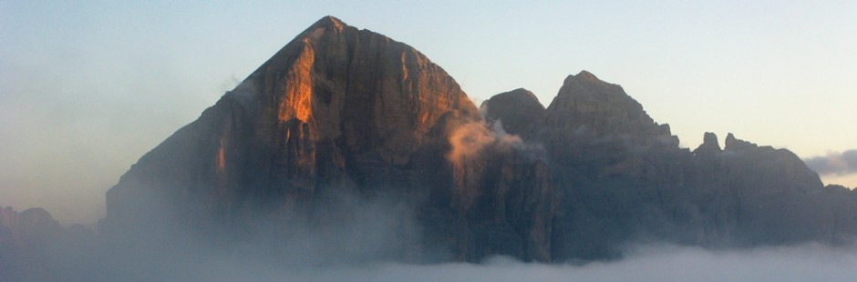
 Il Nuvolau e le Cinque Torri rappresentano uno dei simboli montani della Valle d’Ampezzo e ci si può facilmente accedere.
Al Nuvolau, come all’Averau, si accede anche con via ferrata.
")
La collocazione geografica impone delle connessioni strette con il Passo Giau, con cui è collegato con una serie di gite.

Among the mountains in the Ampezzo Valley Nuvolau and Cinque Torri are emblematic and it is easy to get there. The access to Nuvolau, as to Averau, is by via ferrata. Because of its geographical location it is closely connected to the Giau Pass, with which it is linked througha number of excursions.
Area: Cinque Torri – dalle 5 Torri a Bai de Dones (intera giornata – per tutti – due/ tre ore di cammino);
Percorso:
-si giunge in automobile al Rif. Bai de Dones (= partenza a valle della seggiovia delle Cinque Torri), si parcheggia e si prende la seggiovia per il Rif. Scoiattoli alle 5 Torri;
– dal rifugio si prende il sentiero per le trincee della seconda linea italiana, e, passando tra le Torri, si scende al Rif. Bai de Dones [2 h].
Valutazioni: E’ un classico; bellissimo il contesto naturale ed è molto interessante l’ambientazione delle trincee perfettamente restaurate, che rappresentano un vero e proprio museo all’aperto, quasi vivente – gita con bimbi anche piccoli su roccia e su prati (personalmente il più piccolo aveva 4 anni; uno di 2 sulle spalle; la giornata può essere intera per godersi le particolarità del luogo; effettuata il 25.8.01; 13.8.03]
Area: Cinque Torri – from Cinque Torri to Bai de Dones (whole day – for everyone – two/ three hours of walking; Route: – Park the car at the Bai de Dones Refuge (= the lower station of the Cinque Torri chairlift) and take the chairlift to the Cinque Torri Scoiattoli Refuge; – From the refuge take the path towards the trenches of the Italian second battle line and, passing through the “Torri” descend to the Bai de Dones Refuge [2 h]. – Assessment: This is a classic: beautiful natural surroundings and the setting of the trenches, which have been perfectly restored, is very interesting. The latter are like a true and proper open-air, even living, museum – possible to walk around on the rocks and expanses of grass even with small children (in my case the youngest walking was 4 and I had a 2-year old on my shoulders; possible to spend a whole day if you want to take advantage of the specialness of the location; walk carried out on 25.o8.01 and 13.o8.03]
°°°
 Area: Cinque Torri – dalle 5 Torri a Ru Curto (intera giornata – per tutti – due / tre ore di cammino);
Percorso:
-si giunge in automobile al Rif. Bai de Dones (= partenza a valle della seggiovia delle Cinque Torri), si parcheggia e si prende la seggiovia per il Rif. Scoiattoli alle 5 Torri;
– dal Rifugio Scoiattoli si prende il sentiero 439 e, per carrareccia, si giunge al Rif. 5 Torri (15 min.);
-si prosegue ancora sul sentiero 439 che gira sulla destra, entra nei boschi, e diviene n. 437;
-il sentiero scende sino a Rio Curto (che è sulla strada del Passo Giau); l’ultima parte del tragitto scoscesa e molto scivolosa, soprattutto se appena piovuto (450 m. di dislivello; 1,5/2 h);
– qui ci si può fermare (avendo in precedenza lasciato la macchina) ovvero proseguire ancora, scendendo per carrareccia fino a Malga Peziè de Parù (30 min.).
Valutazioni: Gita facile tra boschi e prati – Premia la Malga alla fine – La gita può anche essere fatta in mezza giornata ma se effettuata con bambini è opportuna maggiore calma. Opportuna l’automobile da lasciare previamente all’arrivo [effettuata il 16.8.10, e, l’8.5.05 fermandoci a Rio Curto; sempre con bambini / ragazzi 6-10 anni].
Area: Cinque Torri – from Cinque Torri to Ru (=Rio) Curto (whole day – for everyone– two / three hours of walking); Route: – Park the car at the Bai de Dones Refuge (= the lower station of the Cinque Torri chairlift) and take the chairlift to the 5 Torri Scoiattoli Refuge; – From the Scoiattoli Refuge take path no. 439 and, along a track, go to the Cinque Torri Refuge (15 mins); -Continue still along path no. 439, which turns towards the right, goes into the woods and becomes path no. 437; -The path descends until you reach Ru Curto (which is on the Giau Pass road); the last part of the itinerary is steep and very slippery, especially if it has just rained (450 m. drop in altitude; 1h30/2h00); – it is possible to end the walk here (if you have left the car here at the start) or continue further by going down the track as far as Malga Peziè de Parù (30 mins). Assessment: Easy walk in woods and on grass – The reward is the “Malga” (shepherd’s hut) at the end – The walk can be done even in half a day but more time is needed if there are children. It is a good idea to leave a car in advance at the end [carried out on 16.o8.10 and 08.05.05 ending at Ru Curto; again with children aged from 6 to 10].
§ § §
Area: Nuvolau – dalle 5 Torri all’Averau (eventuale salita all’Averau con via ferrata) ed al Nuvolau (intera giornata – per tutti – due / tre ore di cammino);
Percorso:
-si giunge in automobile al Rif. Bai de Dones (= partenza a valle della seggiovia delle Cinque Torri), si parcheggia e si prende la seggiovia (o si sale a piedi) per il Rif. Scoiattoli alle 5 Torri (se si vuole direttamente attaccare la ferrata dell’Averau, si può salire in seggiovia (o a piedi) dal Rifugio Fedare (v. infra; c.d. seggiovia delle marmotte);
– dal Rifugio Scoiattoli si prende il sentiero n. 439 per la forcella Averau e per il Rif. Averau (45 min.);
–da qui le alternative sono due:
i) la via classica, e cioè salire al Rif. Nuvolau per sent. 439 (300 m. di dislivello in salita dallo Scoiattoli; 45 min./1h), giungendo in cima al Monte Nuvolau, da cui si gode bel panorama anche su Passo Giau; ritorno dallo stesso sentiero;
 ii) via ferrata dell’Averau, il cui attacco, dalla forcella Averau, dista 10 minuti di leggera salita. La ferrata oggi ha un doppio itinerario, uno per la salita ed uno per la discesa (20 min. circa ciascuno). La salita prevede alcuni chiodi piuttosto verticali ed un camino ben attrezzato; la discesa, più breve, ricalca il vecchio itinerario, partendo da un canalino stretto e giungendo nei pressi dell’attacco. La ferrata porta a circa metà dell’ascesa che si concretizza poi con un sentiero anche ripido, tra sassi e rocce, fino alla vetta ed alla croce (30 min) (dislivello in salita di 250 m.; necessaria l’attrezzatura da ferrata)

Valutazioni: i)La salita al Nuvolau è un classico ed è sempre bello – si sale su prati, prima e su gradoni di roccia poi fino al Nuvolau – gita anche con bimbi, su prati e roccia – è luogo molto frequentato, e dunque cercare di andare non durante i giorni più affollati ovvero di mattina un po’ presto (effettuata il16.8.78; 19.8.81; 8.8.84; 23.8.01 all’epoca il più piccolo aveva 4 anni – quello di 2 era in spalla; 2.8.04; 23.7.16; 22.8.19)
– Una possibilità è quella di vedere l’alba sul Nuvolau, possibile per la relativa facilità del percorso e per il chiarore del sentiero. In questo caso la partenza consigliata è per le 4,30 circa dal Rif. 5 Torri (salita in auto, se possibile in rapporto agli orari di chiusura della strada che parte dalla ss 48, presso il Cason de Landries); da qui al Nuvolau – necessità di torce – sensazioni, silenzio, colori, pensieri, nuvole in movimento e la natura che si risveglia … splendido e … cioccolato caldo – l’alba si gusta in posizione panoramica e già in alto, pur con uno sforzo relativo [effettuata 27.8.08]
") – ii)La variante della ferrata all’Averau implica invece una certa preparazione e la necessaria attrezzatura nonché un minimo di tecnica ed assenza di vertigini; la ferrata non è difficile ma alcuni passaggi richiedono tecnica
– ii)La variante della ferrata all’Averau implica invece una certa preparazione e la necessaria attrezzatura nonché un minimo di tecnica ed assenza di vertigini; la ferrata non è difficile ma alcuni passaggi richiedono tecnica ") che
che
per iniziare con le arrampicate vanno benissimo ! 
La gita ben può essere effettuata anche con ragazzi / bambini (il più piccolo nella mia prima esperienza aveva 9 anni, ma aveva già pratica di qualche arrampicata; invero qualche passaggio in ferrata necessiterebbe di un fisico di maggiore età per prendere bene gli appigli (serve un braccio o una gamba da adulto) cosicchè in qualche passaggio un piccolo –sempre assicurato- va comunque aiutato) [effettuata 13.8.86; 16.8.93; 18.8.96; 6.8.13; in accoppiata mattutina con il Nuvolau 27.8.08; da ultimo 27.8.25].
Area: Nuvolau – from Cinque Torri to Averau (possible to climb to Averau by via ferrata) and Nuvolau (whole day – for everyone– two / three hours of walking);
Route: – Park the car at the Bai de Dones Refuge (= the lower station of the Cinque Torri chairlift) and take the chairlift to the Cinque Torri Scoiattoli Refuge; – From Scoiattoli Refuge take path no. 439 for Averau Refuge (45 mins); – At this point there are two alternatives: – i)The classic route, i.e. by climbing to Nuvolau Refuge by path no. 439 (300 m. rise in altitude from Scoiattoli; 45 mins) to reach the top of Mount Nuvolau, where there is a good view including the Giau Pass; return by the same path; – ii)The Averau via ferrata, which starts from the Averau fork, is a 10-minute gentle climb away. The via ferrata currently has two routes, one for the ascent and one for the descent (approximately 20 minutes each). The ascent includes some fairly vertical bolts and a well-equipped chimney; the shorter descent follows the old route, starting from a narrow gully and arriving near the start. The via ferrata leads approximately halfway up the ascent, which then becomes a steep path over rocks and boulders to the summit and the cross (30 minutes) (elevation gain: 250 m; via ferrata equipment required). Assessment: i) The climb to Nuvolau is a classic and is always very good – initially on expanses of grass and then on rock terraces as far as Nuvolau – a walk that can be done with children too, on grass and rock – a lot of people do this walk so try to not go on one of the busiest days or else fairly early in the morning (carried out on 16.08.78; 19.08.81; 08.08.84; 23.08.01 when the youngest child walking was 4 – and my 2-year-old was on my shoulders; 02.08.04; 26.7.16) – One option is to see the dawn arrive on Nuvolau. This is possible because the route is relatively simple and the path easy to see in the dark. In this case I would advise beginning at about 4.30 a.m. from the Cinque Torri Refuge (up to here by car, if possible bearing in mind the closing times of the road that starts out from the SS48 main road, near Cason de Landries); from here to Nuvolau – torches required – sensations, silence, colours, thoughts, clouds moving across the sky and nature reawakening … splendid and … a hot chocolate or a tea – the dawn can be relished from a panoramic position and already at the top, even if this requires a bit of effort [carried out on 27.o8.08] – ii) The Averau via ferrata alternative, on the other hand, involves a certain level of preparation and the necessary equipment, plus a minimum of technique and a head for heights; the via ferrata is not difficult but there are a couple of difficulties, i.e. a small wall to deal with going up and the descent, both representing an excellent initiation in mountain-climbing! This route can be done with children too (in my case the youngest was 9, but he already had some experience of climbing; in reality there are some via ferrata points where it would be better to have the physique of a child older than this, to grasp the handholds properly, so that in any case at some points a younger child –who should in any case be secured- has to be helped) [carried out on 13.o8.86; 16.o8.93; 18.o8.96; 07.08.13; coupled with Nuvolau in the early morning 27.o8.08; last time 27.8.25].
§ § §
Area: Nuvolau –Ra Gusela del Nuvolau per via normale da Cinque Torri – tracce di sentiero per esperti intera giornata – tre / quattro ore di cammino)
Percorso: -si giunge in automobile al Rif. Bai de Dones (= partenza a valle della seggiovia delle Cinque Torri), si parcheggia e si prende la seggiovia per il Rif. Scoiattoli alle 5 Torri; – dal Rifugio Scoiattoli (2255 slm) si prende il sentiero n. 439 per Rif. Averau; – prima della sella, ad una grande curva verso sinistra (dopo circa 20 min. di salita) si lascia il sentiero e per tracce ci si inoltra su un altipiano che è sovrastato sulla destra dal Nuvolau; – si prosegue in leggera salita per una mezz’ora in un’area senza presenza umana, sempre per tracce di sentiero, fino ad incrociare (ed attraversare) il sent. 438 che sale dal Giau e va in ferrata al Nuvolau – si prosegue verso la cima (che è la seconda vetta che ci appare dinanzi); il sentiero sale con (si seguano gli ometti in pietra) un’ultima parte ripida ed esposta fino a raggiungere la vetta, piccola ma comoda e con uno splendido inaspettato panorama.
Ritorno per la stessa strada.
Valutazioni: non si hanno rifugi se non in partenza ed in arrivo; è incredibile come non si incontri nessuno sul sentiero in un’area invece così affollata. La presenza di marmotte e di fiori, l’arrivo in vetta che emoziona ma che necessita di passo fermo ed assenza di vertigini, premia la fatica (effettuata il 25.8.20; 20.8.21)
Area: Nuvolau – Ra Gusela del Nuvolau by normal route from Cinque Torri – trail tracks for experts full day – three / four hours of walking) Route: – you reach the Bai de Dones Refuge by car (= departure downstream of the Cinque Torri chairlift), park and take the chairlift to Rif. Scoiattoli alle 5 Torri; – from the Scoiattoli Refuge (2255 asl) take path no. 439 for Ref. Averau; before the saddle at a large bend to the left (after about 20 min. of ascent) you leave the path and for tracks you enter a plateau that is dominated by the Nuvolau; – continue slightly uphill for half an hour in an area without human presence, always following traces of the path, until you cross path 438 that goes up from Giau and goes by ferrata to Nuvolau. – continue towards the top which is the second peak that appears before us; the path climbs with a steep and exposed last part until it reaches the summit, small but comfortable and with a splendid unexpected panorama. Return by the same road.
Evaluations: there are no shelters except at departure and arrival; it’s amazing how you don’t meet anyone on the trail in such a crowded area. The presence of marmots and flowers, the arrival at the top that excites but requires a steady step and absence of vertigo, rewards fatigue (carried out on 25.8.20; 20.8.21)
§§§
Area: Cinque Torri – da Bai de Dones ad Averau e 5 Torri (intera giornata – cinque ore di cammino);
Percorso:
-si giunge in automobile al Rif. Bai de Dones (= partenza a valle della seggiovia delle Cinque Torri), si parcheggia e si prende il sent. 424, in direzione Col Gallina sostanzialmente seguendo la pista da sci (Col Gallina – 5 Torri);
-dopo circa 15 min. si prende sulla sin. il sent. 440 che sale salendo la seggiovia per il Rif. Scoiattoli alle 5 Torri;
-si sale verso l’Averau prima superando presto il bosco, prima sulle rocce del Potor e poi, nell’ultimo tratto, seguendo la pista di sci dell’Averau, arrivando infine al Rifugio (500 m. di dislivello; 2h);
– dal Rifugio Averau si scende poi al Rif. Scoiattoli per sent. 439 (30 min.);
– dal Rifugio Scoiatoli si prende il sentiero per le trincee della seconda linea italiana, e, aggirando le Torri per il sent. 425, si scende al Rif. Bai de Dones [2 h].
Valutazioni E’ un modo poco frequentato (nella prima parte) di salire all’Averau e di vedere un sito da altra angolatura. La discesa per il sentiero delle trincee e sempre istruttivo anche per i ragazzi e con bel panorama [effettuato 19.8.12].
Area: Cinque Torri – from Bai de Dones to Averau and Cinque Torri (whole day – five hours of walking);
Route: – Park the car at the Bai de Dones Refuge (= the lower station of the Cinque Torri chairlift) and take path no. 424 towards Col Gallina following more or less the ski slope (Col Gallina – Cinque Torri); – After about 15 mins take path no. 440 on the left. This goes up the route of the chairlift going to the Scoiattoli Refuge at Cinque Torri; – Climb towards Averau by quickly crossing a wood, then the Potor rocks and lastly, in the final stretch by following the Averau ski slope, arriving finally at the Refuge (500 m. difference in altitude; 2h); – From Averau Refuge go down to Scoiattoli Refuge using path no. 439 (30 mins); – From Scoiattoli take the path through the trenches of the Italian second battle line, go round the Cinque Torri on path no. 425 and descend to Bai de Dones Refuge [2 h]. — Assessment This is a little-used way (in the first part) of climbing up to Averau and seeing the place from another angle. The descent by the path through the trenches is always educational, including for children, and there is a lovely view [carried out on 19.o8.12].
§ § §
Cinque Torri – Rif. Cinque Torri – verso il passo Giau fino alla sella de ra Marogna e rit. (per tutti; due ore/due ore e mezza)
Dal Rif. Cinque Torri (2.137 s.l.m.) -cui si arriva anche per strada asfaltata di circa 5 km, con jeep o, fuori stagione, in auto privata- si prende il sentiero n. 443 per il passo Giau che si diparte sulla sinistra del rifugio
Il sentiero sale dolcemente -15 min. – fino alle Crepe dei Ronde (2.162 s.l.m.) e quindi prosegue in quota fino al bivio per il rif. Scoiattoli (m. 2.191 s.l.m.); si prosegue allora sullo stesso sentiero 443 verso il Giau con una prima ripida discesa (di circa 60 m. di dislivello) seguita da una parte in quota ed ancora da una salita; segue poi una seconda ripida discesa ed una seconda salita; il tutto per mantenere la all’incirca la quota di partenza.
Si giunge così (in circa 45 min.) alla sella del Beco de ra Marogna, da cui il sentiero prosegue verso il Giau (si è all’incirca a metà percorso; ma per giungere al Giau bisogna aver organizzato un altro mezzo di trasporto all’arrivo)
Il ritorno della passeggiata per la stessa strada.
Valutazioni: la prima parte, dolce e piacevole, senza quasi nessuno considerando l’affollamento dell’area; possibile girovagare sulle Crepe o nel prato sottostante, per un picnic. La parte successiva ha dei ripidi e non brevi cambi di pendenza in canalini, tuttavia facilitati da scaloni. Panorama bello sulla valle ed inusuale vista delle Cinque Torri e del Nuvolau (effettuata il 28.6.20).
Cinque Torri – Ref. Cinque Torri – towards the Giau pass up to the saddle de ra Marogna and rit. (for everyone; two hours / two and a half hours)
From the Rif. Cinque Torri (2,137 a.s.l.) – which can also be reached on a paved road of about 5 km, by jeep or, out of season, by private car – take path no. 443 for the Giau pass which branches off to the left of the refuge
The path climbs gently -15 min. – up to the Crepe dei Ronde (2,162 s.l.m.) and then continues uphill to the junction for the ref. Squirrels (2,191 m a.s.l.); then continue on the same path 443 towards Giau with a first steep descent (about 60 meters in altitude) followed by a part at high altitude and again by a climb; then follows a second steep descent and a second ascent; all to maintain the roughly the starting altitude.
This brings you (in about 45 min.) To the saddle of Beco de ra Marogna, from which the path continues towards Giau (you are approximately halfway there; but to reach Giau you must have organized another means of transport to ‘arrival)
The return of the walk along the same road.
Evaluations: the first part, sweet and pleasant, with almost no one considering the crowding of the area; You can wander on the Crepe or in the lawn below, for a picnic. The next part has steep and not brief changes of slope in channels, however facilitated by stairways. Beautiful panorama of the valley and unusual view of the Cinque Torri and the Nuvolau (carried out on 28.6.20).
§ § §
B) Area: Passo Giau / Cinque Torri:
1 – Giau – Rio Curto (intera giornata – per tutti – quattro ore circa)
Percorso:
-si giunge al Rif. Passo Giau in automobile dove si parcheggia;
-da qui si prende il sent. 443 costeggiando il Nuvolau dal versante di Cortina e, superate due selle, si giunge al Rif. 5 Torri (2/2,5 h);
-da qui –a meno di non tornare sui propri passi- la discesa presenta due opzioni:
i) su Rio Curto (sent. 439 – 437; 1,5/2 h), cioè sulla strada per il Passo Giau (si veda la gita 5 Torri – Rio Curto, nell’area Nuvolau / 5Torri);
ii) al Rif. Scoiattoli e quindi al Rif. Bai de Dones (cioè alla base della seggiovia delle 5 Torri) (si veda la gita relativa nell’area Nuvolau / Cinque Torri (17.8.84);
Valutazioni: Bella gita anche con bimbi, su roccia prima e su prati poi – necessita comunque di un certo impegno fisco poiché la prima parte impone di superare due selle con salite piuttosto ripide; la discesa su Rio Curto è ripida e molto sdrucciolevole, specie se è piovuto – opportune 2 automobili, poiché una va lasciata a Rio Curto ovvero alla base della seggiovia delle Cinque Torri [effettuata i) quando il più piccolo aveva 3 anni nel 18.8.98 e poi 8.8.05; ii) 17.8.84].
Area: Giau Pass/ Cinque Torri: Giau – Ru Curto (whole day – for everyone – about four hours)
Route: -Park at Giau Pass Refuge; -From here take path no. 443 skirting Nuvolau on the Cortina side and, after going over two passes, you reach Cinque Torri Refuge (2h00/2h30); -From here –unless you want to go back by the same route- there are two possible descents: i) to Rio Curto (paths nos. 439 and 437; 1h30/2h00), i.e. to the road for Giau Pass (see Cinque Torri – Rio Curto walk, in the Nuvolau / Cinque Torri area); ii) to Scoiattoli Refuge and thus to Bai de Dones Refuge (i.e. the lower station of the Cinque Torri chairlift) (see the walk in question in the Nuvolau /Cinque Torri area. Assessment: Nice walk which can be done with children too. First on rocks and then on grass although it requires a certain physical effort because the first part necessarily involves going over two passes with rather steep ascents. The descent towards Rio Curto is steep and very slippery, especially if it has rained – it is better to go with two cars, because one should be left at Rio Curto, i.e. at the lower station of the Cinque Torri chairlift [carried out i) when my youngest child was 3 on 18.08.98 and then 08.08.05; ii) on 17.o8.84].
§ § §
Area: Passo Giau / Nuvolau
2 – Via ferrata Ra Gusela al Nuvolau (intera giornata – tre/quattro ore di cammino circa – necessaria attrezzatura da ferrata)
Percorso:
–si giunge al Rif. Passo Giau in automobile dove si parcheggia;
-da qui prendere il sent. 443 costeggiando il Nuvolau dal versante di Cortina;
-si prende poi sulla destra il sent. 438 che sale sulla Ra Gusela, con un tratto di forte salita aiutati in un punto da corda;
-il sentiero prosegue per la via ferrata Ra Gusela, che interessa propriamente solo lo spigolo conclusivo;
–si giunge così al Rif. Nuvolau da cui –con il sent. 439- si giunge al Rif. Averau;
-da qui si scende sulla sinistra per sent. ripido 464, sotto la seggiovia Fedare – Averau;
-al bivio con il sent. 452, si segue quest’ultimo che costeggia il Nuvolau dal lato del Colle Santa Lucia e si giunge nuovamente al Passo Giau.
Valutazioni: Alla ferrata si giunge dopo un tratto piuttosto lungo di sentiero, ed il percorso attrezzato interessa solo l’ultimo tratto in spigolo; la ferrata è facile – necessita comunque di passo fermo, assenza di vertigini e attrezzatura [effettuata: 12.8.88; 9.8.90; 3.8.97].
Area: Giau Pass / Nuvolau Ra Gusela Via ferrata to Nuvolau (whole day – about three/four hours of walking – via ferrata equipment required) Route: -Park at Giau Pass Refuge; – From here take path no. 443 skirting Nuvolau on the Cortina side; – Then take path no. 438 on the right which goes up Ra Gusela, with a section with a steep climb and the assistance of a cable at one point; -The path continues up the Ra Gusela via ferrata, which is interesting really only for the rockface at the end; –You thus reach Nuvolau refuge from which –with path no. 439- you reach Averau Refuge; -From here descend on the left by the steep path no. 464, under the Fedare – Averau chairlift; – At the junction with path no. 452 take the latter, which skirts Nuvolau on the Colle Santa Lucia side and arrive again at Giau Pass. Assessment: You reach the via ferrata after a rather long stretch of path and of the equipped section only the last part on a rock face is interesting; the via ferrata is easy but requires a firm step, a head for heights and the right equipment [carried out on 12.08.88; 09.08.90; 03.08.97].
§ § §
Area: Passo Giau / Nuvolau
3– Rif. Fodare salita alla Forcella Averau e c.d. Seggiovia delle Marmotte (intera giornata)")
Percorso:
-Si supera con l’automobile il Passo Giau e si prosegue in discesa per alcuni tornanti, fino ad incontrare sulla destra della strada il Rif. Fedare, dove si parcheggia;
– si prende la seggiovia fino a Forcella . Averau;
")
 da qui tre possibilità:
i) salita fino al Rif. Nuvolau (sent. 439 – 45 min – 160 m. dislivello) e rit. (30 min.)
– si scende poi sulla sinistra per sent. ripido 464, sotto la seggiovia Fedare – Averau;
– al bivio con il sent. 452, si segue quest’ultimo che costeggia il Nuvolau dal lato del Colle Santa Lucia e si giunge nuovamente al Passo Giau (1,5/2h – 200 m. dislivello) [effettuata 22.7.06]
ii) discesa al Rif. Fedare per sent. 464 che scende sotto la seggiovia con una discesa piuttosto ripida (1/1,5 h – 400 m. dislivello) [effettuata 11.8.03];
iii) ferrata dell’Averau (vedi supra)
Valutazioni: Facile e panoramica – adatta a tutti – in caso di scesa sul passo Giau, opportuno trovare lì l’automobile (quindi è necessario organizzare 2 automobili). Si vedono le marmotte con grande facilità dalla seggiovia (ancora prsenti in moltissime il 27.8.25).
Area: Giau Pass/ Nuvolau – Rif. Fedare (also called “Marmots” Chairlift) (whole day)
Route: – Go over Giau Pass by car and start going down the other side. After several bends you will reach Fedare Refuge on the right, where you should park; – Take the chairlift to Averau Refuge; – from here there are 3 options: i) ascent as far as Nuvolau Refuge (path no. 439 – 45 mins – 160 m. difference in altitude) and return (30 mins); – descent the by the steep path no. 464, under the Fedare – Averau chairlift; – at the junction with path no. 452 follow this, which skirts Nuvolau on the Colle Santa Lucia side and takes you back to Giau Pass (1h30/2h00 – 200 m. difference in altitude) [carried out on 22.07.06]; ii) descent to Fedare Refuge by path no. 464 which follows the route of the chairlift with a rather steep gradient (1h00/1h30 – 400 m. difference in altitude) [carried out on 11.08.03]; iii) ferrata Averau (see above) – Assessment: Easy and with panoramic views – suitable for everyone – if the descent is to the Giau Pass, it is useful to have a car there too (therefore requires organizing with 2 cars). It is likely you will spot marmots from the chairlift (again 27.8.25).