Boschi sanvitesi – Sorapiss e Monte Pelmo ")
L’area di San Vito presenta molte possibilità di gite di diversi livelli. I boschi tra Serdes e Chiapuzza sono molto belli ed accessibili a tutti. Il Sorapiss –cui si accede anche dall’Ampezzo ed in particolare dal Faloria- ed il Monte Pelmo –che domina San Vito dalla parte opposta del Sorapiss- offrono invece passeggiate spettacolari, e, in alcuni casi lunghe e impegnative. ")
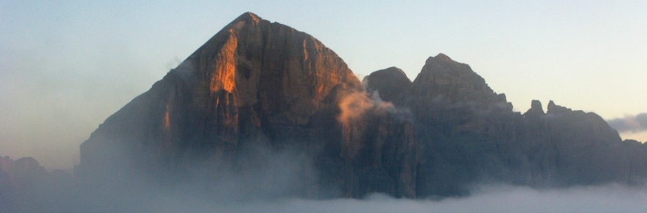
L’Antelao -che pure domina il paese- è meno accessibile ma nella sua intatta bellezza è la più alta cima delle Dolomiti.
The area of San Vito has many possibilities for trips of different levels . The woods between SerDes and Chiapuzza are very beautiful and accessible to all . Sorapiss -cui also accessed dall’Ampezzo and in particular by Faloria- and Mount Pelmo -which dominates San Vito on the opposite side of the Sorapiss- instead offer spectacular walks , and , in some cases long and demanding The Antelao -which also dominates the country- is less accessible but in its untouched beauty is the highest peak of the Dolomites
§ § §
Area: San Vito – Rif. San Marco sul Sorapiss [intera giornata – per tutti – tre/quattro ore – attenzione dopo la frana del 2017 verificare lo stato dei luoghi]
Percorso:
-da San Vito di Cadore si lascia la macchina alla base della seggiovia per il Rif. Scotter Palatini;
– si giunge in seggiovia allo Scotter e quindi a piedi, per il sent. 226 fino al Rif. San Marco (250 m. di dislivello);
– poi per sent. 227 (Alta Via nn. 3 e 4) verso il Rif.Galassi, ma, al bivio con sent. 229, si prende questo verso destra in discesa verso il Rif. Scotter cui si giunge e dove si può riprendere la seggiovia in discesa.
Valutazioni: Gita di buon livello per tutti che ben potrebbe essere un avvio di una gita più lunga articolata [3 h – effettuata 6.8.08]
Path: -from San Vito di Cadore you leave the car at the base of the chair lift to the ref . Scotter Palatine ; – We reach the chairlift to the Scotter and then walk to the felt . 226 to Rif . San Marco ( 250 m . Altitude) ; – Then sent. 227 ( Alta Via Nos . 3 and 4) towards the Rif.Galassi , but , at the junction with sent. 229 , you take this right downhill to the ref . Scotter where we come and where you can take the chairlift downhill . Ratings: Gita good standard for all that well could be a start of a longer trip articulated [ 3 h – carried 08/06/08 ]
§ § §
Area: San Vito – 1) Rif. Senes e Rif. Larin [1/2 giornata – bambinabile – un’ora circa di cammino] – 2) prosecuzione per il Monte la Sentinella e Tabià (Toulà) de la Frates
Percorso:

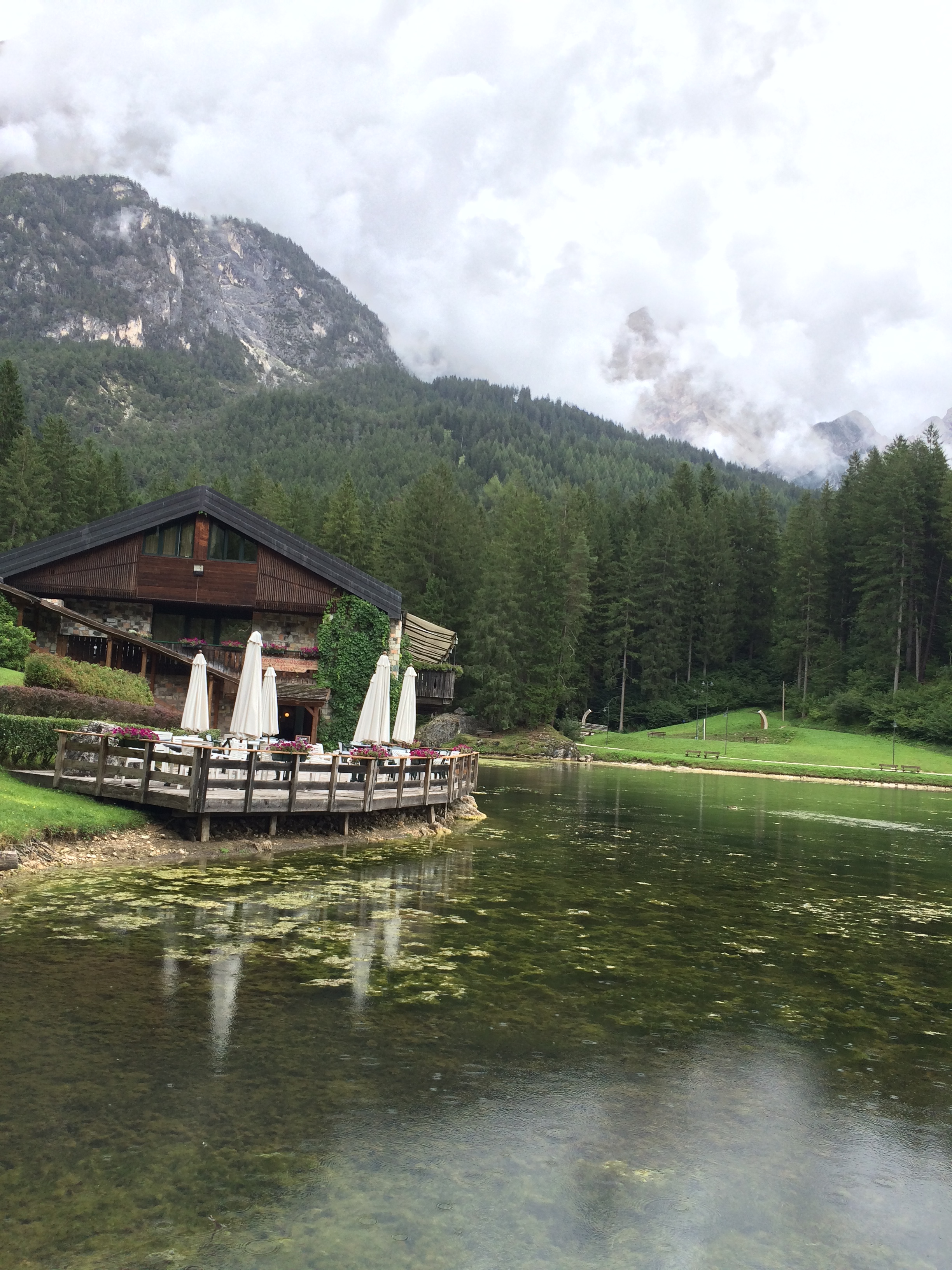 -si lascia l’auto al lago Mosigo (m. 1021 s.l.m., recente set cinematrografico di Ad un passo dal cielo 6) e si prende il sentiero n. 436-458 (o la carrozzabile asfaltata che parte poco prima del lago, e sale sulla destra; oppure possibile anche seguire un sentiero che sale ripido nel bosco, tagliando il percorso carrozzabile) che porta –attraverso il bosco Viza- al Rif. Alpe di Senes (30 min.; m. 1.216 s.l.m.); il ritorno per lo stesso sentiero; i) se si vuole, con altri 5 min. si giunge al Rif. Larin (m. 1.216 s.l.m.; il ritorno per la stessa strada; ii) alternativa per il ritorno può essere proseguendo in discesa dal Rif. Larin (sempre per carrozzabile asfaltata); dopo circa 20 min., ad un tornante, sulla sin. si diparte un sentiero chiuso da una sbarra; prosegue più o meno in quota con bel panorama sull’Antelao, fino al sentiero 436-458 per tornare al Lago (1h/1,15).
Valutazioni: Passeggiatina su carrareccia (oppure -come detto- anche per sentiero più diretto nel bosco), con limitato dislivello – Nel bosco che si attraversa, c’è possibilità di vedere i cervi per l’esistenza di apposite mangiatoie – Arrivo in bella posizione [effettuata 6.8.04 e il 21.8.21 su sentiero con prosecuzione descritta al punto che segue; ii) effettuata 17.8.15]
Path: -you can leave your car at the lake Mosigo and take the road that leads -through the woods Viza- to Rif . Alpe di Senes ( 30 min .; 200 m . in altitude ) ; the return by the same route ; i) if you will, with a further 5 min. get to the Rif . Larin ; the return by the same route ; ii) Alternatively the return may be going down the hill from Rif. Larin (always paved asphalt); after about 20 min . , at a bend, on the right . starts a path closed by a bar ; It continues more or less in proportion with a view Antelao, to the path from 436 to 458 to return to the lake (1h / 1.15) .– Ratings: Stroll onto the track , with a minimum height difference – In the forest you cross , there is a chance to see the deer for the existence of special feeders – Arrival in beautiful location [ carried 06/08/04; ii) 17.8.15 ]
2) Dal Rifugio Senes (1.216 slm) si può proseguire la salita verso il monte La Sentinella ed il Tabià (Toulà) de la Frates. Dal Rifugio attualmente il sentiero 436 (che si è seguito dal Lago di Mosigo al Rifugio stesso e che portava in cima) è impraticabile per gli alberi caduti a causa di Vaia (la tempesta dell’ottobre 2018); – si segue dunque obbligatoriamente una variante non panoramica (segnalata con frecce e cartelli gialli), su sentiero in parte asfaltato / cementato, in parte sterrato, che sale in bosco con pendenza anche forte, senza soluzione di continuità; – la variante riprende finalmente il sentiero 436 al Tabià Ciaupa da Duoe sito in una piccola radura (m. 1634 s.l.m.) che si trova poco dopo la cima della Sentinella; – si prosegue poi in quota con saliscendi nel bosco (ancora ferito da Vaia) fino al Tabià de la Frates (m. 1711 s.l.m.), anch’esso situato in una radura ma sempre nel bosco di proprietà delle Regole di San Vito ed utilizzabile da chiunque si dovesse trovare in difficoltà; – da qui sempre nel bosco, si comincia la discesa per il sentiero 459 (direzione Chiapuzza), prima con sentiero che diviene presto ripido poi su strada camionabile sterrata; si giunge così a livello Boite e in dieci minuti di strada in pianura al lago di Mosigo.
Valutazione: la salita (e poi la discesa) di 700 metri di dislivello, è impegnativa e di poca soddisfazione panoramica. Gita sempre in bosco, penalizzato da Vaia. Tempi di circa tre ore per giungere al Tabià Frates dal lago; ed un’ora e tre quarti per la discesa – non ci sono punti di ristoro; serve buona gamba (effettuata 21.8.21)
2) From the Senes Refuge (1,216 asl) you can continue the climb towards Mount La Sentinella and Tabià Frates. Path 436 is currently impassable for trees that have fallen due to Vaia (storm october 2018); – you must therefore follow a non-panoramic variant (marked with arrows and yellow signs), along a path that is partly asphalted / cemented, partly on a dirt road, which climbs into the woods with a steep slope, without interruption; – the variant finally resumes path 436 at Tabià Ciaupa da Duoe located in a small clearing (1634 m asl) which is located shortly after the summit of Sentinella; – then continue at high altitude with ups and downs in the woods (still wounded by Vaia) up to Tabià Frates (m. 1711 a.s.l.), owned by the Regole di San Vito and usable by anyone who finds himself in difficulty; – from here, still in the woods, you begin the descent along path 459 (towards Chiapuzza), first with a path that soon becomes steep then on a dirt road; This leads to the Boite level and in ten minutes on the flat road to the Mosigo lake.
Evaluation: the climb (and then the descent) of 700 meters in altitude, is demanding and of little panoramic satisfaction. Still in the woods, a little penalized by Vaia.there are no refreshment points; good leg needed – Time of about three hours to reach Tabià Frates from the lake; and an hour and three quarters for the descent (carried out 21.8.21)
§ § §
Area: San Vito – Val Orsolina [1/2 giornata – bambinabile – un’ora circa di cammino]
Percorso:
– si lascia la macchina a Serdes (presso San Vito) e da qui si sale per sent. 470 (in direzione Pelmo), nella valle Orsolina;
-si giunge dopo circa 30/45 min. ad una Chiesa ed al bivio per Borca;
-da qui si può ritornare per la stessa strada.
Valutazioni: passeggiata tranquilla tra prati e boschi [1,5 h – effettuata 9.8.93].
Path: – Leaving the machine to Serdes ( at San Vito ) and from there go up sent. 470 ( towards Pelmo ) , in the valley Ursuline ; -it comes after about 30/45 min . to a Church and the junction for Borca ; -from here you can return by the same route . — Ratings: quiet walk through meadows and woods [ 1,5 h – carried 09/08/93 ] .
§ § §
Area: San Vito – Valli di Forada e Busella e giro del Col de la Puina [intera giornata – cinque ore circa di cammino]
Percorso:
– si lascia la macchina a Serdes (presso San Vito) e da qui si sale per sent. 468 nella valle Orsolina;
-poco dopo sulla sin. si prende il sent. 468 per la Val Feroda, sotto il Pelmo;
-si giunge alla Forcella Forada (600 m. di dislivello dalla partenza);
-si scende poi, seguendo il sentiero 480, fino al Rif. Città di Fiume;
–da qui con il sent. 467 si aggira il Col de la Puina e si giunge alla Forcella Puina (200 m. di dislivello);
-si prosegue con lo stesso sentiero, superando, con leggeri saliscendi, la Forcella Roan e giungendo poi alla Forcella Col de Roan;
-da qui si prende sulla destra il sent. 458 per la Val de Busela;
-al primo bivio, si prende il sent. n. 469 sulla destra; poco dopo, si deve seguire il n. 468 sulla sin. fino al punto di partenza nella Valle Orsolina.
Valutazioni: Gita lunga che è molto faticosa nella parte iniziale per la lunga salita, sotto al Pelmo; la seconda parte rimane più “morbida” e piacevole [effettuata 6.8.86].
Path: – Leaving the machine to Serdes ( at San Vito ) and from there go up sent. 468 Ursuline in the valley ; -little after the sin . you take the felt . 468 to Val Feroda , under the Pelmo ; -reach the Forcella Forada ( 600 m . in altitude from the start) ; – then descends , following the path n. 480 , until the Ref . City of Fiume (=Rijeka) ; -from here with path n. 467 is around the Col de la Puina and reach the Forcella Puina ( 200 m . altitude) ; – continues with the same path , passing , with slight ups and downs , the Forcella Roan and then coming to the Col de Roan ; -from here you take the right path n. 458 to Val de Busela ; -al first fork , take the path n . 469 on the right ; shortly after , you must follow the n. 468 on the right . up to the starting point in the Valley Ursuline . — Ratings: Long walk which is very difficult in the beginning for the long climb , under the Pelmo ; the second part is “softer ” and pleasant [ carried 08/06/86 ]
§ § §
Area: Passo Staulanza – Orme dei dinosauri sul Pelmetto [intera giornata – per tutti – tre / quattro ore di cammino]
Percorso:
-l’accesso migliore è da Passo Staulanza (dopo Selva di Cadore), dove si lascia la macchina;
-da qui si prende il sent. 472 ( = “anello zoldano”), verso il Rif. Venezia, aggirando il Pelmetto;
-dopo circa min. 45, giunto sotto lo spigolo, si devia su per il ghiaione (per circa 40 min. in salita) per vedere le Orme dei dinosauri (cfr. Riv. CAI n. 6/89; Riv. Cortina 1/12).
Valutazione: Un lungo tratto di automobile ma merita di vedere i percorsi che milioni di anni fa degli animali hanno fatto su quello che era un fondale marino – le orme sono di più animali, diversi tra loro; molto istruttiva [effettuata 3.8.89].
Path -by car to Staulanza ( after Selva di Cadore ) , where you leave the car; -from here take the path n. 472 ( = ” ring zoldano ” ) , to the Ref . Venezia (=Venice) , bypassing the Pelmetto ; -after about min . 45 , arrived in the corner , you turn on the scree ( for about 40 min . uphill) to see the footprints of dinosaurs ( cfr . Riv . CAI no . 6/89 ; Riv . Cortina 1/12 ) . — Rating : A long stretch by car but deserves to see the paths that millions of years ago the animals have done on what was a seabed – the tracks are more animals , different from each other ; very informative [ carried 03/08/89 ]