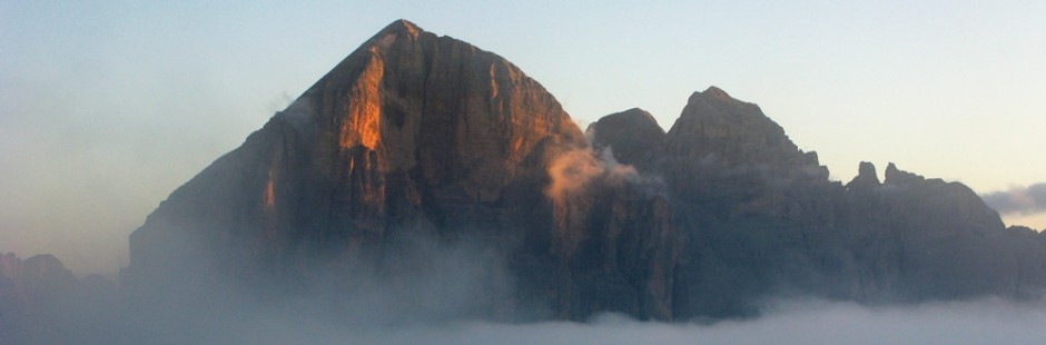
Magnifica valle che fa innamorare della montagna in un contesto naturale ancora intatto nonostante la presenza di luoghi famosi come St.Mor itz, Silvaplana, Celerina, Maloja, ma anche S-champf, Zuoz e Zernez. Percorsa dall’Inn, con la presenza del Parco Nazionale Svizzero, verde e tranquilla, con laghi magnifici, montagne tra i 3.000 e i 4.000 metri, alpeggi incantati, paesi ricchi di storia e cultura
Le gite che si descrivono sono tutte facili, anche se spesso c’è da superare molto dislivello; sono svolte in inverno ed in estate grazie all’ospitalità di amici cari di S-chanf
Magnificent valley that falls in love with the mountain in a natural context still intact despite the presence of famous places such as St.Moritz, Silvaplana, Celerina, Maloja, but also S-champf, Zuoz and Zernez. Itinerary from the Inn, with the presence of the Swiss National Park, green and quiet, with magnificent lakes, mountains between 3,000 and 4,000 meters, enchanting alpine, rich countries of history and culture. The trips described are easy, though often there is a lot of difference; are held in winter and summer; thanks to the hospitality of our dear friends living in S-chanf
§ § §
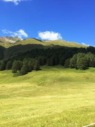
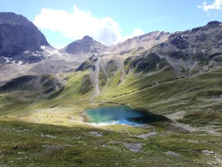
Area: Chinuos – chel: Murter [intera giornata – per tutti – quattro ore di cammino]
Percorso:
-si giunge in auto a La Resgia
-da qui (1.620 s.l.m.) si sale verso  il Murter giungendo in cima (2.2.83 s.l.m.);
– discesa ripida nei boschi su Chinuos – chel;
Valutazioni: Gita bella con salita nei boschi fino ad alti pascoli [effettuata 5.8.07]. La cartina segue (cfr. due gite sotto), ed il percorso è evidenziato in rosa.
° ° °
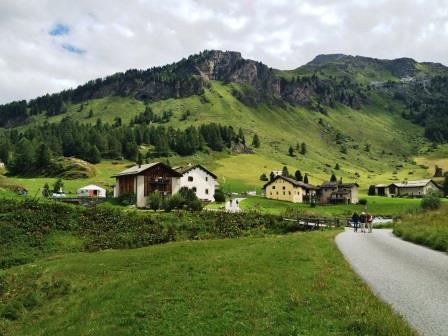
 Area: Chinuos – chel: Val Susauna: [1/2 giornata – i) bambinabile – una /due ore di cammino; ii) per tutti; tre ore]
i) Percorso: -si giunge in auto a La Resgia; -da qui (1.620 s.l.m.) si percorre una dolce valle verso il piccolo centro di Susauna (1.680 m. s.l.m.), tornando per lo stesso sentiero carrozzabile
ii) da Susauna, invece di tornare, si può proseguire per ripida carrozzabile (effettuata con automobile con permesso) fino all’alpe Pignoint (m. 1.898 s.l.m) e da qui si prosegue a piedi sempre per carrozzabile fino all’Alpe Funtauna (m. 2.192 s.l.m.; 45 min. in salita ed altrettanti in discesa), splendida vallata in altura con malga ove poter gustare latte e yogurt naturale.
Valutazioni: passeggiata tranquilla nei prati ed accanto al torrente, quasi in piano, che percorre la prima parte della Val Susauna; proseguendo invece fino all’altopiano, con pascoli di alta montagna, paesaggio naturale ed idilliaco, con marmotte e fiume e bacche di ginepro [i) effettuata 4.8.07; 9.8.16; ii) 18.8.16]; La cartina segue (cfr. una gita sotto), ed il percorso è evidenziato in giallo.
Path: -arrive by car in La Resgia; -from here (1,620 s.l.m.) take a gentle valley to the small town of Susauna (1,680 m. s.l.m.), i) returning along the same path paved; ii) from Susauna, instead of going back, you can continue to steep road (carried out with car with permission) to Alpe Pignoint (1898) and from there it continues always to road up to Alpe Funtauna (2192; 45 min. in climb and the same down), beautiful valley in heights hut where you can enjoy milk and natural yoghurt. Ratings: quiet walk in the meadows and beside the stream, almost flat, running along the first part of the Val Susauna; continuing instead to the plateau, with the high mountain pastures, natural landscape and idyllic, with marmots and the river and juniper [i) carried 04.08.07; 09/08/16; ii) 08.18.16]; The map follows (see. A trip below), and the route is highlighted in yellow.
° ° °
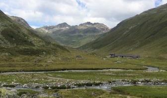
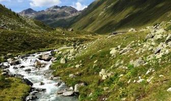
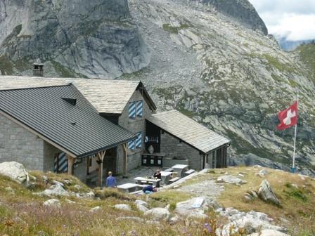
 Area: S-chanf – Parco Nazionale Svizzero e Val Trupchun [intera giornata – sei ore di cammino]
Percorso:
-si lascia l’auto poco prima di S-chanf seguendo il corso del torrente Varusch, salendo dolcemente fino al Rifugio Varusch (da 1.700 a 1.800 m. s.l.m.);
-a questo punto
a) dal Rifugio si può tornare indietro per lo stesso sentiero (complessive 2 h), oppure
b) dal Rifugio, si prosegue inoltrandosi nella valle e nel Parco, salendo fino alla Malga Tropchun, a circa 2.040 m. s.l.m.;
-si attraversa quindi il torrente e si ridiscende la valle dall’altro lato rispetto a quello della salita, nei boschi;
-si arriva così al Rifugio Varusch (2 h) e quindi al luogo di partenza.
Valutazioni: la prima parte della passeggiata è molto piacevole e dolce, fino al rifugio anche un buon ristorante; possibile anche una gita in notturna sulla neve essendo sentiero battuto sempre [effettuata 30.12.09].
La prosecuzione della gita dopo il Rifugio, risalendo la valle Tropchun, porta in uno scenario ampio e naturale, dove è possibile vedere stambecchi e camosci, oltre all’avvoltoio grifone [effettuata il 2.8.04]. Il percorso è riportato in giallo sulla cartina che segue.
(full day – six hours of walking] Path: – leaves the car just before S-chanf following the course of the Varusch stream, gently climbing up to the Varusch Rifle (from 1,700 to 1,800 m.); -at this point a) From the Refuge you can go back for the same trail (total 2 h), or b) from the Rifugio, continue to the valley and the park, going up to the Tropchun Mountain, about 2,040 m. s.l.m .; – then crosses the torrent and goes down the valley on the other side of the climb, in the woods; – you come to the Varusch Lodge (2 h) and then to the starting place. Reviews: The first part of the walk is very pleasant and sweet, up to the shelter also a good restaurant; It is also possible to have a night outing on the snow as it is always beaten path [performed on 30.12.09]. The continuation of the excursion after the hut, going up the Tropchun valley, leads to a wide and natural scenery, where you can see ibexs and chamois, in addition to the Griffin vulture [on 2.8.04].
 °
°Area S-chanf: Alpe di Acla Laret (2-2.30 h – per tutti)
Percorso: dal paese di S-chanf (m. 1.662 s.l.m.), passata la ferrovia, si sale per ripidi sentieri su prati fino ad una malga l’Acla Laret (alpe grande; m. 2.000 s.l.m.; 1 h); si prosegue in quota e poi per sentiero in discesa tra i boschi, per Chapella; poco prima del paese bivio sulla sinistra per S-chanf, con parte finale che costeggia la ferrovia (1,15 h)
Valutazioni: dall’Acla laret bel panorama sulla valle – in zona pur difficilmente rintracciabili, vi sono vestigia paleolitiche – il bosco ben curato e l’area tutta è tipicamente locale; molte fragoline (effettuata l’11.8.16)
Path: From the village of S-chanf (m. 1,662 s.l.m.), pass the railroad, climb up steep paths on meadows up to Acla Laret (2,000 s.l.m., 1 h); Continue on high and then downhill path through the woods to Chapella; just before the crossroads on the left for S-chanf, with the final end near the railroad (1.15 h) – Reviews: beautiful panorama of the valley – in the area though difficult to trace, there are Paleolithic vestiges – the well-kept woodland and the area is typically local; many strawberries (made on 11.8.16)
§ § §
Area: La Punt / Bergun – Albula Pass [notturna invernale – con torce in slittino – tre ore circa]
Percorso:
– si lascia la macchina alla stazione di La Punt e si prende il treno per l’Albula Pass (d’inverno la strada è chiusa);
-dall’Albula si scende per la strada cantonale –appunto chiusa- in slittino fino alla cittadina di Bergun (circa 800 m. di dislivello in circa 8 km mozzafiato);
-premia la cena a Bergun, dalla cui stazione poi si prende il treno che riporta a La Punt.
Valutazioni: Esperienza che implica conoscenza di guida dello slittino, ma che per la lunghezza del tracciato, per la sua spettacolarità ed anche per la frequentazione è quasi unica [effettuata 29.12.09].
winter and by night – 3 h- leave the car at La Punt station and take the train to the Albula Pass (in winter the road is closed); – From the Albula you go down the canton road – closed – sledding to the town of Bergun (about 800 m of altitude in about 8 kmbreathtaking); -dinner in Bergun, from where you can take the train to La Punt. Ratings: Experience involving knowledge of sled drive but the length of the track, its spectacularness and even the attendance is almost unique [performed on 29.12.09].
°
Area: Albula pass: Rifugio Es-cha sull’Albula (4 h; per tutti)
 Percorso: si sale al passo dell’Albula con l’auto; in loc. Val d’Alvra – Funtaunas a quota 2.200, si lascia l’auto in parcheggio – Un senterio sulla destra della strada sale su prati ed alti pascoli, panoramicamente, alla forcella Gualdauna (m. 2.491 s.l.m.); prosegue poi in un ampio anfiteatro naturale, restando in quota e poi in leggera salita, fino al Rifugio (=Chamanna) Es – cha (m. 2.594 s.l.m.; 1,5 h). – Da qui un bell’ambiente ove passeggiare e fare pic-nic, con laghetto. – La discesa verso Madulain su comodi sentieri, costeggia torrenti e, dopo Belvair, rientrando nel bosco, diviene ripida, perdendo circa 900 metri dislivello. Si giunge infine a Madulain (m. 1.700 s.l.m., circa; 2h)
Valutazioni: giornata magnifica, con un panorama spettacolare, marmotte in quota; attenzione però che la discesa è lunga e la lunghezza complessiva della gita è di circa 14 km. (effettuata il 13.8.16)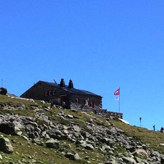
Path: climb up the Albula Pass with your car; in loc. Val d’Alvra – Funtaunas at m. 2.200, leaves the car in a park area- A path on the right of the road rises on meadows and high pastures, panoramically, to the Gualdauna fork (2.491 m.); then continues into a large natural amphitheater, remaining at altitude and then uphill, up to the Rifugio (= Chamanna) Es – cha (2,594 m, 1,5 h). – From here a nice environment where to walk and picnic, with pond. – The descent to Madulain on comfortable hiking trails runs along streams and, after Belvair, entering the woods, becomes steep, losing about 900 meters in altitude. Finally, arrive at Madulain (1,700 m, about 2h) Reviews: magnificent day, with spectacular views, altitude marmots; however, the downhill is long and the overall length of the trip is about 14 km. (made on 13.8.16)
° ° °
Area: La Punt / Bever – Spinas [1/2 giornata – per tutti in bici – tre ore circa]
Percorso:")
– si lascia la macchina a La Punt e per la ciclabile della valle si giunge a Bever (0,5 h);
-da qui si sale per la Val di Bever giungendo su carrozzabile in mezzo ai prati alla stazione di Spinas (circa 100 m. di dislivello; 1,5 h);
-alla stazione c’è un punto di piacevole ristoro, e quindi ben si può tornare per la stessa strada (1 h).
Valutazioni: Paesaggio tranquillo specie nella seconda parte della gita che potrebbe anche partire e arrivare da Bever; la parte finale da Bever a La Punt è infatti in leggera salita; è comunque una tranquilla passeggiata in bici con i suoi bei chilometri [effettuata 6.8.07].
for bikers: leave the car at La Punt and take the bike lane to Bever (0.5 h); – from here climb for the Val di Bever, coming on a carriage in the middle of the meadows at Spinas station (about 100 m in altitude, 1.5 h); -the station has a nice refreshment point;, you can go back to the same way (1h). Reviews: Quiet landscape in the second part of the excursion that could even start and arrive from Bever; the final part of Bever at La Punt is infact a slight uphill; it is still a quiet bike ride with its beautiful kilometers [made 6.8.07].
° ° °
Area: Val Bernina – Muottas Muragl [in slittino in inverno] e Capanna Segantini (intera giornata; 4 h)
Percorso:
– poco prima di Pontresina, si lascia la macchina a Punt Muragl (m. 1.800 circa) dove si prende la cremagliera per Muottas Muragl;
-dalla cima di Muottas Muragl (m. 2.543) un magnifico panorama; poi per il sentiero / pista in inverno, si scende tra i boschi (a piedi o in slittino, a seconda delle stagioni) fino ad un bivio, loc. Margun (20 min.);
qui due opzioni: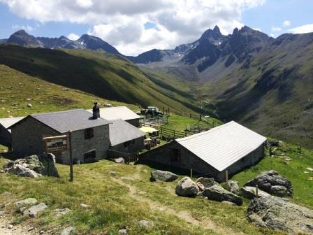
i)si prosegue sul sentiero a destra in discesa
ii)si sceglie un sentiero sulla sinistra verso Muragl che sale lievemente fino ad altro bivio per Capanna Segantini (20 min); da qui una salita ripida, su roccia, alcuni scalini, e poi ancora roccia porta al rifugio (m. 2.731 s.l.m.; 1h). – La discesa per lo stesso sentiero fino al bivio di Margun (45 min.).
 Il sentiero è a questo punto lo stesso per le due opzioni. Da qui per prati popolati da marmotte, giù, giù, nel bosco con una discesa lunga e anche dura. Si giunge nuovamente alla stazione della cremagliera (2h, dopo aver prso circa 1.100 metri di quota).
Valutazioni: In slittino la pista è piuttosto ripida nella prima parte molto più scorrevole nella seconda; necessita di esperienza, ma se ne fa più di una… [effettuata 2.1.10]. In estate, dopo la salita alla Capanna, magnifico panorama su tutta la valle e sui ghiacciai; salita dura e discesa anche; soddisfatti (effettuata 16.8.16)
Shortly before Pontresina, leave the car at Punt Muragl (approx. 1,800 m) where you will take the rack for Muottas Muragl; – From the top of Muottas Muragl (2,543 m) a magnificent view; then on the path / trail in winter, you go down the woods (walk or toboggan, depending on the seasons) to a fork, loc. Margun (20 min.); here are two options: i) continue on the downhill, taking the path on the right; ii) choose the path on the left towards Muragl which rises slightly until another junction for Capanna Segantini (20 min); from here a steep climb, on a rock, a few steps, and then again rock leads to the hut (m 2.731 s.l.m, 1h). – The descent for the same trail until the junction of Margun (45 min.). The path is at this point the same for the two options. From here there are meadows populated by marmots; go down and down, in the forest with a long and hard descent. You will come back to the rack station (2h, after having about 1.100 meters altitude). Ratings: In toboggan/sledding run the track is quite steep in the first part much sliding in the second; needs experience, but it does more than one … [performed 2.1.10]. In the summer, after climbing to the hut to Segantini, magnificent views across the valley and the glaciers; hard but beautiful (performed 16.8.16)
° ° °
Area: Val Bernina – Morteratsch [1/2 giornata – bambinabile – una / due ore di cammino per ghiacciaio e formaggio].
Percorso:
– prendendo la Val Bernina da Pontresina, si lascia la macchina a Morteratsch; 
– si risale a questo punto a piedi la valle verso il ghiacciaio, su sentiero molto comodo e con lieve dislivello, giungendo alla fine della lingua del ghiacciaio del Piz Morteratsch e Piz Bernina (il Gletscherange) dopo circa 45 min.
– al ritorno presso il Morteratsch, ci si può fermare a vedere come viene fatto il formaggio … ed assaggiarlo!
Valutazioni: Giungere a “toccare” il ghiacciaio così imponente è emozionante, pur se impressionano i segnali che indicano dove in passato il ghiacciaio giungeva, essendosi oggi ritirato; impatto spettacolare con pochissimo sforzo [effettuata 17.8.04]. La passeggiata è premiante anche perché in alcune giornate è possibile vedere come viene fatto il buon formaggio svizzero … [effettuata 8.8.07]. La cartina del percorso è qui di seguito.
Leave the car at Morteratsch (val bernina, from Pontresina); from this point by walking the valley to the glacier, on a very comfortable path and with a slight difference in height, reaching the end of the tongue of the Piz Morteratsch glacier and Piz Bernina (the Gletscherange) after about 45 mins. – Returning to the Morteratsch, you can stop seeing how the cheese is made … and taste it! Ratings: Arriving to “touch” the impressive glacier is exciting, though impressed by the signs indicating where the glacier was in the past, having retreated today; spectacular impact with little effort [performed on 17.8.04]. The walk is also rewarding because in some days you can see how good Swiss cheese is made … [performed on 8.8.07].
")
° ° °
Area: Val Bernina – Diavolezza [intera giornata – per tutti – tre ore di cammino]
Percorso:
– prendendo la Val Bernina da Pontresina, si lascia la macchina alla partenza della funivia di Diavolezza;
– la funivia porta a 2.978 m. s.l.m. nel cuore dell’anfiteatro del ghiacciaio del Bernina (esattamente tra Piz Palù, Piz Bernina, Piz Morterastch), nel mezzo di un imponente spettacolo; 
– da qui per un sentiero si scende fino alla base della funivia a 2.093 m. s.l.m.
Valutazioni: Si è immersi in uno spettacolo incredibile in cima; quindi la discesa bella e un po’ impegnativa (in tre ore si scende di 900 m.) [effettuata 16.8.04]. La cartina del percorso è poco sopra.
To Val Bernina from Pontresina, leaves the car at the start of the Diavolezza cable car; – The cableway leads to 2,978 m. s.l.m. in the heart of the amphitheater of the Bernina glacier (exactly between Piz Palù, Piz Bernina, Piz Morterastch), in the middle of an imposing spectacle; from here a path goes down to the base of the cableway at 2,093 m. s.l.m. Ratings: It is immersed in an incredible spectacle on top; then the beautiful descent and a bit demanding (in three hours it goes down 900 m.) [performed on 16.8.04]. The route map is just above.
°
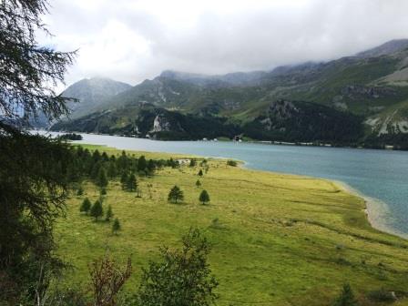
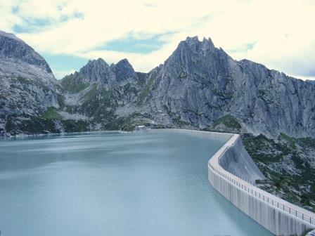
Area: Passo Bernina – Lago Bianco (per tutti, 1h)
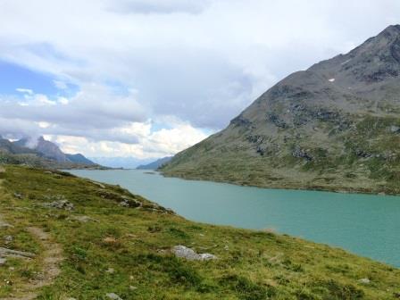 Percorso: Dall’Ospizio Bernina – Rif. Cambrena (m. 2.330 s.l.m.), dove si arriva in auto, si scende verso il Lago Bianco e si percorre il piacevole sentiero che lo costeggia, fino alla diga sulla valle; si può fare il giro dell’inetro lago ovvero (stante le condizioni del tempo che abbiamo trovato) tornareindietro sulla stessa strada (1h, in piano).
Valutazioni: piacevole passeggiata lungo lago, con attraversamento delle rotaie del trenino del Bernina; in piano (effettuata 15.8.16).
Route: From the Bernina Hut – Rif. Cambrena (2.330 m), where you arrive by car, head down to the White Lake and walk along the pleasant path that runs through it to the dam on the valley; you can go around the lake, or (due to the weather conditions we have found) you have come back on the same road (1h). Reviews: Pleasant walk along the lake, crossing the Bernina train rails (done 15.8.16)
° ° °
Area: Passo Bernina – Val Viola [intera giornata – per tutti – tre/quattro ore di cammino]
Percorso:")
– prendendo la Val Bernina da Pontresina, superato il Passo e iniziata la discesa, dopo la deviazione per Livigno (I) si giunge a Sfazù; si lascia la statale e poi verso sinistra; superati alcuni paesini si giunge a Terzina, dove si lascia la macchina;
-si prende il sentiero per il lago Saoseo dove si giunge e si prosegue verso il Rifugio Saoseo (400 m. di dislivello; 2,15 h);
-ritorno per la camionabile alla partenza (1,15 h).
Valutazioni: Un po’ lunga la gita in macchina ma bello il panorama del lago ormai al confine con l’Italia [effettuata 7.8.07].
To Val Bernina from Pontresina, cross the Pass, after the deviation to Livigno (I) reach to Sfazu; leave the principal road and take the left one to Terzina, where you leave the car; – take path to Lake Saoseo where you will arrive; continue towards the Saoseo Refuge (400 m in altitude, 2,15 h); -right for the truck at departure (1.15 h). Reviews: A little long ride in the car but beautiful panorama of the little lake on the border with Italy [made 7.8.07]
° ° °
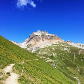
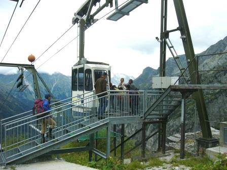
Area St.Moritz – Piz Nair (intera giornata – 4 h di cammino)
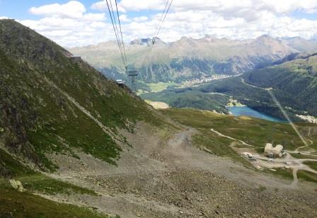
 In St.Moritz, si prende la funivia Signal, giungendo a m. 2.182 s.l.m.. – Da qui un sentiero in salita per strada sterrata ripida (45 min; circa 300 m. di dislivello) fino alla partenza della funivia Corviglia (m. 2.486 s.l.m.; peraltro raggiungibile direttamente anche con cremagliera dal centro di St.Moritz) – con la funivia si giunge comodamente sul Piz Nair (m. 3.057 s.l.m.), dopo un percorso spettacolare che passa sopra la pista dei campionati del mondo di sci del 2017 (sopra la partenza della discesa libera; da brivido).- Panorama incredibile a 360° dal rifugio –
La discesa nel primo tratto è ripida e su sentiero di rocce quasi lunari e scure; giunti al lago di Suvretta (m. 2.615 s.l.m.) il panorama cambia e diventa più dolce, con prati di alta quota; il sentiero prosegue poi sempre in discesa su prati, vicino a torrenti, poi ancora nel bosco. Si giunge dopo lunga discesa (2,5 h) alla base della seggiovia Suvretta (circa m. 1.800 s.l.m.) alla periferia di St.Moritz.
Valutazioni: gita spettacolare e con varietà di ambienti; la salita oltre i temila metri è fantastica. Attenzione al meteo, quando si sale così tanto. La discesa è molto lunga (quasi 1.200 metri di dislivello) e senza altri punti di ristoro; buone gambe necessarie (effettuata 14.8.16)
In St.Moritz take the Signal cable car, arriving at m. 2.182 slm – From here a steep path for steep dirt road (45 mins, about 300 m in altitude) until the departure of the cable car Corviglia (2,486 m above sea level, but can also be reached directly with a rack from the center of St.Moritz) – with the cable car, you can easily reach the Piz Nair (3.057 meters above sea level), after a spectacular passage over the 2017 ski world ski run (above the start of the free descent) – 360 ° unbelievable panoramic view hut – The descent in the first section is steep and on a trail of almost moonish and dark rocks; at the lake of Suvretta (2,615 m), the landscape changes and becomes sweeter, with high altitude meadows; The path then continues downhill on meadows, near streams, then again in the woods. It comes after a long descent (2.5 h) at the base of Suvretta chairlift (about 1.800 m) at the outskirts of St.Moritz. – Reviews: Spectacular getaway and variety of environments; the climb over the temila meters is fantastic. Beware of the weather when you climb so much. The descent is very long (almost 1,200 meters in altitude difference) and without any other refreshment points; good legs needed (made 14.8.16)
° ° °
Area Sils Maria Val di Fex
Percorso: da Sils Maria, dietro la stazione di partenza della funivia di Furtshellas (m. 1.806 s.l.m.), un sentiero nel bosco sale comodamente verso Resgia, Vanchera, Platta e al Ristorante della val di Fex (45 min. circa m. 2.000 s.l.m..) – si prosegue nel bosco e si scende verso Isola, piccolo paesino a metà del lago di Segl, dove si può mangiare al sacco magari sul lago. – il sentiero prosegue seguendo il lago, ma nel bosco, fino a Sils.
Valutazioni: gita tranquilla, con lieve dislivello e relativi sali-scendi. Panotrama sul lago; rilassante (effettuata il 10.8.16).
Route: From Sils Maria, behind the departure station of the cable car of Furtshellas (M. 1,806 A.S.L.), a path in the forest rises comfortably towards Resgia, Vanchera, plate and the restaurant of the Val di Fex (45 min. about M. 2,000 A.S.L.)-Continue in the woods and descend towards Isola, small village in the middle of Lake Segl, where you can eat the sack maybe on the lake. -The trail continues along the lake, but in the woods, to Sils.- Ratings: Quiet tour, with slight elevation and relative salts-descend. Panotrama on the lake; Relaxing (performed on 10.8.16).
° ° °
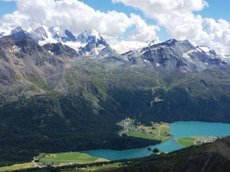
Area: Silavaplana – Corvatsch e Val Roseg [intera giornata – per tutti – tre ore di cammino]
Percorso:")
– si lascia una automobile a Pontresina e quindi si prosegue con altra finchè si giunge a Silvaplana;
– qui si prende la funivia del Corvatsch, 
fino alla (prima) stazione di Murtel (m. 2.689);
– giunti in cima si sale ancora in un paesaggio alpino (circa 100 m. di dislivello) fino al Rifugio Berghaus Fuorcla Surlej (2.760 s.l.m.);
 – il rifugio è accanto ad un bel laghetto e si gode un magnifico panorama sui ghiacciai del Bernina;
– la discesa piuttosto ripida ma molto bella panoramicamente, porta al Rif. Roseg in Val Roseg (1999 s.l.m.);
– da qui, su una carrozza trainata da cavalli, si percorre tutta la Val Roseg e si giunge (dopo circa 45 min.) a Pontresina.
Valutazioni: Passeggiata panoramicamente spettacolare in sostanziale (seppur ripida) discesa; la passeggiata in carrozza ha il suo divertente fascino [effettuata 2.7.11].
Leave a car in Pontresina and then continue with the other car until you reach Silvaplana; – here you take the Corvatsch cable car,to the (first station, Murtel (2,698 m); – climbing to the top is still in an alpine landscape (about 100 m altitude difference) to Berghaus Rifugio Fuorcla Surlej (2,760 m); – the hut is beside a beautiful pond and enjoys a magnificent view of the Bernina glaciers; – the steep but very beautiful descent panoramic, leads to the Roseg Refuge in Val Roseg (1999 s.l.m.); – From here, on a horse-drawn carriage, drive through the Val Roseg and arrive (after about 45 min.) to Pontresina. Reviews: Panoramic spectacular walk in substantial (albeit steep) downhill; the carriage ride has its fun charme [perfomed on 2.7.11].
 § § §
§ § §
Area: Val Bregaglia – Albigna [intera giornata – per tutti – due/ tre ore di cammino]
Percorso:
 – si percorre tutta l’Engadina fino al Maloja; superato il Maloja, alla fine della discesa del Passo, poco prima di Vicosoprano, si lascia la macchina presso Pranzarra, al parcheggio della partenza della funicolare dell’Azienda elettrica di Zurigo, chiaramente visibile sulla sinistra della strada;
–si prende la funicolare (rectius bidonvia, che, essendo privata e non turistica, ha orari particolari; dunque informarsi prima) che sale verso la diga dell’Albigna; una salita ripida e con poche persone; sulla sinistra salendo si vede il severo viso della montagna che ci guarda;
-giunti in cima si attraversa la diga (800 m. circa di lunghezza) e si arriva sul lato sinistro del lago artificiale, sul monte;
-si sale così fino al Rifugio Capanna d’Albigna, ai piedi del ghiacciaio che alimenta il lago (2 h);
-il ritorno per la stessa strada. ")
Valutazioni: La salita in “funicolare”, che copre, senza piloni, 1.000 metri di dislivello è di per sé un’avventura poiché si sta nel bidone stretto, con poca capienza che va su e giù fino alla diga; il piccolissimo bidone vola altissimo e porta ad una diga enorme; salendo sulla sin. si vede la roccia che appare come un volto … sotto in valle, a grande distanza, alcuni camosci passeggiano tranquilli. Tragitto indimenticabile e di impatto. – La passeggiata successiva consente prima di camminare sulla diga che è enorme ed a picco sulla valle; poi porta al Rifugio proprio ai piedi del ghiacciaio (che si vede sin dalla partenza); attenzione alla temperatura che anche in estate è “freschetta” [effettuata 10.8.07].
Drive across the Engadine to Maloja; after passing the Maloja, at the end of the descent of the Pass, shortly before Vicosoprano, leaves the car at Pranzarra, at the park of the Zurich Electric Company funicular, clearly visible on the left of the road; – take the funicular (rectius bidonvia, which, being private and not touristic, has special times, therefore inquire first) that ascends to the dam of Albigna; a steep climb with few people; on the left climbing up you can see the stern face of the mountain that looks at you; – at the top, cross the dam (800 m in length) and arrive at the left side of the artificial lake on the mountain; – it goes up to the Rifugio Capanna d’Albigna, at the foot of the glacier feeding the lake (2 h); -the return of the same road. Ratings: The climbing “funicular” which covers, without pilons, 1,000 feet of altitude is an adventure in itself because it is in the narrow canopy, with little capacity going up and down to the dam; the tiny bin runs very high and leads to a huge dam; ascending on the left side you can see the rock that looks like a face … under the valley, at a distance, some chamois walk quietly. Unforgettable journey and impact. – The next walk allows before walking on the dam that is huge and peaked on the valley; then leads to the hut right at the foot of the glacier (seen from the start); attention to the temperature that even in the summer is “freschetta” [performed on 10.8.07].