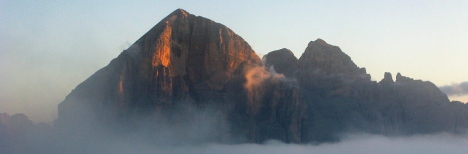
 Il Gruppo delle Tofane offre diverse tipologie di gite, da quelle corte e facili, a lunghe fino alle ferrate, anche difficili. Nella zona di Piè Tofana e di Col Druscé le gite sono corte e facili; la zona di Ra Valles le gite sono più impegnative e lunghe; nella zona Tofana di Mezzo e la Tofana di Rozes, la gran parte delle gite proposte sono sentieri ferrati oppure vie ferrate; la zona di Col dei Bos e l’accesso alla Val Travenanzes con gite di tutte le tipologie. Nel Gruppo delle Tofane rientra il Col Rosà, cui pure si accede per via ferrata. E’ inutile dire –ma è una nota personale- che le sensazioni che danno le Tofane, ed in particolare la Rozes, quando vengono scoperte o raggiunte, sono indescrivibili.
Elenco delle passeggiate: I. Sentiero Montanelli e salita alle Crepe di Cianderou; II. dal Montanelli al Lago Ghedina; III. Tondi di Cianderou; IV. Ghiaione Ra Ola; V. Via Ferrata Aglio alla Cima Tofana; VI. Sentiero ferrato Olivieri (da Pomedes a RaValles); VII. Via Ferrata Ra Buiela (torrione destro Pomedes); VIII. Via Ferrata Ra Pegna (torrione sinistro Pomedes); IX. Sentiero ferrato Astaldi + Via Ferrata Grotta di Tofana su Tofana di Rozes; X. Cima Tofana di Rozes; XI. Via Ferrata Galleria del Castelletto; XII. Via Ferrata Lipella su Tofana di Rozes; XIII. Col de Bos; XIV. Via Ferrata degli Alpini al Col de Bos; XV. Val Travenanzes; XVI. Via Ferrata al Col Rosà
The Tofane Group of mountains offers various types of walk, from the short and easy to the long and then those with via ferrata, which can even be difficult. In the Piè Tofana and Col Druscé area the walks are short and easy; in the Ra Valles area they are more demanding and long; in the Tofana di Mezzo and Tofana di Rozes area most of the walks proposed are assisted paths or full “vie ferrate”; in the Col dei Bos area and at the entrance to the Val Travenanzes there are walks of every type. The Tofane group includes Col Rosà, to which access is also by via ferrata. Needless to say –but it is a personal observation- the sensations provided by the Tofane, and in particular la Rozes, when you see them, are indescribable.
§ § §
 I – Area: Tofane – Piè Tofana/Col Druscé : “Passeggiata Montanelli” [1/2 giornata – gita bambinabile – un’ora di cammino]
Percorso:
-si giunge con l’automobile a Piè Tofana (m. 1.675 s.l.m.) -anzi poco dopo il rifugio in un ampio piazzale di terra battuta – dove si parcheggia e da qui si procede a piedi in direzione Col Druscé;
-da qui, in piano, si segue il c.d. sentiero della Passeggiata Montanelli (sent. 410; 20/30 min.; 20 metri di dislivello per circa 1.2 km); piacevole poichè largo, prima nel bosco poi panoramico, sostanzialmente pianeggiante, fino ad un primo bivio: da qui possibili diverse opzioni (oltre a quella di tornare indietro per la stessa strada):
i) se si prende il sent. di destra in discesa nel bosco, si giunge al lago Ghedina (m. 1.457 s.l.m. – sent. 413; vedere gita che segue);
ii) se si prosegue per il sentiero 410, invece, si prosegue il sentiero Montanelli fino ad un secondo bivio dove il sentiero termina; sulla sinistra c’è il sent. 409 che, salendo per comodo sentiero, porta alle Crepe di Cianderou e prima (a circa 1.700 m. s.l.m.), ad un Belvedere che merita, con vista proprio sopra lago Ghedina (m. 1.753 s.l.m.; 45 min. /1 h; effettuata 5.8.13; 15.8.17; 18.8.23).")
iii) dopo il Belvedere si può proseguire per lo stesso sentiero n. 409 nel bosco superando le Crepe di Cionderou e proseguendo “a volontà” verso il passo Posporcora o prendendo più avanti il sent. 446 in salita; noi abbiamo evitato la deviazione e abiamo proseguito piacevolmente per 1 h circa fino al Valon del la Foia (bella “sgambata” il 1.11.16)
-il ritorno è per lo stesso sentiero (410); si segnala che all’altezza del bivio per il lago Ghedina, dal lato opposto al sent. 413, vi è una traccia di sentiero che corre parallela alla “Passeggiata di Montanelli” e che per i bambini è certamente migliore, poiché è su bei prati e, pur essendo in posto molto accessibile non è mai affollata ed ottima per pic-nic.
Valutazioni: Passeggiata tranquilla anche con prati e boschi, da prolungare a piacimento. A meno che non si scelga la variante i) ove c’è il lago ed un rifugio / ristorante, è necessario portare con sé acqua e panini [effettuata più volte come sgambatina, magari con tempo uggioso; ultima volta fino al belvedere 18.8.23; il Montanelli per intero il 14.8.21].
Area: Tofane – Piè Tofana/Col Druscé : “Montanelli Walk” [half a day –suitable for children – one hour of walking]
Route: -Park at Piè Tofana and from here proceed on foot in the direction of Col Druscé; – From here, on the flat, follow the so-called “Passeggiata Montanelli” (“Montanelli Walk”) path (path no. 410; 30 mins), as far as a junction. Here there are two options: i) If you take the path on the right that goes down, you reach Lake Ghedina (path no. 413; see next walk); ii) If you instead continue on the same path, further on, on the left, you will find path no. 409 which climbs and brings you to Crepe di Cianderou and, especially, significantly before that, to a viewpoint which merits a stop, with a view precisely over Lake Ghedina (1 h). – iii) After the Belvedere you can continue for the same trail no. 409 in the woods over the Crepes of Cionderou and continuing “at will” towards Posporcora step or taking forward the sent. 446 uphill; We avoided the deviation and we continued pleasantly for about 1 hour until the Valon of Foia (beautiful on 1.11.16) – The return journey is by the same path (410); It should be pointed out that at the junction for Lake Ghedina, on the opposite side to path no. 413, there are traces of a path that runs parallel to the “Passeggiata Montanelli” and which is certainly better for children as it has some nice grassy expanses and, even if the place is very easily accessible, it is never busy and is excellent for a picnic. Assessment: Easy walk through woods and grassy expanses, which can be added on to as you wish [carried out several times to stretch our legs, maybe with overcast weather].
° ° °
 II – Area: Tofane – Col Druscé – Lago Ghedina [intera giornata – gita bambinabile – due ore circa di cammino]
Percorso:
-si giunge a Col Druscé (grazie alla funivia) e da qui, in discesa per il sent. 413 nei boschi fino a Lago Ghedina (1,5 h; 300 m. di dislivello in discesa) – qui è possibile la pesca di trote…
– si prosegue poi con il sent. 410 e, sempre in discesa tra boschi, si giunge a Cadin (20 min.), ove si è lasciata preventivamente l’automobile.
Valutazioni: Passeggiata tranquilla anche con prati e boschi – il lago è una bella attrazione per i bimbi (potendo anche pescare), oltre ad essere un gioiellino della natura – va tenuta presente l’organizzazione delle automobili per il ritorno [effettuata 16.8.98].
Area: Tofane – Col Druscé – Lake Ghedina [whole day – walk suitable for children – two hours of walking]
Route: – Go to Col Druscé (with the cable car) and from here, descend by path no. 413 crossing woods as far as Lake Ghedina (1h30; 300 m. decrease in altitude) – where it is possible to fish for trout… – continue on path no. 410 and, again descending through woodland, you will reach Cadin (20 mins), where you should have left a car in advance.
Assessment: easy walk, grass and woodland – the lake is a nice attraction for children (given that you can fish too), as well as being a wonder of nature – you should bear in mind that you need to organise cars for when you go back [carried out on 16.08.98].
§ § §
III –Area: Tofana – Ra Valles: Tondi de Cianderou [intera giornata – per tutti – quattro/cinque ore di cammino]
Percorso:
-si giunge in funivia fino a Ra Valles;
-da qui sulla destra, seguendo il sent. 407, si giunge alla forcella Ra Valles (che è la partenza della nota pista di sci, Forcella Rossa (150 m. di dislivello in discesa);
-si prosegue con il sent. 446 verso Ra Zestes (sent. 446, 150 m. di dislivello in salita)
-il sentiero prosegue poi su e giù per i Tondi de Cianderou, rimanendo complessivamente più o meno in quota, fino a giungere all’inizio della discesa su Cortina (sino a qui circa 2h);
–per il ritorno le possibilità sono due:
i) tornare sui propri passi e dunque fino alla forcella Ra Valles (1 h);
-quindi (sostanzialmente per la pista da sci), si scende per sent. 407 fino a Piè Tofana (circa 1,5 h – 450 m. dislivello in discesa) dove si è lasciata preventivamente un’automobile, oppure da cui si sale (per sent. 410 e 411) a Col Druscé (15 min.) per riprendere la funivia.
ii) si scende per il sent. 446, in modo piuttosto ripido;
-al primo bivio si prende sulla destra il sent. 409 che porta al lago Ghedina (600 m. di dislivello in discesa; 1,30 h), dove si è lasciata preventivamente un’automobile oppure da cui si prosegue per Cadin (vedi gita che precede).
Valutazioni: Gita bellissima, poco anzi pochissimo frequentata e panoramica, adatta a tutti pur se va considerata la discesa notevole – interessante per i ruderi e per le trincee sulle creste dei Tondi – prati di stelle alpine [effettuata 18.8.92; 7.7.10].
Area: Tofana – Ra Valles: Tondi de Cianderou [whole day – for everyone – four/five hours of walking]
Route: -Take the cable car to Ra Valles; – From here take path no. 407 towards the right until you reach the Ra Valles saddle (start of the famed Forcella Rossa ski slope (150 m. decrease in altitude); – Continue with path no. 446 towards Ra Zestes 150 m. increase in altitude); – The path then continues up and down crossing the “Tondi de Cianderou”, remaining overall more or less at the same altitude, until you reach the start of the descent towards Cortina (about 2h up to here); -Going back there are two options: i) Go back the same way and therefore as far as Ra Valles (1 h); -Then (essentially following the ski slope), descend on path no. 407 as far as Piè Tofana (about 1h30 – 450 m. decrease in altitude) where you should leave the car in advance or alternatively go up (by paths 410 and 411) to Col Druscé (15 mins) to take the cable car again. ii) Descend by path no. 446, which is rather steep; – At the first junction take path no. 409 on the right, which takes you to Lake Ghedina (600 m. decrease in altitude; 1h00, where you should park the car in advance or continue from here to Cadin (see previous walk).
Assessment: Excellent walk, not busy, in fact not at all busy, and with panoramic views, suited to everyone even if you need to take account of the steep descent – interesting for the ruins and trenches on the Tondi ridges – fields of edelweiss [carried out on 18.8.92; 07.07.10].
§ § §
IV – Area: Tofana – Ra Valles Ghiaione di Ra Ola [intera giornata – cinque/sei ore di cammino]
Percorso:
– si giunge in funivia fino a Ra Valles
– si prende il sent. 407 verso la Tofana di Dentro (“attraversando” quelle che d’inverno sono le piste sulla destra arrivando) e quindi scendendo prima e risalendo ma seguendo sempre il sentiero, fino a giungere in quota sulla Tofana, a mezza costa;
– si prosegue ancora sul sentiero (il c.d. “sentiero dei volontari”), tenendo la destra e così superando il bivio per Cima Formenton;
– dopo alcuni baraccamenti e qualche passaggio esposto cui prestare attenzione, anche per il sentiero molto sdrucciolevole, si giunge alla sella;
 – da qui (sempre seguendo il sent. 407) si sviluppa il ghiaione de Ra Ola, il più bello ed impressionante dell’area, che ha una discesa di 1.000 m. di dislivello in Val di Fanes
– fatto il ghiaione, si giunge fino al sent. n. 10/401 che si segue, scendendo in Val di Fanes verso Ponte Alto (da qui se si hanno ancora forze, ben si può fare la ferrata Barbera alle Cascate);
-il sentiero prosegue fino a Pian de Loa e poi al Centro informazioni della Val di Fanes (per il tragitto in Val di Fanes si rinvia al relativo commento) (5 h).
Valutazioni: Gita bellissima, con un ghiaione di sassi fini – oggi si deve verificare la condizione del sentiero presso le guide di Cortina – necessita di passo fermo, assenza di vertigini e tempo buono per il sentiero che prima della sella non era in condizioni perfette. – E’ inutile dire che la discesa sui ghiaioni necessita di un minimo di prudenza e di ginocchia buone: solo in queste condizioni (e dunque dove possibile poter “saltare”) è divertente; altrimenti è una sofferenza … – poiché i ghiaioni cambiano molto di anno in anno, e questo è impegnativo, è necessario acquisire dalle Guide di Cortina, informazioni sul relativo stato prima di partire – La parte finale della gita è nella Val di Fanes e si può lì vedere il relativo commento – Va organizzato il ritorno con le automobili – [effettuata 8.8.81; 8.7.83; 16.8.86].
Area: Tofana – Ra Valles – Ra Ola Scree [whole day – five/six hours of walking]
Route: – Take the cable car as far as Ra Valles; – Take path no. 407 towards Tofana di Dentro (“crossing”, on the right as you arrive, what are ski slopes in the winter) and then first going down and then up, but without leaving the path, arrive at the same altitude on the Tofana, half-way up; – Continue still on the same path (the so-called “sentiero dei volontari”- “path of the volunteers”), keeping to the right at the junction for Cima Formenton; – After a few huts and several steep sections on which one needs to take care, inclusively because the path is very slippery, you reach the saddle; – From here (still following path no. 407) you come onto the Ra Ola scree, the finest and most impressive in the area, descending 1.000 m. in altitude into the Val di Fanes (Fanes Valley); – After the scree you reach path no. n. 10/401 and follow this going down into the Val di Fanes towards Ponte Alto (from here, if you still feel strong enough, you can do the Barbera via ferrata to the waterfalls); – The path continues as far as Pian de Loa and then to the Val di Fanes Information Centre (for the walk in Val di Fanes see the relevant section) (5 h). – Assessment: Beautiful walk, with a scree composed of small stones – requires a steady step, a head for heights and good weather for the path, which was not, before the saddle, in perfect condition when we walked it. Needless to say that going down a scree requires a minimum of caution and a strong pair of knees: only in this case (and therefore with the ability to “hop” where possible) is it enjoyable; otherwise it is really hard … – since screes change a lot from one year to the next, and this one is challenging, you should ask the Cortina mountain guide organization (“Guide di Cortina”) what state it is in before going – The final part of the walk is in the Fanes Valley- see the separate commentary on this – You need to organise a car for when you get back – [carried out on 08.08.81; 08.07.83; 16.08.86].
§ § §
V – Area: Tofana – Ra Valles / Tofana: Via ferrata Aglio alla Cima della Tofana di Mezzo [intera giornata – quattro / sei ore di cammino allenati – necessita attrezzatura da ferrata – per esperti]
Percorso:
– si giunge in funivia fino a Ra Valles
– si sale per traccia di sentiero su ghiaione (sostanzialmente salendo per la omonima pista da sci), fino al Bus de Tofana;
-qui giunti (2 h; 600 m. di dislivello), si attacca la ferrata che sale (circa 450 m. di dislivello) fino a Cima Tofana (3.243 m.);
-conquistata la vetta, si scende in funivia.
Valutazioni: La gita è fantastica e di grandissima soddisfazione, conquistando la cima più alta. La gita è per esperti poichè è impegnativa ed esposta (almeno due passaggi molto esposti). La difficoltà è aumentata dal fatto di giungervi dopo un bel percorso (il che implica un buon allenamento e dunque un’ottima forma fisica, per non essere stanchi in ferrata), dal fatto di essere ad un’altitudine elevata e dall’esposizione anche perché attorno non vi è nessun altro riferimento prossimo [effettuata 14.8.85].
Area: Tofana – Ra Valles / Tofana: Aglio via ferrata to the top of Tofana di Mezzo [whole day – four hours of walking –requires via ferrata equipment – for experts]
Route: – Take the cable car as far as Ra Valles; – Go up towards Bus de Tofana on the traces of a path on a scree (essentially following the ski slope of the same name); – When you get to Bus de Tofana (2 h; 600 m. rise in altitude) you start on the via ferrata, which goes up (about 450 m. difference in altitude) to “Cima Tofana” (the top of Tofana) (3.243 m.); – When you get to the top take the cable car to go down. – Assessment: Wonderful and extremely satisfying trek where you reach the highest peak. This is for experts because it is challenging and has steep drops (at least two sections with very steep drops). It is made more difficult by the fact that you have a tough walk to start with (which means you need to be well-trained and very fit, to not get tired during the via ferrata), by the high altitude and by the location, given that there is no nearby alternative [carried out on 14.08.85].
§ § §
VI – Area: Tofane – Pomedes / Ra Valles – Sentiero ferrato G. Olivieri [intera giornata – quattro ore di cammino- necessaria attrezzatura da ferrata]
Percorso:
-si giunge con l’automobile a Piè Tofana e da qui con la seggiovia fino al Rif. Pomedes;
-poco sotto all’arrivo della seggiovia si diparte il sentiero sulla destra che sale verso le Torri de Pomedes, attraversando il ghiaione e giungendo all’inizio del sentiero ferrato Olivieri;

")
-il sentiero porta all’interno delle Torri di Pomedes dove comincia la parte attrezzata e poi sale –con un paio di passaggi un po’ esposti su spigolo – fino a giungere al Rif. Ra Valles
")
")
(da 1,5 h a 2,5 h, a seconda del numero dei partecipanti la gita ed al livello tecnico);
–da Ra Valles le opzioni sono molte e si rinvia alle gite innanzi descritte:
i)si può scendere in funivia;
ii)si può proseguire fino alla forcella Ra Valles e quindi (sostanzialmente per la pista da sci della “forcella rossa”), si scende per sent. 407 fino a Piè Tofana (circa 1,5 h – 450 m. dislivello in discesa) dove si è lasciata preventivamente un’automobile, oppure da cui si sale (per sent. 410 e 411) a Col Druscé (15 min.) per riprendere la funivia;
iii)si può proseguire (se non si è stanchi, si è in forma e si è adeguatamente allenati) collegandosi ad altre sentieri o gite, ad esempio facendo il ghiaione di Ra Ola (vedi gita innanzi descritta).
Valutazioni: Gita bellissima e panoramica – necessaria assenza di vertigini poiché il sentiero ferrato è esposto in particolare in due passaggi su spigolo – necessaria attrezzatura da ferrata [effettuata iii) 8.7.83; ii) 9.8.94; 14.8.04; 21.8.08].
Area: Tofane – Pomedes / Ra Valles –G. Olivieri assisted path [whole day – four hours of walking- requires via ferrata equipment] Route: -Park at Piè Tofana and from here take the chairlift to Pomedes Refuge; – Just below the chairlift upper station, on the right, there is a path that goes up towards Torri de Pomedes, crossing a scree until you arrive at the start of the Oliveiri path; -The path leads inside the Torri di Pomedes and this is where the assisted section starts. It then climbs –with a couple of sections with a steep drop on corners – until you reach Ra Valles Refuge (from 1h30 to 2h30, depending on the number of participants and their skill level); – From Ra Valles there are many options and we would refer to the walks already described: i)You can go down by cable car; ii) You can continue until Ra Valles Pass and then (essentially following the “Forcella Rossa” ski slope), descend by path no. 407 to Piè Tofana (about 1h30 – 450 m. decrease in altitude), where you should park a car in advance, or from which you can climb (by paths 410 and 411) to Col Druscé (15 mins) to take the cable car; iii) You can continue (if you are not tired, feel fit and are well-trained) by taking other paths/walks, for example by doing the Ra Ola scree (see walk previously described). – Assessment: Beautiful walk with panoramic views – you need a head for heights because the assisted path has some steep drops and in particular two sections round corners – via ferrata equipment required [carried out on iii) 08.07.83; ii) 09.08.94; 14.08.04; 21.08.08].
§ § §
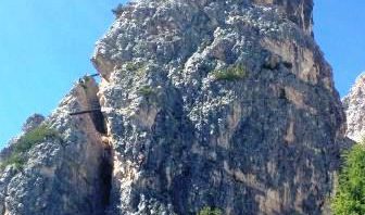
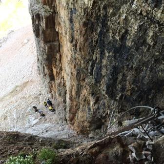
VII Area: Tofane – Pomedes: Via ferrata Ra Bujela sul torrione destro di Pomedes [1,30 di salita, fino al Rif. Pomedes – totale 2 ore – necessaria attrezzatura da ferrata – per esperti]
Percorso:
Da Piè Tofana, cui si giunge in auto, il primo tratto della seggiovia porta in pochi minuti sotto il torrione destro di Pomedes ed all’attacco della via ferrata. Iniziali passaggi esposti, salgono in verticale fino ad un primo ponticello, ove ci si rilassa un pò … quindi alcuni passaggi meno impegnativi portano ad un secondo ponticello … la salita prosegue poi fino alla cima con minore esposizione pur se con qualche passaggio che necessita di un pò di tecnica; la cima domina la vallata (è possibile raggiungere una seconda cima, leggermente più alta, con una breve deviazione di due chidi; qui uno per volta). Quindi una discesa con scaletta e un passaggio orizzontale un pò esposto e arrivo al termine della fatica, praticamente all’altezza dell’inizio dello schuss. (h. 1,30) Da qui al Rif. Pomedes (10 min.), [da cui si può anche proseguire con l’Astaldi, descritto di seguito].
La discesa per la pista da sci e quindi per il sentiero dei camosci (discesa ripida nella parte alta della pista da sci, poi tra i mughi sotto costa, ed infine nel bosco, ancora ripida) che scende costeggiando la montagna e giungendo, dopo circa due ore, a Più Tofana (h 2/2,15).
Valutazioni: ferrata piuttosto impegnativa nella parte inziale perchè verticale; certamente non si deve avere paura del vuoto; di soddisfazione per il panorama (il 25.8.16)
[total 2 hours – necessary equipment for via ferrata – for experts] – path: From Piè Tofana, which can be reached by car, take the chair-lift and in a few minutes will arrive under the right tower of Pomedes and the attack of the via ferrata. Initials exposed passages, rise vertically up to a first bridge, where is possible to relaxes a bit … then some less demanding passages lead to a second bridge … the climb then continues up to the top with less exposure although with some passage that requires a bit of technique; the summit overlooking the valley (you can reach a second peak, slightly higher, with a short detour; here one at a time). Then a descent with ladder and a horizontal passage a little exposed and arriving at the end of fatigue, virtually at the start of the “schuss”. (h. 1.30) From here to Ref. Pomedes (10 min.), [From which you can also continue with the Astaldi, described below]. The descent to the ski slope and then the trail of the chamois going down along the mountain and is reached after about two hours, Piè Tofana (h 2 / 2.15). – ratings: quite challenging in the first part because initial vertically; surely you should not be afraid of the void; satisfaction for the view (done on 8/25/16).
§ § §
VIII Area: Tofane – Pomedes: Via ferrata Ra Pegna sul torrione sinistro di Pomedes [1 ora di salita – totale 1,30 ore – necessaria attrezzatura da ferrata – difficoltà media]
Area: Tofane – Pomedes: Via ferrata Ra Pegna on the left tower of Pomedes [1 hour ascent – total 1.30 hours – via ferrata equipment required – medium difficulty]
Percorso: Da Piè Tofana (m. 1676), dove si giunge in auto, e preso il primo tratto della seggiovia fino al Rifugio Duca d’Aosta (m. 2098) un breve sentiero porta in pochi minuti sotto il torrione sinistro di Pomedes ed all’attacco della via ferrata. L’avvio è all’interno di un canalino e sale senza difficoltà fino ad una prima cengia che si supera verso destra; quindi, sullo spigolo, alcuni chiodi esposti salgono in verticale fino ad una nuova cengia verso sinistra (anch’essa piuttosto esposta) … quindi la salita prosegue fino alla cima con minore esposizione; la cima domina la vallata. La discesa è ancora ferrata per balzi semplici tra stelle alpine, fino ad una scala di 24 pioli che porta al termine della fatica, praticamente all’altezza dell’inizio dello schuss. Da qui al Rif. Pomedes (15 min.) [da cui si può proseguire per altre passeggiate].
Valutazioni: ferrata di medio impegno per il passaggio sullo spigolo; piuttosto breve ma certamente non si deve avere paura del vuoto; di soddisfazione per il panorama (effettuata il 25.8.22)
Route: From Piè Tofana (m. 1676), where you can arrive by car, and taking the first section of the chairlift up to the Duca d’Aosta Refuge (m. 2098) a short path leads in a few minutes under the left tower of Pomedes and at the start of the via ferrata. The start is inside a gully and climbs without difficulty up to a first ledge which you pass to the right; then, on the edge, some exposed pegs climb vertically up to a new ledge to the left (also quite exposed) … then the climb continues to the top with less exposure; the top dominates the valley. The descent is still via ferrata for simple jumps between edelweiss, up to a ladder of 24 rungs that leads to the end of the effort, practically at the height of the start of the schuss. From here to Rif. Pomedes (15 min.) [From which you can continue for other walks]. – via ferrata of medium difficulty for the passage on the edge; rather short but certainly you shouldn’t be afraid of emptiness; satisfaction with the panorama (carried out on 25.8.22)
§ § §
IX Area: Tofane – Pomedes / Rozes: 1) Sentiero ferrato Astaldi e 2) Via ferrata della Grotta di Tofana [intera giornata – necessaria attrezzatura da ferrata; le due vie possono essere fatte separatamente (in circa 4/5 ore per ciascuna); l’Astaldi più facile; la Grotta di Tofana più impegnativa.
Percorso:
1)-si giunge con l’automobile a Piè Tofana e da qui con la seggiovia fino al Rif. Pomedes;
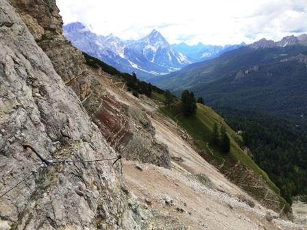
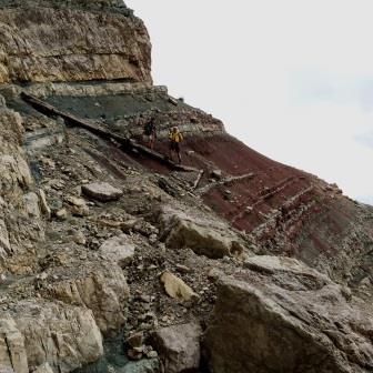
 -dal Rif. Pomedes si scende sulla sinistra per sent. 421 e, dopo aver perso un po’ di quota, si devia sulla destra per il sentiero ferrato Astaldi che si sviluppa in quota in modo spettacolare; non difficile tecnicamente ma non bisogna soffrire di vertigini poichè il sentiero è esposto; (1,5 h);
")
–il sentiero termina al ghiaione della Tofana di Rozes e:
i)si prende sent. 403 sul ghiaione per scendere (m. 2043 slm) fino al Rif. Dibona (20-30 min; effettuata il 20.8.15). Da qui possibile ritorno a Piè Tofana con il sentiero 405 che si diparte dal rifugio Dibona e scende; al secondo bivio sulla sinistra deviazione che appunto riporta -sempre nei boschi- a Piè Tofana (1h – effettuata il 12.8.19);
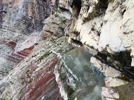
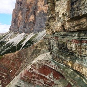
2) Grotta di Tofana: ii) se si vuole fare provenendo dall’Astaldi, si sale per il sentiero 403 (Alta Via n. 1) ove si arriva, verso il Rif. Giussani; si sale per circa 15 min.; poco dopo si prenda il 404 (verso il Castelletto), sulla sinistra; si rimane circa in quota fino ad un incrocio con un sentiero che dalla sinistra viene dal Rif. A.Dibona (che è numerato ancora 403); dritto si prosegue verso il Castelletto; a destra si prende un sentiero non segnato ma visibile che porta alla ferrata della Grotta di Tofana; iii) se si vuole fare come gita “singola” dal Rif. A. Dibona, ben si può lasciare quivi la automobile (la strada è -ad oggi- sempre aperta in periodo estivo), salendo per strada prima asfaltata poi sterrata. Dal Rifugio (m. 2037 s.l.m.) si prende il sentiero 403 e si mantiene la sinistra; il sentiero si biforca; sulla destra un sentiero largo sale al Giussani; sulla sinistra tra mughi, il “nostro” sentiero sale e raggiunge quota 2.300 circa. Il sentiero incrocia il n. 404 che va attraversato per prendere sulla sinistra un sentiero non segnato (dinanzi a noi una piccola targa ricorda caduti della guerra nel 1916). A questo punto si costeggia la Tofana salendo per breve ghiaione, fino a giungere a costeggiare la roccia; proseguendo ancora in salita, il sentiero gira verso destra salendo ancora (su ghiaione franato) ed entrando nella Tofana, fino all’attacco della ferrata (20 min.). La Ferrata sale sulla prima costa della Rozes e rimane in quota; salvo un paio di passaggi in cui si necessita di un pò di tecnica è tecnicamente facile ma non bisogna soffrire di vertigini poichè è esposta; tre tratti di corda portano con un’ultima salita all’antro naturale, alto fino a 10 metri (20 min.). La Grotta -pur con attenzione per il terreno scivoloso e con una necessaria torcia- è molto grande e può essere percorsa nella sua interezza grazie ad un percorso attrezzato che fa prima salire e poi ridiscendere in altra cavità, che se percorsa per intero riporta all’entrata della Grotta medesima (20/30 min anche per vederla bene). Molto interessante e certo niente claustrofobia: il buio è intenso e sopra di noi circa 1000 metri di roccia. La ferrata si riprende poi nello stesso senso; attenzione solo ad eventuali incontri con persone che dovessero percorrere la ferrata in senso opposto; il consiglio è andare presto di mattina (in tutto 2 h, comode, circa); 
–il ritorno è per gli stessi sentieri (404 e/o 403) per il Rif. Dibona (45 min.);
-dal Rif. Dibona:
a) si scende a Piè Tofana per sent. 403 e poi 405 (1,5 h) [effettuata 24.8.07].
b) si riprende il sent. 404 e, ancora costeggiando la Tofana di Rozes, si giunge fino a forcella Col dei Bos, da cui la discesa su Cason de Rozes (sent. 402; 2,5 h) [effettuata 22.8.97].
c) se si ha la macchina al Rifugio Dibona semplicemente si riprende.
Valutazioni: il Sentiero Astaldi porta in un atmosfera incredibile, offrendo una gita bellissima poiché si è immersi in formazioni rocciose di colori incredibili – estremamente panoramica – necessaria assenza di vertigini poiché il sentiero, pur se tecnicamente facile, è esposto – necessaria attrezzatura da ferrata
– La ferrata alla Grotta necessita invece di maggiore tecnica pur non essendo difficile; sono necessarie le torce per permettere visione e passeggiata all’interno della grotta dove c’è un sentiero attrezzato piuttosto sdrucciolevole – la seconda opzione nel finale allunga di molto la gita e rende più difficoltoso il ritorno.
Area: Tofane – Pomedes / Rozes: Astaldi assisted path and Grotta di Tofana via ferrata [whole day – about five hours of walking – via ferrata equipment required]
Route: -Park the car at Piè Tofana and from here take the chairlift to Pomedes Refuge; – From Pomedes Refuge go down a path on the left (no. 421) and, after dropping a bit in altitude, turn to the right to reach the Astaldi assisted path, which runs along at about the same altitude and is spectacular (2 h); –the path ends on the Tofana di Rozes scree, where you can: i)Take path no. 403 on the scree going down as far as Dibona Refuge (30 mins); from here it is possible to return to Piè Tofana with path 405 which branches off from the Dibona refuge and descends; at the second junction on the left deviation that just brings -always in the woods- to Piè Tofana (1h – carried out on 12.8.19); 2) Ferrata Grotta di Tofana: ii) if you want to do it coming from Astaldi, go up path 403 (Alta Via n. 1) where you arrive, towards the Giussani Refuge; go up for about 15 minutes; shortly after, take the 404 (towards Castelletto), on the left; you remain approximately at altitude up to an intersection with a path that comes from the A.Dibona Refuge on the left (which is still numbered 403); straight on, continue towards the Castelletto; to the right, take an unmarked but visible path that leads to the Grotta di Tofana via ferrata (see below); iii) if you want to do it as a “single” trip from Ref. A. Dibona, you can leave your car there (the road is -today- always open in the summer), going up the road first paved and then dirt. From the Refuge (2037 m a.s.l.) take path 403 and keep to the left; the path forks; on the right a wide path climbs to Giussani; on the left among mountain pines, “our” path climbs and reaches an altitude of about 2,300. The path crosses the no. 404 which must be crossed to take an unmarked path on the left (in front of us a small plaque commemorates war dead in 1916). At this point you skirt the Tofana going up a short scree, until you come to skirt the rock; continuing uphill, the path turns right going up again (on collapsed scree) and entering the Tofana, up to the start of the via ferrata (20 min.). The Ferrata climbs the first coast of Rozes and remains at high altitude; except for a couple of passages in which a bit of technique is needed, it is technically easy but one must not suffer from vertigo as it is exposed; three stretches of rope lead with a last climb to the natural cave, up to 10 meters high (20 min.). The Grotto -albeit with attention to the slippery ground and with a necessary torch- is very large and can be covered in its entirety thanks to an equipped path that first leads you up and then back down into another cavity, which if covered in its entirety takes you back to the entrance to the cave itself. Very interesting and certainly not claustrophobic: the oxen is intense and above us about 1000 meters of rock. The via ferrata then resumes in the same direction; attention only to any encounters with people who may have to travel the via ferrata in the opposite direction; the advice is to go early in the morning (about 2 hours in total);
– Return by the same path to Dibona Refuge (45 mins); – From Dibona Refuge: a) Descend to Piè Tofana by path no. 403 and then 405 (1h30) [carried out on 24.o8.07]. – b) Continue on path no. 404 and, still skirting Tofana di Rozes, you will get to Col dei Bos pass, from which you descend to Cason de Rozes (path no. 402; 2h30) [carried out on 22.08.97].
Assessment: The atmosphere on the Astaldi Path is hard to believe. It offers you a wonderful trek because you are surrounded by rock formations with incredible colours – extremely fine views – you need a head for heights as the path, even if technically simple, has some steep drops – via ferrata equipment required. – The Grotta via ferrata instead requires a greater technical capacity even if it is not difficult; you need torches to be able to see and walk inside the cave, where there is a rather slippery assisted path. The second option in the final section makes the walk much longer and makes getting back harder.
§ § §
X Area: Tofane – Cima Tofana di Rozes [intera giornata – sette ore di cammino; per esperti ed allenati]
 Percorso:
-si giunge al Rif. Dibona in automobile dove si parcheggia e da qui si procede a piedi;
-da qui si sale al Rif. Giussani, su sentiero molto battuto ma su ghiaione piuttosto ripido (sent. 403; 550 m. di dislivello in salita; 1,15/1,30 h);
-da qui si prende il sentiero per Cima Rozes, che sale fino alle Tre Dita (ove giunge da altra via, la ferrata Lipella) a circa 3.000 m. s.l.m.;
 -da qui l’ultimo tratto di sentiero piuttosto esposto che porta alla vetta della Tofana di Rozes a m. 3.225 (dal Giussani, circa 700 m. di dislivello in salita; 2,5/3 h);
– ritorno per lo stesso sentiero al Rif. Dibona (3 h).
Valutazioni: Dovendo salire fino alla cima, che, ovviamente, è esposta e molto ventosa, è necessario un tempo bello ed una partenza all’alba, sia per la temperatura e dunque per la fatica, sia per non avere nuvole in vetta ed una cattiva visibilità che potrebbe nascondere il sentiero (in tale ipotesi si deve tornare indietro) – Si necessita di passo sicuro e assenza di vertigini nonché, per il dislivello in salita ed in discesa, di un buon allenamento – la cima, con grande croce, fornisce sensazioni uniche ed entusiasmanti che rimangono indelebili nella mente; il suggerimento, per godere l’ambiente, è di essere in pochi e omogenei nel passo [effettuata 13.8.90; 20.8.93].
Area: Tofane – Cima Tofana di Rozes [whole day – seven hours of walking]
Route: -Park at Dibona Refuge and from here continue on foot; – Climb up to Giussani Refuge, on a path where there is a lot of traffic but passing over a rather steep scree (path no. 403; 550 m. increase in altitude; 1h15/1h30); -From here take the path for Cima Rozes, which climbs up to Tre Dita (where you meet the Lipella via ferrata coming from another direction) at about 3,000 m. above sea level; -From here the last stretch of the path has some rather steep drops and takes you to the top of Tofana di Rozes at 3.225 m. (from Giussani refuge about 700 m. increase in altitude; 2h30/3h00); – Go back the same way to Dibona Refuge (3h).
Assessment: Given that you need to get to the top, which is of course exposed and very windy, this needs to be done with good weather and you also need to leave at dawn, both because of the cold temperature and therefore the risk of fatigue, and also in order to not find clouds at the top and a poor visibility, which could conceal the route (in which case you should turn back) – You need a steady step and a head for heights and, not least, given the difference in altitude both going up and coming down, you need to be pretty fit – the summit, with a big cross, provides some unique, thrilling and unforgettable sensations; a suggestion: to enjoy the surroundings it is better to be only a small group, with a similar walking speed [carried out on 13.08.90; 20.08.93].
§ § §
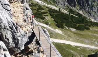
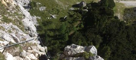
XI Area: Tofane – Rozes / Col dei Bos – Ferrata della Galleria del Castelletto [intera giornata – quattro ore circa di cammino – necessaria attrezzatura da ferrata]
I percorsi di avvicinamento sono due:
a) si giunge al Rif. Dibona in automobile dove si parcheggia e da qui si procede a piedi;
-si prende sentiero 403 in direzione del Rif. Giussani (45 min.), fino ad un bivio sulla sin. per sent. 404, per la Grotta di Tofana; -si prosegue invece e si costeggia la base della Tofana di Rozes fino all’attacco per la ferrata della Grotta di Tofana (che se si vuole si può fare come variante);
ovvero
-si prende direttamente il sentiero 404, che sale diagonalmente ed in modo ripido, fin sotto la Tofana di Rozes (45 min.);
a questo punto si prosegue sul sentiero 404, in costa, fino al segnale dell’attacco della Ferrata del Castelletto, cui si giunge prendendo un bivio in salita sulla destra, fino alla roccia (15 min);
b) si lascia l’automobile a Cason de Rozes, sulla strada per il Falzarego e non molto dopo il bivio per il Rif. Dibona;
-si sale a piedi alla forcella Col dei Bos (sent. 402; 500 m. di dislivello in salita; 1,5 h);
– poi salita per sent. 404, alla Ferrata del Castelletto Galleria;
* L’attacco della Galleria è ripido ma aiutato da scalette; quindi si entra nella Galleria che è in forte salita; l’interno, buio, sale anche con scalini in modo piuttosto ripido; dopo circa 15 min., si supera una apertura sulla destra (che porta al Castelletto, ma qui il sentiero non è più segnato) e si prosegue per qualche minuto fino all’uscita sulla parete della Tofana; da qui brevemente si scende in ghiaione.
Terminata la Galleria si scende per tracce di sentiero, e si aggira il Castelletto -tramite un sentiero in parte attrezzato- verso la Val Travenanzes, e da qui brevemente alla Forcella Col dei Bos (1,5 h).
Il ritorno è per il sentiero 404 (1,5 h).
Valutazione: la Galleria è molto interessante; panoramico l’avvicinamento; belli i baraccamenti ben conservati, anche in Val Travenanzes – necessita di attrezzatura da ferrata, passo fermo e di lampade [effettuata 7.8.15].
Area: Tofane – Rozes / Col dei Bos –Castelletto Tunnel Via Ferrata [whole day – about four hours of walking – via ferrata equipment required] — To get to the via ferrata there are two routes: – a) Park at Dibona Refuge and from here continue on foot; – Take path no. 403 in the direction of Giussani Refuge (45 mins) until you get to a junction on the left for path no. 404, going to “Grotta di Tofana” (Tofana Cave); – Skirt round the bottom of Tofana di Rozes until you get to the start of the Grotta di Tofana via ferrata; – Continue as far as the start of the Castelletto Via Ferrata; b) Park at Cason de Rozes, on the road for the Falzarego Pass and not long after the junction for Dibona Refuge; – Climb on foot to the Col dei Bos Pass (path no. 402; 500 m. of increase in altitude; 1h30); – Then continue going up by path no. 404 to the Castelletto Tunnel via ferrata; – After the Tunnel descend following traces of a path as far as Col dei Bos Pass and return to the start from here. – Assessment: The Tunnel is very interesting for the well-preserved huts of First World War – requires via ferrata equipment, a steady step and torches.
° ° °
XII Area: Tofane – Rozes / Col dei Bos Via Ferrata Lipella –[intera giornata – otto ore circa di cammino – necessaria attrezzatura da ferrata – per esperti]
Percorso
Si lascia l’automobile a Cason de Rozes, sulla strada per il Falzarego e non molto dopo il bivio per il Rif. Di Bona;
-si sale a piedi alla forcella Col dei Bos (sent. 402; 500 m. di dislivello in salita; 1,5 h);
– poi salita per sent. 404, alla Ferrata del Castelletto Galleria;
– all’uscita della Galleria, invece di deviare a sin. per il Col dei Bos, si prosegue per la Via Ferrata Lipella che sale per la parete della Tofana di Rozes (dal lato della Val Travenanzes), e giunge alle Tre Dita a circa 3.000 m. s.l.m.;
-da qui l’ultimo tratto di sentiero piuttosto esposto che porta alla vetta della Tofana di Rozes a m. 3.225 (45 min);
-ritorno al Rif. Giussani, e quindi al Rif. Di Bona (2/3 h).
Valutazione: Gita spettacolare che sale –per un tratto- a precipizio sulla Travenanzes; è ferrata difficile per la quale serve assoluta assenza di vertigini, buon allenamento e forma fisica, anche per la sua lunghezza.
Area: Tofane – Rozes / Col dei Bos Lipella Via Ferrata –[whole day – about eight hours of walking – via ferrata equipment required– for experts] — Route: – Park at Cason de Rozes, on the road for the Falzarego Pass and not long after the junction for Dibona Refuge; – Climb on foot to the Col dei Bos Pass (path no. 402; 500 m. of increase in altitude; 1h30); – Then continue going up by path no. 404 to the Castelletto Tunnel via ferrata; – When you come out of the tunnel, instead of turning left for Col dei Bos, continue on the Lipella Via Ferrata, which climbs up the face of Tofana di Rozes (from the Val Travenanzes side), and you will come to Tre Dita at about 3.000 m. above sea level; – From here there is a final stretch of path with some rather steep drops which takes you to the summit of Tofana di Rozes at 3.225 m altitude (45 mins); – Return to Giussani Refuge and then to Dibona Refuge (2/3 h). – Assessment: Spectacular walk with a section that climbs with a sheer drop over the Travenanzes valley; the via ferrata is difficult, so that a head for heights and a good level of training and physical fitness are absolutely essential, not least because it is long.
§ § §
XIII Area: Tofane – Col dei Bos [intera giornata o di notte – gita per tutti – da una a tre/quattro ore ; si veda anche la sez. Falzarego]
Percorso:
a) si giunge (sulla strada del Falzarego, prima del Col Gallina) alla Capanna Strobel in automobile e qui si parcheggia;
") -quindi a piedi verso Col dei Bos (m. 2303 slm): salita ed al bivio Boscato sulla destra si segue il sentiero 423, fino ai baraccamenti italiani della 1° Guerra Mondiale (il noto Ospedale del 1917); ritorno per la stessa strada (1,5 h complessive)
-quindi a piedi verso Col dei Bos (m. 2303 slm): salita ed al bivio Boscato sulla destra si segue il sentiero 423, fino ai baraccamenti italiani della 1° Guerra Mondiale (il noto Ospedale del 1917); ritorno per la stessa strada (1,5 h complessive)
b) si parcheggia al Cason de Rozes sulla strada per il Falzarego (m. 1843 slm); la comoda e graduale salita per carrareccia (sent. 402), giunge al bivio per sent. n. 423; qui 1) la possibilità di girare a sinistra per giungere seguendo appunto il n. 423 con carrareccia in salita ai baraccamenti italiani (il noto Ospedale del 1917) di cui alla lett. a) che precede; 2) proseguire la carrareccia in salita, passando attraverso la galleria del 1917 fino ad una prima terrazza; poi il sentiero sale ancora verso la forcella Col dei Bos (m. 2303 s.l.m.; sent. 402); poco sotto la forcella, salendo a sinistra, baraccamenti ben mimetizzati cui si accede con tracce di sentiero che meritano una visita [500 m. di dislivello in salita e poi in discesa (2,5 h complessive);
c) si parcheggia al Cason de Rozes sulla strada per il Falzarego; la salita alla forcella Col dei Bos per sent. 402; 500 m. di dislivello in salita (vedi descrizione che precede) – poi sent. 404 in quota sotto Tofana di Rozes – sent. 403 discesa al Rif. Dibona (in questo caso organizzare automobili per il ritorno).
")
Valutazioni: Lo scenario è bello ed alla forcella si ha un bel panorama sul Lagazuoi e sulla valle sottostante – belli anche i baraccamenti [effettuata di giorno 17.8.90; 20.8.94; 21.7.99; 25.8.01; b) 18.8.15; 8.8.19; 24.8.20; 2.6 e 10-8.21, 16.8.23; con deviazione verso l’ospedale del 1917 (b1) il 23.10.20, in splendida cornice innevata e il 9.8.23].
 Il massimo per Col de Bos è by night (o all’alba) perché la gita in notturna ha un altissimo contenuto emotivo e, immersi nel silenzio, pare di camminare in un mondo dove si è ospiti – ognuno fa le riflessioni che ritiene ma si rimane ammirati dalla bellezza della notte specie qui sotto le rocce della Tofana, con chiari colori e forme sorprendenti – un panorama notturno bellissimo, alcune volte con tappeti di nubi al di sotto di noi – la strada fino alla forcella è carrozzabile cosicché, se effettuata con la luna, l’ascesa non necessita di torce (che è comunque opportuno portare, ed accendere all’occorrenza; è necessario abituare gli occhi al buio, per vedere come gli animali, altrimenti la magia e le opportunità di incontri appunto con animali, cessa) – frequentissimi incontri con camosci, marmotte e volpi – la prosecuzione al Dibona consente una visuale sulla valle più ampia e emozioni più lunghe [effettuata il 8.8.89 all’alba; effettuata nella notte tra il 20 ed il 21 agosto 1994 dalle 10,15 alle 01.15, quando si è visto il leggendario “volto di Rozes”, con una indimenticabile esperienza; il 25.8.01, di notte senza luna ma con molte stelle; il 26.8.12 dalle 23 alle 02, con tutta la famiglia e con camosci: splendide sensazioni con una luna che illuminava a giorno specialmente una volta in sella].
Area: Tofane – Col dei Bos [whole day or at night – walk for everybody – three/four hours ]
Possible routes: a) Park at “Capanna Strobel” (Strobel Hut; on the right to Falzarego Pass, just before Col Gallina Refuge); – Then on foot towards Col dei Bos: climbing till “bivio Boscato”, take the right on path no. 412 reach the Italian huts (1st World War); return from the same route (1h30, in total); – b) Park at Cason de Rozes on the road going to the Falzarego Pass and climb to the Col dei Bos on path no. 402; 500 m. increase in altitude and then descending (2h30 in total); – c) Park at Cason de Rozes on the road going to the Falzarego Pass and climb to the Col dei Bos on path no. 402; 500 m. increase in altitude (1h30); – then path no. 404 staying at about the same altitude under Tofana di Rozes – by path no. 403 descend to Dibona Refuge (in this case organise car for going back). – Assessment: Nice scenery and a good view at the pass – the huts of the 1st world war are interesting too [carried out, in the day-time, on 17.08.90; 20.08.94; 21.07.99; 25.08.01]. – But the best way to visit Col de Bos is by night (or at dawn) because a night trek here is very stimulating and, in the midst of the silence, it is like walking in a world where you are a guest – everyone can think as he likes but one remains stunned by the beauty of the night especially here below the rocks of the Tofana, with their light colours and surprising shapes- a really beautiful night scene, at times with carpets of cloud below us – the route to the pass is a track so that, if carried out with moonlight, the climb does not require torches (which, however, it is better to take with you and turn on if necessary; one needs to accustom one’s eyes to the dark, to see like the animals, otherwise there is no more magic and no more possibility of meeting, precisely, animals) – you will very frequently come across chamois, marmots and foxes – the continuation as far as Dibona Refuge provides a more panoramic view of the valley and more long-lasting sensations [carried out on 08.08.89 at dawn; carried out at night between 20.08.94 and 21.08.94 from 10.15 p.m. until 1.15 a.m., when we saw the legendary Rozes “Face”, an unforgettable experience; on 25.08.01, at night without a moon but with a sky full of stars; on 26.08.12 from 11.00 p.m. to 2.00 a.m. with the whole family and the company of chamois: wonderful sensations with a moonlight that made it seem like day-time, especially once we were at the pass].
§ § §
XIV Area: Tofane – Via Ferrata degli Alpini a Col dei Bos [intera giornata – quattro ore di cammino – necessaria attrezzatura da ferrata – per esperti]
Percorso:
– si giunge (sulla strada del Falzarego, prima del Col Gallina) alla Capanna Strobel in automobile e qui si parcheggia;

-quindi a piedi verso Col dei Bos: salita ed al bivio Boscato sulla destra si segue il sentiero 412, fino ai baraccamenti italiani della 1° Guerra Mondiale;
verso Col dei Bos: salita e bivio Boscato per sentiero 412, ai baraccamenti italiani;
")

-poco oltre c’è l’attacco della ferrata che sale sullo spigolo del Col dei Bos in modo piuttosto verticale e con un solo momento di qualche minuto di pausa a circa metà;
ci sono comunque molti appoggi (dislivello 400 m.; 2,5 h), e si giunge su un bel prato in quota;
")
-si scende poi sulla sin. per sentiero in un canalino –parallelo alla salita- che riporta ai baraccamenti;
")
-da qui nuovamente alla base di partenza.
Valutazioni: Bella ferrata di soddisfazione poiché pur non conquistando una cima è impegnativa, anche fisicamente. Come detto, non ci sono possibilità (se non una) di recupero, essendo sempre piuttosto in verticale. Come tutte le ferrate va fatta presto per evitare l’afflusso. Necessaria ovviamente attrezzatura da ferrata [effettuata 24.8.11].
Area: Tofane – Alpini Via Ferrata to Col dei Bos [whole day – four hours of walking – via ferrata equipment necessary – for experts]
Route: – Park at “Capanna Strobel” (Strobel Hut; on the right to Falzarego Pass, just before Col Gallina Refuge); – Then on foot towards Col dei Bos: climbing till bivio Boscato by path no. 412, as far as the Italian First World War huts; – Shortly after this, is the start of the via ferrata, which goes up a rather vertical escarpment to Col dei Bos and without stopping even if there are quite a few footholds (increase in altitude 400 m.; 2h30), reaching a nice grassy expanse at the top; – Then go down on the left in a little gully –parallel to the climb- which takes you back to the huts; – From here go back to the point where you started.
Assessment: Good and satisfying via ferrata because, even if it does not take you to a summit, it is challenging, including from a physical point of view. As mentioned, there are no possibilities (except one) of leaving en route, as the path is always practically vertical. Like all via ferratas it should be done at an early hour to avoid heavy traffic. Obviously via ferrata equipment required [carried out on 24.08.11].
§ § §
XV – Area Falzarego / Tofane – val Travenanzes (intera giornata – circa sei/sette ore)
Percorso:
L’attacco alla Valle può essere duplice:
i) si sale in automobile dalla strada per il Falzarego e si giunge al Cason de Rozes, ove si lascia la macchina;
-si sale alla forcella Col dei Bos (sent. 402 – 1,5 h) e, giunti in quota, si scende in direzione del Cason (=Malga) Travenanzes (sent. 404 – 1 h);
")
ii) si giunge in automobile al passo Falzarego dove si prende la funivia fino al Rif. Lagazuoi
–da qui si prende il sent. 20 per forc. Lagazuoi (200 m. di dislivello in discesa) e quindi sent. 401 per forcella Travenanzes – discesa per sent. 401 fino al Cason Travenanzes (2 h);
– da qui la via è unica: si segue il sent. 401, che si svolge per tutta la val Travenanzes
– il sentiero sfocia infine nel sent. n. 10/401 che si prende verso a destra (cioè verso valle) e segue, scendendo in Val di Fanes fino a giungere a Ponte Alto;
-il sentiero prosegue fino a Pian de Loa e poi al Centro informazioni della Val di Fanes (per il tragitto in Val di Fanes si rinvia al relativo commento- 4 h dal Cason Travenanzes).
Valutazioni: La Travenanzes per i suoi colori e per il rio che vi scorre, per i suoi panorami tra le Tofane e Fanes è imperdibile – Certo è piuttosto lunga pur se sostanzialmente in discesa – va organizzata la presenza di un’automobile alla Val di Fanes, per la ripresa dei gitanti, essendo l’arrivo distante dalla partenza (effettuata 8.8.88; 11.8.95).
Area Falzarego / Tofane – Val Travenanzes (Travenanzes Valley) (whole day – about six/seven hours )
Route: There are two ways into the Valley: – i) Take the road to the Falzarego Pass and park at Cason de Rozes; – Climb to Col dei Bos Pass (path no. 402 – 1h30) and, when you get to the top, go down in the direction of Travenanzes Cason (“Cason” is a shepherd’s hut) (path no. 404 – 1 h); – ii) Park at the Falzarego Pass and take the cable car to Lagazuoi Refuge; – From here take path no. 20 to Lagazuoi Pass (200 m. decrease in altitude) and then path no. 401 to Travenanzes Pass and down by path no. 401 to Cason Travenanzes (2 h); – From here there is only one route: take path no. 401, which goes along the whole Travenanzes Valley, – At the end the path joins path no. 10/401, which you should take towards the right (i.e. downwards) and follow, descending into the Val di Fanes (“Fanes Valley”) until you reach Ponte Alto; -The path continues as far as Pian de Loa and then the Val di Fanes Information Centre (for the walk in Val di Fanes see the relevant section- 4 h from Cason Travenanzes).
Assessment: For its colours, the stream running through it and its views of Tofane and Fanes the Travenanzes valley cannot be missed – For sure, it is rather long, even if for the most part going down – you need to organize another car in Val di Fanes to get back, given that the end of the walk is far from the start (carried out on 08.08.88; 11.08.95).
§ § §
XVI Area: Tofane – Via ferrata al Col Rosà [intera giornata – cinque ore di cammino – necessaria attrezzatura da ferrata – per esperti]
Percorso: si giunge in macchina al Camping Olimpia a Fiames;
– da qui a piedi, lungo il sent. 471 parallelo al Boite;
 – dopo circa 20 min. si prende sulla sin. verso monte il sent. 408 (tra i boschi) per il Passo Posporcora, che si raggiunge (2 h);
– al Passo si prende sulla destra il sent. 408 verso la Via ferrata Ettore Bovero al Col Rosà;
– la salita è per lo più in verticale con un passaggio in orizzontale molto esposto, sullo spigolo (1 h);
– la discesa segue il sentiero dalla parte opposta; è sentiero normale, piuttosto ripido (sent. 447; 1,5 h) che sfocia poi nel sent. 471 che si segue fino al Camping Olimpia.
Valutazioni: Gita bella ed impegnativa. La ferrata va iniziata molto presto per evitare code essendo in spigolo; piuttosto verticale specie nella prima metà e con un passaggio molto molto esposto; poi gradoni e passaggi attrezzati – necessaria attrezzatura, assenza di vertigini, buona forma fisica ed esperienza. Massima soddisfazione all’arrivo (quel giorno –circa alle 9,00 del 14.8.04- siamo stati i primi in cima, come da libro di vetta).
Area: Tofane – Col Rosà Via ferrata [whole day – five hours of walking – via ferrata equipment necessary– for experts]
Route: Park at the Olimpia campsite in Fiames; – From here go on foot along path no. 471 which is parallel to the Boite Valley; – After about 20 mins take path no. 408 on the left and going up (through woodland) for the Posporcora Pass, which you should reach after about 2 hours; – At the Pass take path no. 408 on the right towards the Ettore Bovero Via Ferrata at Col Rosà; – The climb is for the most part vertical with just one horizontal section above a steep drop and on a corner (1 h); – To go down follow the path on the other side; this is a normal path but rather steep (path no. 447; 1h30) which then joins path no. 471, which you should follow until you reach the Olimpia campsite.
Assessment: Nice and challenging trek. You should start out on the via ferrata very early in the day to avoid queues as there is a sharp edge and the climb is somewhat vertical, especially the first half, and with one section with a steep drop; then steep steps and assisted sections – you will need the correct equipment, a head for heights, a good level of fitness and experience of via ferratas. Very satisfying when you have done it (on the day we did it –at about 9.00 a.m. on 14.08.04- we were the first to get to the top, worthy of mentioning in a summit book).