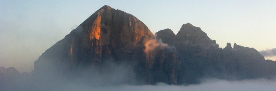
Il Lago di Misurina merita una visita per il suo colore e per la corona di montagne che lo circonda. Tra queste spiccano i Cadini di Misurina, Torri tra loro collegate da ghiaioni e nevai, che possono essere attraversate o lambite con gite per tutti o per esperti.
Lake Misurina is worth a visit for its color and for the crown of mountains surrounding it . Among these Cadini Misurina , towers interconnected by scree and snowfields , which may be crossed or lapped with rides for all or experts .
§ § §
 Area: Cadini di Misurina – Col de Varda / Città di Carpi [intera giornata – per tutti – tre / quattro ore di cammino] full day – for everybody – 3-4 h
Percorso:
– si giunge in macchina al lago di Misurina e si parcheggia arrivando;
-si prende la seggiovia che porta al Rif. Col de Varda e:
i) si scende a piedi su Misurina [1/2 giornata – bambinabile; effettuata 16.8.00]
ii) si prende il sent. 120 [dopo salita al “picco panoramico” –facoltativa], si giunge al Rif. Città di Carpi (poco dislivello complessivo, ma vi è una discesa ed una salita – 1,5 h);
")
–il ritorno può avere due opzioni:
a) per lo stesso sentiero 120, fino al Rif. Col de Varda (1,5 h) e quindi al lago di Misurina (30 min.) [effettuata 7.8.06];
b) si torna sui propri passi sul sent. 120 e, poco dopo, si devia a sin. per sent. sempre n. 120 che diviene poi 1120 (ex 121); con una lunga discesa nei boschi, si giunge all’Albergo Cristallo (750 m. di dislivello) [effettuata 10.8.92].
Valutazioni: Gite di media fatica, tra i boschi; panoramica al Città di Carpi, e, dal Col de Varda, sul lago – la semplice discesa dal Col de Varda a Misurina è anche per i bambini ed è bello vedere il lago dall’alto.
Path: – You come by car to Misurina lake and park coming ; -you take the chairlift to Rif . Col de Varda and : i) it comes down to the foot of Misurina [ 1/2 day – bambinabile ; carried 08/16/00 ] ii ) you take the felt . 120 [ after ascent to the ” peak panoramic ” -facoltativa ] , you reach the Rif . City of Carpi ( fairly level overall , but there is a descent and ascent – 1.5 h -the return can have two options : a) for the same path 120 , to the Rif . Col de Varda ( 1.5 h ) and then to Misurinasee ( 30 min . ) [ performed 08/07/06 ] ; b ) to return to where they started on the felt . 120 and , shortly after , we turn right . sent to . still no. 120 which becomes 1120 (ex 121 ) ; with a long descent in the woods , you come to the Hotel Cristallo ( 750 m . altitude) [ performed 08/10/92 ] .
Ratings: Tours of average difficulty, in the woods ; overview of the City of Carpi , and , from the Col de Varda , the lake – the simple descent from the Col de Varda Misurina is also for children and it is nice to see the lake from above
§ § §
Area: Cadini di Misurina – Rif. Città di Carpi volendo fino Rif. Fonda Savio (sentiero Bonacossa) [intera giornata – tre / cinque ore di cammino – opportuna attrezzatura da ferrata] full day – 3-5 h – set ferrata
Percorso:
– si giunge in macchina al lago di Misurina e si parcheggia arrivando;
 -si prende la seggiovia che porta al Rif. Col de Varda e da qui sulla sinistra, si prende il sent. 117 (“sentiero Alberto Bonacossa”, Alta Via n. 4) e ci si dirige alla Forcella Misurina e, superando un passaggio attrezzato ripido, a quella del Diavolo (200 m. di dislivello; 45 min.);
")
– la discesa è anch’essa ripida ed effettuata anche grazie alle corde fisse del sentiero Bonacossa; si giunge alla sella ove c’è un trivio (30 min):
i) a destra, salendo per il sent. 118, si va sulla sella del Cadin della Neve e da qui si può scendere al Rif. Città di Carpi;
ii) al centro si prosegue per il sentiero Bonacossa giungendo al Rif. Fonda Savio attraverso il Passo dei Tocci, in bellissima posizione al centro del gruppo dei Cadini (1 h); -ritorno per lo stesso sentiero [1,30/2 h; effettuata 11.8.78]
 iii) a sinistra, scendendo per il ghiaione, per il sent. 118 si giunge al bosco, si aggira il Cadin del Diavolo fino a giungere ad un altro bivio sulla sinistra che riporta alla base della seggiovia di inizio gita [1,30 h; effettuata il 14.8.15]
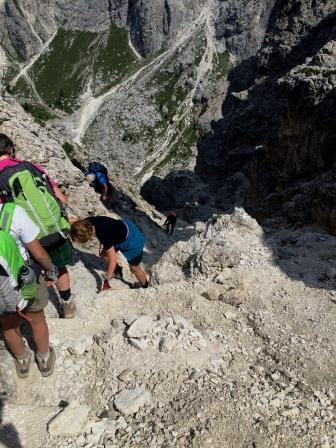
Valutazioni: merita per gustare i Cadini; bellissimo panorama; necessaria attrezzatura da ferrata; il sentiero, pur se non difficile tecnicamente, è però molto scosceso e dunque l’aiuto della corda è necessario.
Path: – You come by car to Misurinasee and park coming ; -you take the chairlift to Rif . Col de Varda and from here on the left , you take the path n . 117 ( ” path Bonacossa ” Alta Via n . 4 ) and head to the Forcella Misurina and, overcoming a passage equipped , to that of the Forcella del Diavolo (200 m . Altitude); the descent is too steep and made thanks to the fixed ropes of the path Bonacossa ; You reach the saddle where there is a crossroads (30 min ) : i) on the right , going up to the felt . 118 , you go on the saddle of the Cadin of Snow, and from here you can descend to Rif . City of Carpi ; ii ) the path in the center continue Bonacossa reaching the ref. Fonda Savio through the Pass of Tocci , beautiful location in the center of the group Cadini ( 1 h) ; -Return to the same path [ 1.30 / 2 h ; carried 11/08/78 ] iii ) to the left , going down the scree, to the felt . 118; arrive into the forest, around the Cadin of Devil until you reach another fork on the left that shows the base of the chairlift start outing [ 1,30 h ; made on 08.14.15 – Ratings: deserves to enjoy the Cadini ; beautiful landscape; necessary equipment set ferrata; the path, although not technically difficult, however, is very steep and therefore, the help of the rope is necessary.
§ § §
 dal popena") Area: Cadini di Misurina – Giro dei Cadini e “sentiero Bonacossa” (Alta Via n. 4) [intera giornata – sette ore di cammino – necessità di attrezzatura da ferrata] full day – 7 h – set ferrata
Area: Cadini di Misurina – Giro dei Cadini e “sentiero Bonacossa” (Alta Via n. 4) [intera giornata – sette ore di cammino – necessità di attrezzatura da ferrata] full day – 7 h – set ferrata
Percorso:
– si giunge in macchina al lago di Misurina e si parcheggia arrivando;
-si prende la seggiovia che porta al Rif. Col de Varda (si sconsiglia la salita a piedi, specialmente se si deve effettuare la gita lunga) e si prende il sent. 120, per arrivare al Rif. Città di Carpi (poco dislivello complessivo, ma vi è una discesa ed una salita – 1,5 h);
")
-dal Rifugio Città di Carpi si sale per sent. 118 verso la Forcella della Neve (circa 700 m. di dislivello), con salita su ghiaione e tratto di sentiero ferrato;
-superata la Forcella si attraversa il nevaio (se ancora presente) all’interno del Cadin delle Neve fino a raggiungere il Rif. Fonda Savio al Passo dei Tocci, in bellissima posizione al centro del gruppo dei Cadini;
-si prosegue poi per il sent. 117 (“sentiero Bonacossa”, Alta Via n. 4), superando la Forcella del Diavolo e poi –dopo sentiero ferrato – la Forcella Misurina;
-si giunge così al Rif. Col de Varda ed alla fine della gita.
Valutazioni: Il Giro dei Cadini è magnifico ma il fatto di dover superare tre forcelle con un forte dislivello, impone di effettuarla in buona forma e allenamento. Le parti attrezzate non sono di particolare difficoltà ma la neve e la stanchezza possono aumentarla [effettuata 11.8.78].
Path: – by car to Misurinasee and park coming ; -take the chairlift to Rif . Col de Varda and take the felt . 120 , to get to the Rif . City of Carpi ( fairly level overall , but there is a descent and ascent – 1.5 h ) ; -from Refuge Città di Carpi go up sent. 118 towards Forcella della Neve ( approximately 700 m . In altitude ) , with slope of scree and stretch of beaten trail ; Forcella -topped cross the snowfield ( if still present ) within the Cadin of Snow up to the Rif . Fonda Savio to Passo dei Tocci , beautiful location in the center of the group of Cadini ; -it continues to sent. 117 ( ” path Bonacossa ” Alta Via n . 4 ) , exceeding the Devil’s Fork and then -after beaten trail – Forcella Misurina ; -you thus comes to Rif . Col de Varda and at the end of the trip .
Ratings: The Giro dei Cadini is magnificent but the fact of having to pass three forks with a steep gradient , requires implementation in good shape and workout . The parts are equipped not particularly difficult but the snow and fatigue may increase it [ performed 11/08/78 ]