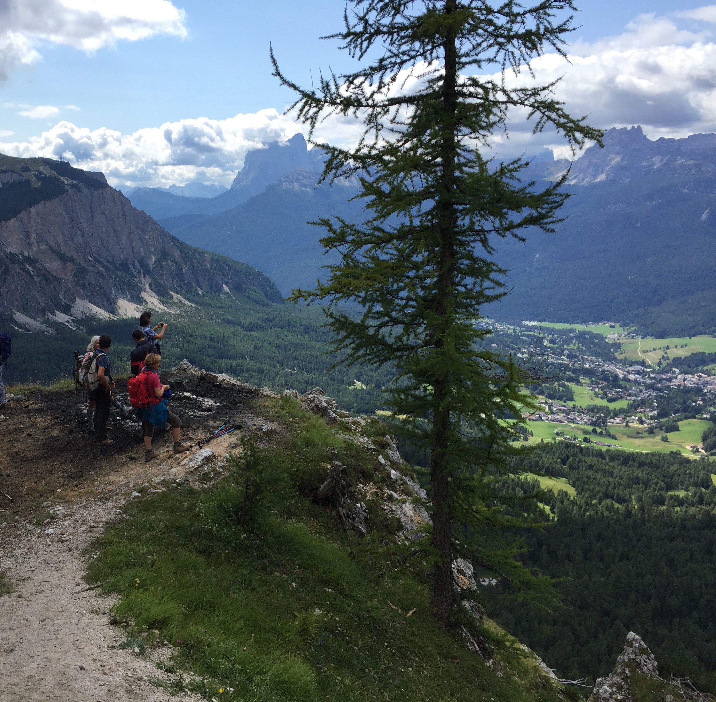
 Il Gruppo del Pomagagnon comprende Mietres e la Val Padeon e presenta gite di diversi livelli: da quelle per bambini e per tutti, a quelle più faticose e a ferrate.
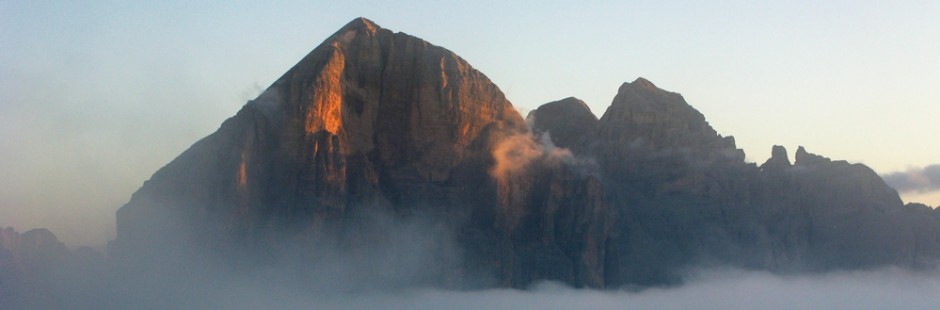
Il Gruppo del Cristallo presenta ferrate ed alcune passeggiate nelle valli che da esso si dipartono (Val Popena, Val Fonda).

The Pomagagnon Group of mountains is comprehensive of Mietres and Val Padeon and offers various types of walk, from ones for children and for everyone, to those harder and with via ferrata.
Cristallo Group offers vie ferrate and some walks that distribute from it.
§ § §
Area: Pomagagnon –Mietres – [bambinabile/per tutti – gite comprese tra una e tre ore di cammino]
Percorsi:
a) partenza da Rif. Col Tondo (m. 1.429 s.l.m.) (cui si giunge a piedi da Guargnè o in automobile da Chiave) e da qui al Rif. Mietres (m. 1.710 s.l.m.) per sent. 204 (45 min.; in salita 290 m. di dislivello) e rit. (40 min.); possibili soste e pic nic sui prati sopra Col Tondo, con vista panoramica.
b) partenza da Guargnè (m. 1.320) e da qui (per sent. 204) al Rif. Col Tondo (m. 1.429 s.l.m.) e al Rif. Mietres (m. 1.710 s.l.m); discesa per lo stesso sentiero (1,30/2 h);
c) partenza da Malga Lareto (m. 1.664 s.l.m.) (sent. 206 e 211) fino al Rif. Mietres (m. 1.710 s.l.m.) – discesa a Col Tondo (sent. 204; complessiva durata di 1,5 h; m. 1.429 s.l.m.) e quindi sino a Guargnè (vedi sopra lett. b);
Valutazioni: Passeggiate tranquille sui prati – gita per bambini (a piedi dai 4/5 anni) – la durata è limitata ma con i bambini può essere un bel modo per passare la giornata, dividendo in due parti la gita; possibilità di pic nic su prati anche fuori sentiero poichè l’area si presta anche per il panorama che si gode [effettuata 17.8.96; 2.7.97; 21.8.98; 14.8.00; 2.8.02; 1.6.21; 12 e 15.8.21; 15.8.23].
Area: Pomaganon/Mietres – [whole day – walk suitable for children –from two to three hours of walking]
Route:
a) Go to the mountain dew Col. Tondo (you can reach it with the chair lift from Guargné or by car) and from there to the mountain dew Mietres with the route 204 (45 min.; 290 m. decrease in altitude) and back (40 min.)
b) Go to Guargné and from there (taking the route 204) to the mountain dew Col Tondo and Mietres (450 m. decrease in altitude); back with the same route (1.30/2 h.)
c) Go to Malga Lareto (route 206 and 211) to the dew Mietres- back to Col Tondo (route 204; last for 1.5 h)
Assessment: easy walks on fields – suitable for children (from 4/5 years) – takes a short time but could be a good way to pass out the day with children, splitting the excursion in two parts [carried out on 17.08.96; 2.07.97; 21.08.98; 14.08.00; 2.08.02; 1.6 e 15.8.21]
° ° °
Area: Faloria / Pomagagnon – Mandres / Mietres [intera giornata – per tutti – gita di circa tre/quattro ore]
Percorso:
– Dall’ex Liceo delle Orsoline (oggi Casa per Ferie; m. 1.305 s.l.m.) di Via Faloria, a Mandres (m. 1.480 s.l.m.; per sent. 210; 45 min.);
– poco prima di Mandres, al bivio, prendere il sent. 206 che sale (200 m. di dislivello) e giunge sulla strada per Passo Tre Croci (che si incrocia a m. 1.624 s.l.m.);
– attraversata la strada, per sent. 206 si giunge a Malga Lareto (m. 1.664 s.l.m.) e quindi per sent. 211 al Rif. Mietres (m. 1.710 s.l.m.);
– dal Rif. Mietres, per la discesa, si vedano le gite descritte subito sopra.
Valutazione: Bella gita tutta nei boschi, poco frequentata specie nella parte centrale (3/3,5 h).
Area: Faloria/ Pomagagnon – Mandres/ Mietres [whole day – for everyone – from three to four hours of walking]
Route:
- From the Orsoline’s ex high school on via Faloria to Mandres (route 206; 45 min; 150 m. decrease in altitude)
- A bit before Mandres, to the fork, take the route 206 that climbs (200 m. decrease in altitude) and reach the street to Passo Tre Croci
- Cross the road reach the route 206 that takes you to Malga Lareto and then through the route 211 to the dew Mietres
- From there, for coming back, look at the route I wrote before.
Assessment: nice walk through the woods, not very popular especially in the central part of the route (3/3.5 h.)
§ § §
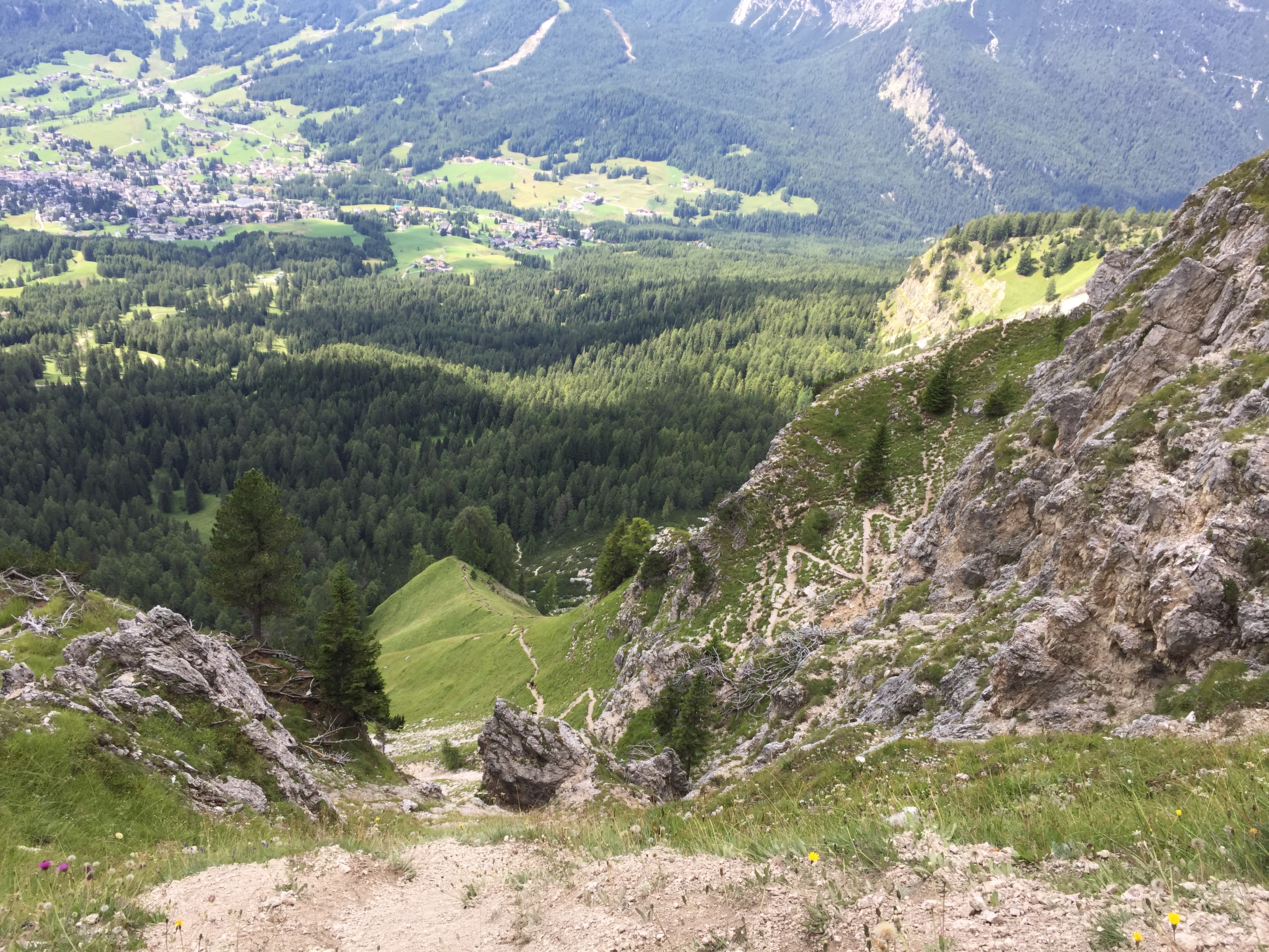
Area: Pomagagnon – Forcella Zumeles e terrazza panoramica [intera giornata – per tutti – gita da 1 ora a 4 a seconda degli itinerari]
Percorso:
-si giunge a Rio Gere ove c’è ampio parcheggio per lasciare l’auto;
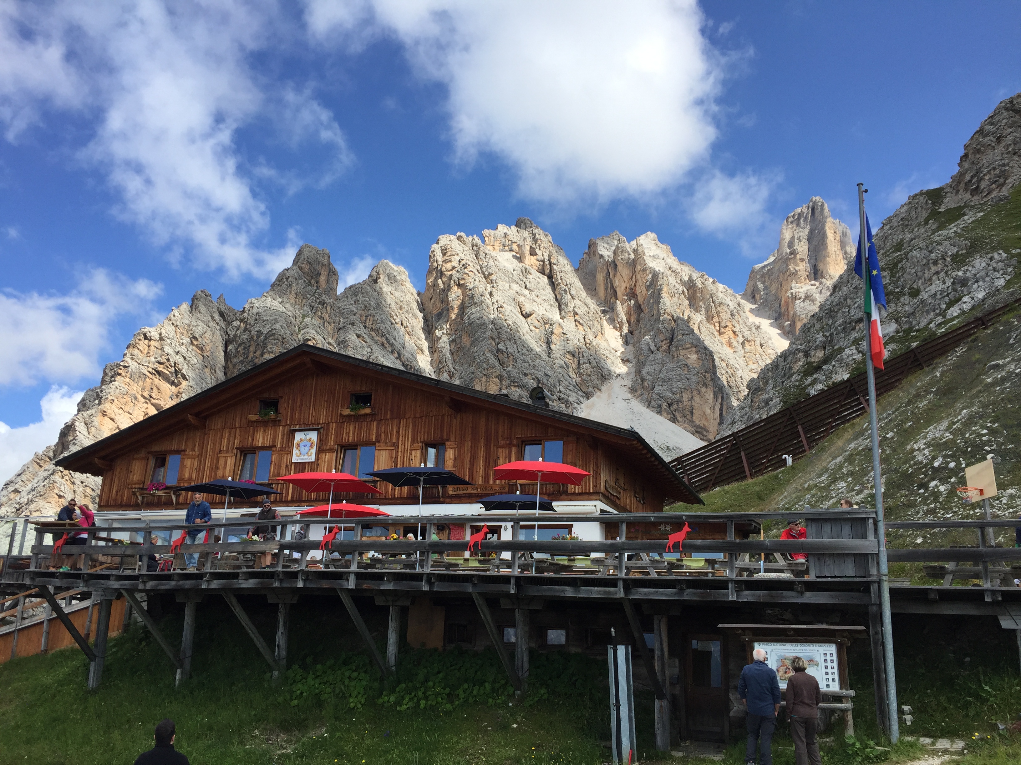
rifugio son forca
-da Rio Gere (m. 1.698 s.l.m.; salita anche in seggiovia) al Rif. Son Forca (m. 2216 s.l.m.); da qui si scende per la pista da sci giungendo alla forcella Son Forca (m. 2.017 s.l.m.); quindi per il sent. 205, sulla destra, in leggera salita nei boschi del Pomagagnon fino a Forcella Zumeles (m. 2.072 s.l.m.);
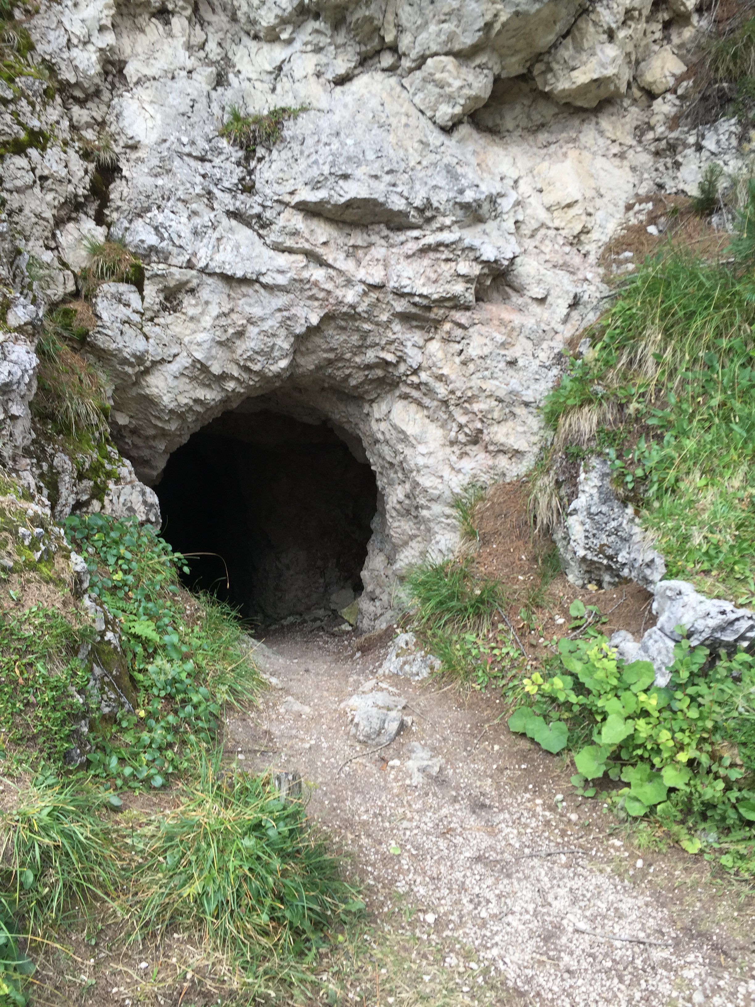
-poco prima della forcella Zuméles, sulla sinistra vi è una stretta apertura: una breve galleria bassa (attenzione alla testa) cui si accede da una piccola piazzola sul sentiero n. 205;
si entri senza timori e, percorsa la galleria (non necessita lampada), si giunge su una ampia terrazza panoramica sulla valle di Cortina (spettacolare; attenzione a non sporgersi);
– da qui il ritorno:
i) si può fare la medesima strada a ritroso; ovvero ii) giunti alla forcella Son Forca (20 min.) scendere a) al Rif. Rio Gere per sent. 203 e poi 206 seguendo la pista da sci; b) al Passo Tre Croci (m. 1.860 s.l.m.), per sent. 203 (200 m. di dislivello); c) il sent. 203, sulla sella si divide; se si prende sulla destra nel bosco il sent. 206 si giunge a Rio Gere (1 ora; m. 1698 s.l.m.); prima molto scosceso, poi sotto alla seggiovia, infine sempre nel bosco, delicato declivio
iii) si può anche scendere dalla forcella Zumeles (sent. 204), per sentiero scosceso e ripido (assenza di vertigini per la parte iniziale) che attraversa le Crepe di Zumeles; giunti nel bosco si prende sulla sinistra il comodo sentiero n. 211 fino al Rif. Mietres (m. 1.710 s.l.m.; circa 1 ora); da qui per il medesimo sentiero si giunge alla Malga de Larieto ed a Rio Gere.
Valutazioni: Facile (nelle prime due versioni) e molto panoramica – splendido pic–nic sulla terrazza naturale che dà sulla valle d’Ampezzo; gita per tutti [per la iii) bisogna avere piede fermo nella prima parte della ripida discesa; durata dalle 2 alle 3 ore a seconda dei percorsi [effettuata ii) a) 1.8.02; ii) b) 15.8.78; c) 26.8.19; iii) 16.8.18; 25.8.25].
Area: Pomagagnon – Forcella Zumelles and the observation platform [whole day- for everyone- it takes two hours and a half approximatly] – Route: -You get to Rio Gere where there is ample parking to leave the car; -from Rio Gere (1,698 m above sea level; ascent also by chairlift) to the Ref. Son Forca (m 2216 s.l.m.); from here you go down the ski slope reaching the Son Forca fork (2.017 m.l.m.); so for the sent. 205, on the right, slightly uphill in the woods of the Pomagagnon up to Forcella Zumeles (2,072 m above sea level); – just before the fork, on the left there is a narrow opening: a short low gallery (attention to the head) which is accessed by a small pitch on path n. 205; you enter in the gallery (does not need a lamp), you arrive on a large terrace overlooking the valley of Cortina (spectacular, be careful not to lean out); – to come back i) the same backward path can be made; or ii) come to the Son Forca fork to go down a) to the Rio Gere ref. 203 and then 206 following the ski slope; b) at the Tre Croci Pass (1,860 m above sea level), per sent. 203 (200 m difference in height); c) the sent. 203, on the saddle divides; if you take on the right in the wood the sent. 206 we arrive at Rio Gere (1 hour; m. 1698 s.l.m.); first very steep, then under the chairlift, finally always in the wood, a delicate slope iii) you can also get off the Zumeles fork (route 204), on a steep and steep path that crosses the Creel of Zumeles; when you reach the forest, take the comfortable path n. 211 up to Rif. Mietres (1,710 m above sea level, about 1 hour); from here along the same path you reach the Malga de Larieto and Rio Gere Assessment: easy and panoramic route – you can have a nice pic-nic at the observation platform that overlook on the Ampezzo Valley.[carried out a) 1.08.02; b) 15.08.78; c) 26.8.19; iii) 16.8.18]
§ § §
Area: Pomagagnon / Cristallo – Val Padeon (intera giornata – gita per tutti – circa tre ore di cammino]
Percorso:
– da Rio Gere al Rif. Son Forca (salita anche in seggiovia; vedi sopra, gita analoga fino alla forcella Son Forca);
– da qui (m. 2017 s.l.m.) la discesa dolce per sentiero 203 comodo nella Val Padeon fino ad Ospitale (m. 1.470 s.l.m. circa; 550 m. di dislivello dalla forcella Son Forca; 3 h).
Valutazione: Gita tranquilla in discesa tra boschi – bella la Val Padeon, che divide il Cristallo dal Pomaganon – opportuna l’organizzazione con due automobili, pur tenendo presente che da Ospitale (sulla strada per Dobbiaco) passa l’autobus per Cortina [effettuata 20.8.00; 20.8.20].
Area: Pomagagnon/ Cristallo – Val Padeon (whole day- route for everyone- approximatly three hours walking) – Route: from Rio Gere to the dew Son Forca (taking the chairlift); from there the slope through Val Padeon till Ospitale (route 203; 550 m. decrease in altitude from the Son Forca’s fork; 3 hours) – Assessment: easy route on a slope across woods – Padeon Valley is nice, divide Cristallo and Pomagagnon- advantageous thinking about two cars, bearing in mind that from Ospitale (on the way to Dobbiaco) there’s a bus to Cortina [carried out on 20.08.00; 20.8.20]
° ° °
Area: Pomagagnon / Cristallo – Ghiaione del Pomagagnon [intera giornata – circa cinque ore di cammino]
Percorso:
– da Rif. Son Forca (salita in seggiovia da Rio Gere) per Val Padeon (sent. 203; vedi gita che precede);
– verso le parte finale della valle (a ca. 1700 m. slm, avendo fatto ca. 300 m. di dislivello in discesa), si lascia il sentiero 203 e si prende sulla sin. il sent. 202 per la Valle Pomagagnon, salendo fino alla forcella Pomagagnon (m. 2.178 s.l.m.; 2,5 h);
– da qui si scende verso la Valle d’Ampezzo per il grande ghiaione e, seguendo lo stesso sent. 202, si giunge al Codivilla. 
Valutazione: La prima parte della gita ripercorre quella della Val Padeon, e si rinvia al relativo commento.
La salita alla forcella Pomagagnon è piuttosto ripida e necessita di una minimo di preparazione fisica, anche considerando il dislivello e la tipologia di sentiero tra mughi – il ghiaione dà sulla Valle d’Ampezzo ed a mio avviso è uno dei più belli dell’area, pur avendo pietre piuttosto grandi cosicchè la discesa a “salti” merita una certa attenzione – è inutile dire che la discesa sui ghiaioni necessita di un minimo di prudenza e di ginocchia buone: solo in queste condizioni (e dunque dove possibile poter “saltare”) è divertente; altrimenti è una sofferenza … – poiché i ghiaioni cambiano molto di anno in anno, è necessario acquisire informazioni presso le Guide di Cortina sul relativo stato prima di partire[effettuata 12.8.82; 6.8.88] .
Area: Pomagagnon/ Cristallo – Ghiaione del Pomagagnon [whole day- five hours of walking approximatly]
Route: – From the dew Son Forca (reach it taking the chairlift from Rio Gere); from there through Padeon Valley (route 203) – Nearby the final part of the slope (1700 m in altitude, 300 m decrease in altutude from Rio Gere) take on the left the route 202 for Pomagagnon Valley, climbing till the Pomagagnon Fork (500 m decrease in altitude; 2.5h); – From there climb down to Ampezzo Valley through the great grave road and, following the route 202, reach the Codivilla Hospital. – Assessment: the first part of the excusion is the same as the Padeon Valley, refere that assessment. – Climbing up the Pomagagnon’s fork is preatty steep, requeres a minimum training, considering the altitude gap and the type of the route, between longleaf pines- the great grave road that look out onto the Ampezzo Valley is, in my opinion, one of the best in the area but because of his big stones, the “jumping” slope requia minuimum of attention- only in this conditions (with also good knees) is funny: in other ways is a physical suffering. The grate stone road changes year by year, so is useful asking for information about his status at the Cortina’s Guides before starting the route. [carried out on 12.08.82; 6.08.88].
§ § §
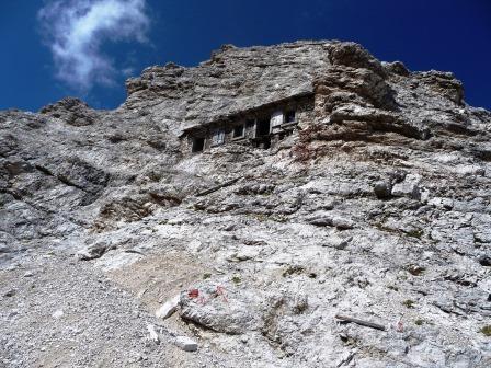
Area: Pomagagnon: Ferrata Michielli Strobel a Punta Fiames [intera giornata – circa cinque ore di cammino – necessaria attrezzatura da ferrata]
Percorso:
– All’altezza dell’Albergo Fiames (m. 1.290 s.l.m.), sulla destra della strada per Dobbiaco, parte il sentiero che sale verso la base del Pomagagnon; si lasci l’automobile al parcheggio dell’albergo o nelle piazzole vicine;
– dopo circa 40 min. di salita (circa m. 1.500 s.l.m.) l’attacco della ferrata;
– con la ferrata si giunge alla cima della Punta Fiames in circa 2/3 h (circa 900 m. di dislivello) ed alla vicina forcella Pomagagnon (m. 2.178 s.l.m.);
– dalla forcella, si scende per il ghiaione del Pomagagnon (sent. 202) e si giunge al Codivilla (su questa parte si rinvia alla gita che precede, Ghiaione del Pomagagnon).
Valutazione: La ferrata è caratterizzata da tratti di corda alternati da tratti di sentiero ripido, il che la rende faticosa perché si può spezzare il fiato, pur se nei tratti di sentiero si allenta la eventuale tensione da ferrata – pur essendo una delle più note e proposte come “prima ferrata”, è invece piuttosto impegnativa ed esposta, sviluppandosi sullo spigolo della cima Fiames sul Pomagagnon – è molto frequentata in agosto, cosicchè è necessario partire molto presto – panorama bellissimo – per il ghiaione si veda la relativa descrizione [effettuata 14.8.81; 14.8.88].
Area: Pomagagnon: Via ferrata Michielli Strobel at Punta Fiames [whole day- five hours of walking approximatly- requires via ferrata equipment] Route: – From Fiames Hotel, on the right of the road, starts the route that climbs up to Pomagagnon – After 40 min. starts the via ferrata – Through the via ferrata reach the top of Punta Fiames (about 2/3 hours and 900 m decrease in altitude) and Pomagagnon’s fork – From the fork, climb down through the Pomagagnon’s great stone road (route 202) and reach the Codivilla Hospital (on this part of the route, refere at the last excusion) Assessement: The via ferrata is characterized by rise and fall with a narrow route, and this makes this route hard- even if is one of the most famous and proposed as the best first via ferrata, is instead particularly hard and expose, developing on the edge of the Fiames peak on Pomagagnon- is well frequented in August therefore is better to start this route early- wonderful view- for the greate stone road look at his description [carried out on 14.08.81; 14.08.88]
§ § §
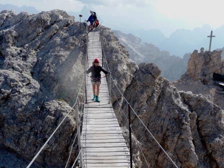
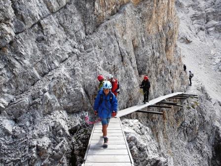
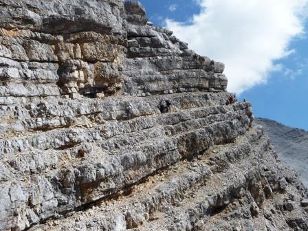
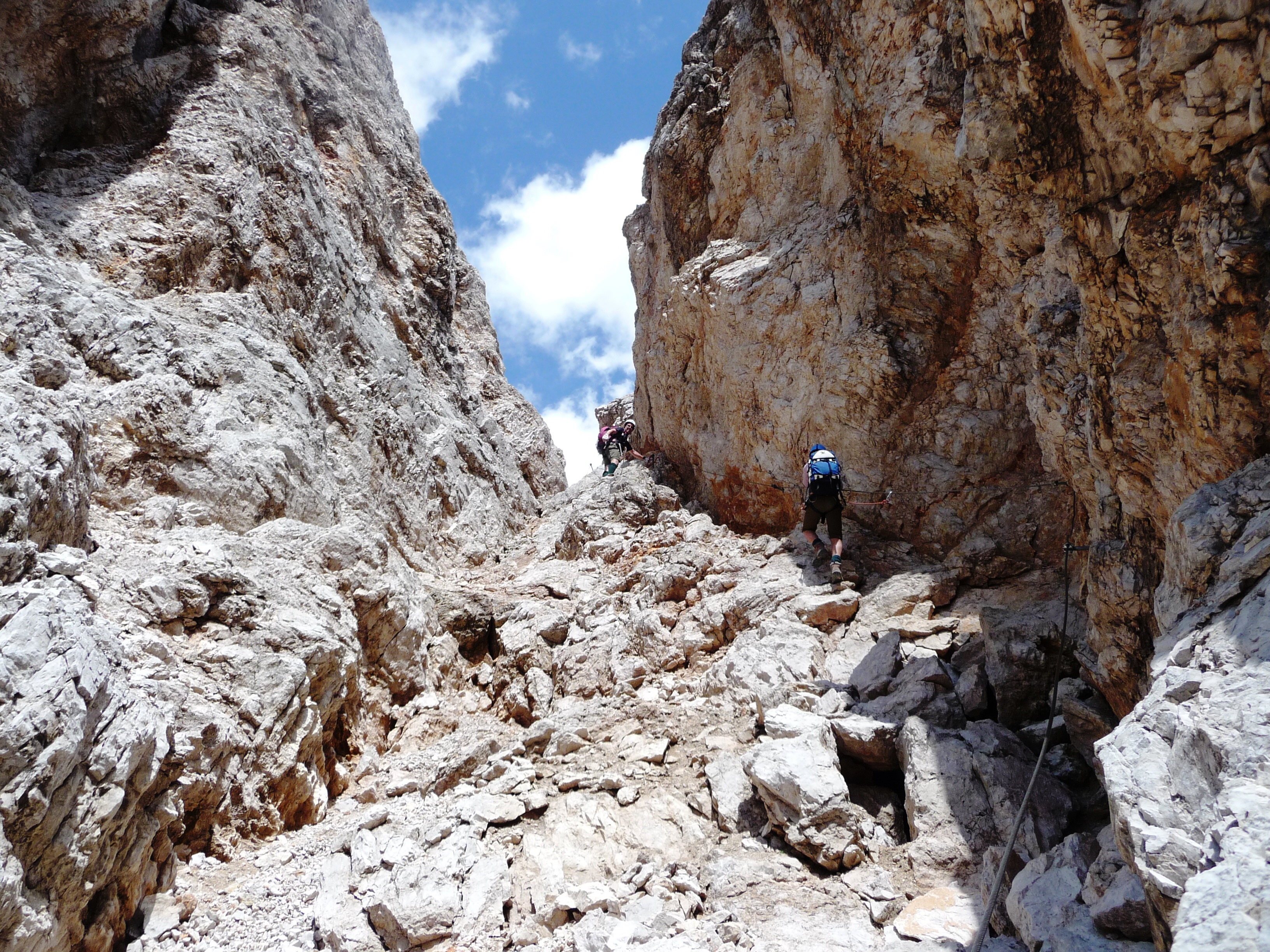
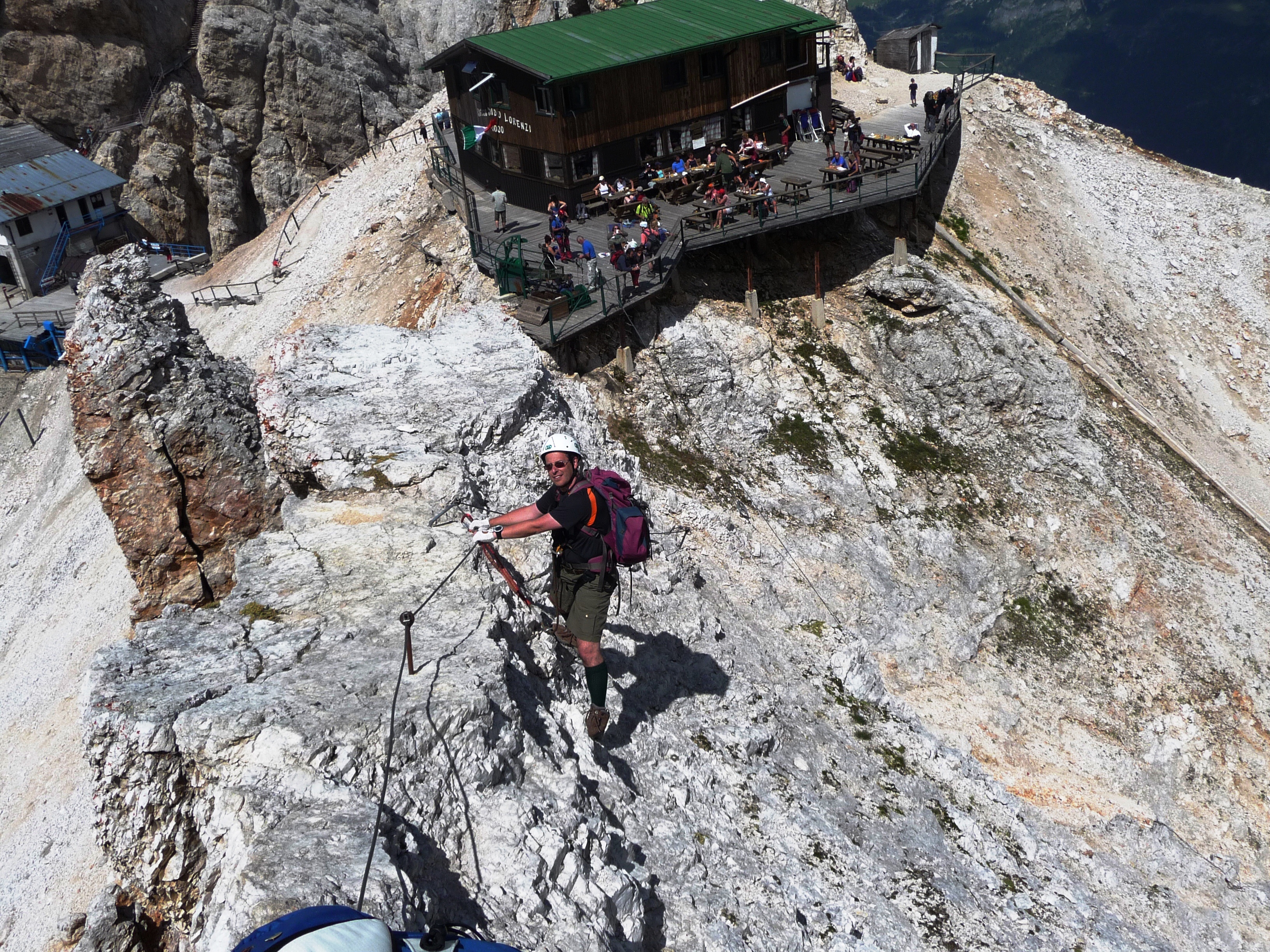
Area: Cristallo: Sentiero ferrato Ivano Dibona (le “creste bianche”) – [intera giornata – sette/otto ore di cammino (senza la salita al Lorenzi da Son Forca)– necessaria attrezzatura da ferrata]
Percorso:
– da Rio Gere, al Rif. Son Forca ed al Rif. Lorenzi (salita in seggiovia; fenomeni atmosferici forti nell’agosto 2017 hanno fermato la seggiovia oggi non più esistente nella tratta Son Forca Lorenzi; si deve quindi salire a piedi da Son Forca (m. 2.216 s.l.m.) fino al Rif. Lorenzi (m. 2.932 s.l.m.) per ripido sentiero su ghiaione; oggi ci sono delle varianti per attaccare il sentiero da quota più bassa; acquisire informazioni sull’accessibilità e sullo stato dei sentieri);
– dalla fine della ex seggiovia alcuni scalini portano all’attacco del sentiero ferrato, che si sviluppa per tutta la cresta del Cristallo; il famoso ponte sospeso e poi saliscendi in cresta, con sentiero spesso esposto ma sempre con corda;
 si supera il Cristallino d’Ampezzo, la forcella Granda, la forcella Padeon, il Vecio del Forame; si superano tratti con importanti baraccamenti;
-si giunge (dopo circa 3/4 ore di ferrata) ad un canalino ripido che deve essere disceso ed in fondo ad un bivio che porta a due diversi tracciati e due diverse conclusioni della gita:
-i) si continua a seguire il sentiero Ivano Dibona che prosegue ancora in cresta, progressivamente perdendo quota, fino a giungere nella parte finale della Val Padeon;
-con il sent. 203 si arriva ad Ospitale;
– Val Padeon nel tratto finale e Rif. Ospitale (7 h complessive).
-ii) si prosegue la discesa, in direzione della Val Padeon, sempre con ferrata (1,5 h);
– il sentiero attraversa poi un ghiaione e prosegue parallelamente alla ferrata di cresta ed al sentiero della Val Padeon, portando –con un’ultima salita- alla forcella Son Forca (2 h);
-da qui la discesa verso Rio Gere (1 h – sent. 203 e deviazione seguendo la pista da sci – 400 m. dislivello).
Valutazioni: E’ una delle gite più panoramiche e spettacolari della valle, in cresta al Cristallo, tuttavia molto lunga e con un dislivello di m. 1.525 – molti i saliscendi e parecchi tratti che necessitano di un minimo di esperienza, tecnica, assenza di vertigini, ed allenamento – è un buon test per iniziare a superare sentieri ferrati – necessaria attrezzatura da ferrata –passaggi tra baraccamenti di grande spettacolarità – anche in ragione della presenza di molti turisti, poiché il “ponte” è su tutte le foto e la gita è un must, i tempi di percorrenza si allungano ancora; da qui il suggerimento di partire il più presto possibile, compatibilmente con l’apertura della seggiovia; per di più essendo per la prima parte, una ferrata di altitudine (sui 3.000 m. s.l.m.) il tempo è soggetto a rapidi mutamenti – da valutare l’organizzazione per il ritorno se si giunge ad Ospitale [effettuata: i) 18.8.78; 18.8.81; 12.8.85; 16.8.01; ii) 26.8.11].
Arrive to Rif. Lorenzi (ascent by chairlift; strong weather phenomena in August 2017 stopped the second part of chairlift that is closed; it is therefore necessary to get on foot from Son Forca (2,216 m above sea level) to the Lorenzi Refuge (2.932 m above sea level) on a steep path on a scree; today there are variants to attack the lower level path; acquire information on accessibility and on the state of the paths; by the end of the ex chair lift some steps leading to the attack of the ferrata, which is spread throughout the Crystal Ridge; the famous suspension bridge and then up and down the ridge, with the path often exposed but always with rope; is reached (after about 3-4 hours of track) to a steep channel to be down at the bottom and at a crossroads leading to two different tracks and two different conclusions of the trip: -i) we continue to follow the path Ivano Dibona that continues on the ridge, gradually losing altitude until reaching the end of the Val Padeon; with sent. 203 you get to Rif. Ospitale; – Val Padeon in the final stretch and Ref. Ospitale (7 h overall). -ii) continue the descent towards Val Padeon, always with iron (1.5 h); – The trail then crosses a scree and runs parallel to the ridge and climbing the path of Val Padeon, bringing -with one last salita- the fork Son Forca (2 h);-from here the descent to Rio Gere (1 h – sent. 203 and detour along the ski trail – 400 m. elevation gain). Ratings: one of the most scenic rides and spectacular valley, the ridge to Crystal, however, very long, with a vertical drop m. 1,525 – many ups and downs and several traits that require a minimum of experience, technique, no vertigo, and exercise – is a good test to start overcoming shod trails – necessary equipment for railway -passaggi between barracks highly spectacular – even in because of the presence of many tourists, as the “bridge” is on all the photos and the tour is a must, the travel times are getting longer still; hence the suggestion to leave as soon as possible, consistent with the opening of the chairlift; in addition to being the first part, a railway altitude (about 3,000 m. s.l.m.) time is subject to rapid change – to evaluate the organization to return if we reach Hospitable [performed: i) 18.08.78; 18/08/81; 08/12/85; 08/16/01; ii) 08/26/11]
° ° °
Area: Cristallo: Sentiero ferrato Renato De Pol – [intera giornata – sette/otto ore di cammino senza la salita a piedi da Son Forca a Lorenzi– necessaria attrezzatura da ferrata]
Percorso:
– (vedere anche gita che precede) da Rio Gere, al Rif. Son Forca ed al Rif. Lorenzi (da Rio Gere, al Rif. Son Forca ed al Rif. Lorenzi (salita in seggiovia; fenomeni atmosferici forti nell’agosto 2017 hanno fermato la seggiovia oggi non più esistente nella tratta Son Forca Lorenzi; si deve quindi salire a piedi da Son Forca (m. 2.216 s.l.m.) fino al Rif. Lorenzi (m. 2.932 s.l.m.) per ripido sentiero su ghiaione; oggi ci sono delle varianti per attaccare il sentiero da quota più bassa; acquisire informazioni sull’accessibilità e sullo stato dei sentieri);
– dalla fine della ex seggiovia alcuni scalini portano all’attacco del sentiero ferrato Ivano Dibona, che si sviluppa per tutta la cresta del Cristallo; il famoso ponte sospeso e poi saliscendi in cresta, con sentiero spesso esposto ma sempre con corda; si supera il Cristallino d’Ampezzo e la forcella Granda (si veda la gita che precede);
– qui (m. 2.818 s.l.m.) si lascia il Dibona e si prende il sent. 233 che segue la cresta del Graon del Forame, perdendo via via quota (circa 700 metri);
– al successivo bivio (dopo circa 2/3 ore; m. 2.450 s.l.m.) si lascia il sentiero e si prende sulla destra il sentiero ferrato Renato De Pol che scende in modo piuttosto ripido –con qualche passaggio esposto- verso il Pian del Forame (fino a quota m. 1.495 s.l.m.);
– da qui per il sent. 208 in 15 min. in piano, si arriva ad Ospitale (m. 1.470 s.l.m.).
Valutazioni: E’ una gita molto panoramica ma meno nota delle “creste bianche” descritta prima; di quest’ultima si fa però il passaggio più spettacolare che è il ponte prima di deviare nella parte più interna del Cristallo. Pur essendo –come parte attrezzata- meno lunga del Dibona, è di essa tecnicamente più impegnativa nel tratto finale. Anch’essa molto lunga e con un dislivello di m. 1.525 con molti i saliscendi e parecchi tratti che necessitano di un minimo di esperienza, tecnica, assenza di vertigini, ed allenamento – necessaria attrezzatura da ferrata – rimane valido il suggerimento di partire il più presto possibile, compatibilmente con l’apertura della seggiovia, poiché essendo per la prima parte ferrata di altitudine (sui 3.000 m. s.l.m.) il tempo è soggetto a mutamenti – da valutare l’organizzazione per il ritorno se si giunge ad Ospitale [effettuata: 14.8.83].
Path: Arrive to Ref. Lorenzi (ascent by chairlift; strong weather phenomena in August 2017 stopped the second part of chairlift that is closed; it is therefore necessary to get on foot from Son Forca (2,216 m above sea level) to the Lorenzi Refuge (2.932 m above sea level) on a steep path on a scree; today there are variants to attack the lower level path; acquire information on accessibility and on the state of the paths) – By the end of the chair lift some steps leading to the attack of the beaten trail Ivano Dibona, which develops throughout the Crystal Ridge; the famous suspension bridge and then up and down the ridge, with the path often exposed but always with rope; It exceeds the Cristallino d’Ampezzo and Forcella Granda. Here you leave the Dibona and take path. 233 that it follows the crest of the foramen Graon, gradually losing altitude (about 700 meters);- At the next junction (after about 2/3 hours) you leave the path and take the right path shod Renato De Pol that descends in a rather steep with exposition -with some step towards the foramen Pian;- From here to the path 208 in 15 min., you get to Ref. Ospitale. Ratings: It ‘a very scenic trip but least known of the “whitecaps”; the latter is, however, makes the most spectacular passages that is the bridge before deviating in the inner part of the crystal. Although -as part of Dibona “via attrezzata”- less long, it is technically more challenging in the final stretch. Also very long and with a height difference m. 1,525 with many ups and downs and several traits that require a minimum of experience, technique, no vertigo, and training – required equipment ferrata – remains valid the suggestion to leave as soon as possible, consistent with the opening of the chairlift, as being for the first part ferrata altitude (about 3,000 meters above sea level) the weather is subject to change – to evaluate the organization to return if we reach Hospitable [performed: 08/14/83].
° ° °
") Area: Cristallo Via ferrata Marino Bianchi al Cristallo (1/2 giornata – tre ore circa di cammino senza la salita da Son Forca a Lorenzi – necessaria attrezzatura da ferrata)
Area: Cristallo Via ferrata Marino Bianchi al Cristallo (1/2 giornata – tre ore circa di cammino senza la salita da Son Forca a Lorenzi – necessaria attrezzatura da ferrata)
Percorso:
– (vedere anche gita che precede) da Rio Gere, al Rif. Son Forca ed al Rif. Lorenzi (salita in seggiovia; fenomeni atmosferici forti nell’agosto 2017 hanno fermato la seggiovia oggi non più esistente nella tratta Son Forca Lorenzi; si deve quindi salire a piedi da Son Forca (m. 2.216 s.l.m.) fino al Rif. Lorenzi (m. 2.932 s.l.m.) per ripido sentiero su ghiaione; oggi ci sono delle varianti per attaccare il sentiero da quota più bassa; acquisire informazioni sull’accessibilità e sullo stato dei sentieri);
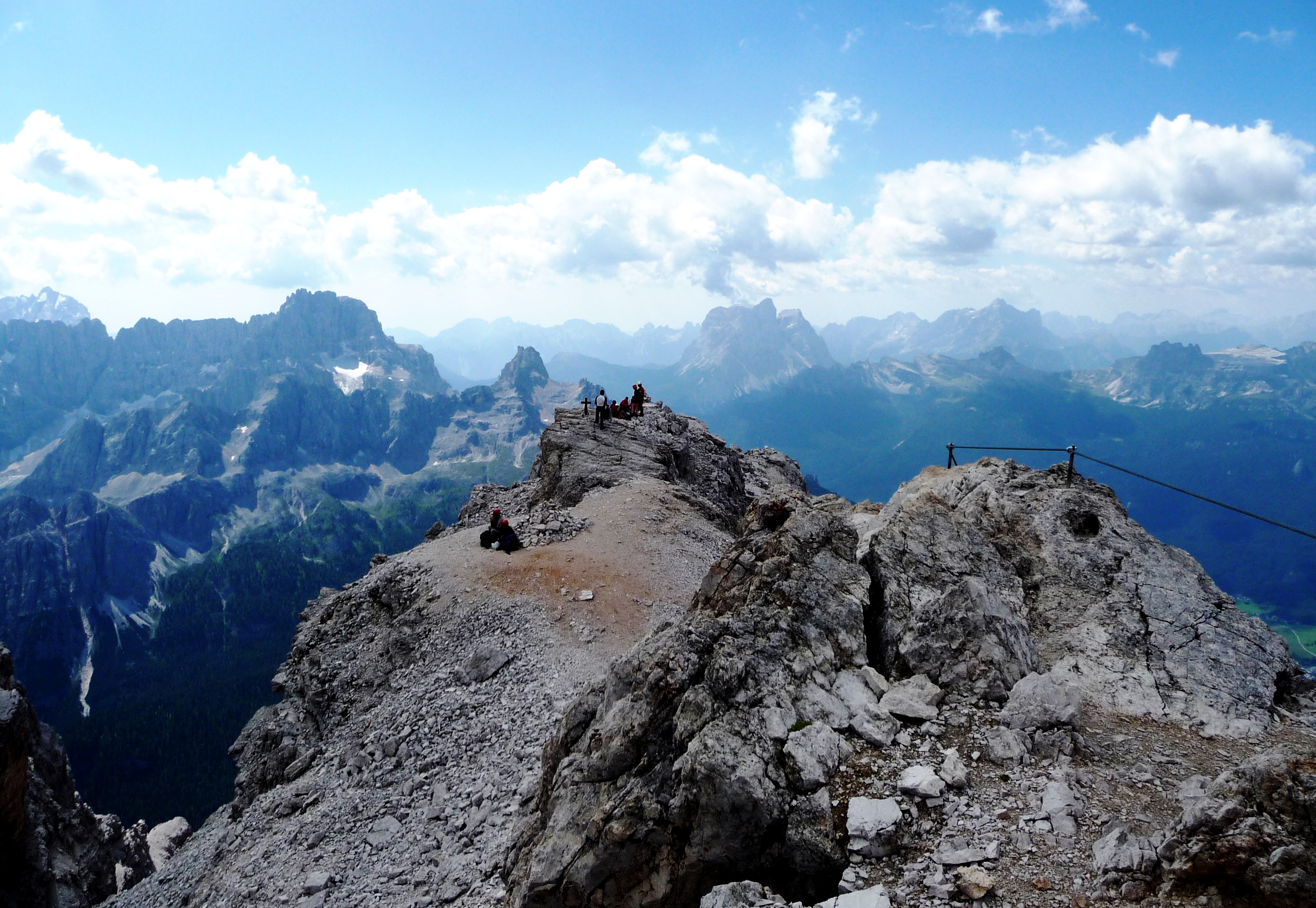
– la ferrata attacca direttamente dal Rifugio, sulla destra. Il primo tratto molto panoramico si sviluppa in cresta, dovendosi superare alcuni passaggi tecnici; tale tratto è “a doppio senso di marcia”, cioè la via di andata e di ritorno è la medesima;
-il secondo tratto si svolge superando un paio di paretine e così l’ultima torre, finalmente giungendo in quota e, poco dopo, al terrazzo di vetta;
-tale secondo tratto nel ritorno ha oggi un doppio percorso, poiché una volta arrivati sul terrazzo di vetta, si può andare a destra con sentiero in discesa piuttosto esposto (da non fare con neve o ghiaccio) che costeggia l’ultima torre;
– si riprende la via della prima parte e si giunge poi al Lorenzi;
– la discesa può:
i) portare direttamente a Rio Gere;
ii) portare a Son Forca e quindi in Val Padeon e dunque ad Ospitale (vedere gita relativa).
Valutazioni: E’ molto panoramica ed acquista 200 m. di dislivello in cresta sul Cristallo, giungendo alla vetta in circa 1,5 h (stesso tempo per il ritorno) – La non eccessiva lunghezza della ferrata e il suo non semplice tracciato nonché la sua grande spettacolarità, offrono un mix che porta l’appassionato a farla più volte. Per l’altitudine va effettuata con tempo bello e certo; necessita di un po’ di esperienza ed ha alcuni passaggi per cui serve buona tecnica per coprire il dislivello relativo – Poiché, come detto, la prima parte è a “doppio senso di marcia”, e poiché è ferrata di altitudine (tutta oltre i 3.000 metri), è opportuno partire il più presto possibile, per trovare gente solo al ritorno (il che può ritardare la marcia) e tempo migliore e più stabile. Il ritorno su Ospitale implica un’organizzazione preventiva delle automobili appunto ad Ospitale, essendo partiti da Rio Gere [effettuata i) 16.8.81; 17.8.83; 10.8.85; 10.8.88; 16.8.94; 5.8.95; ii) 20.8.11].
From Rio Gere, the Rif. Son Forca and the Rif. Lorenzi (ascent by chairlift; strong weather phenomena in August 2017 stopped the second part of chairlift -Son Forca / Lorenzi- that is closed; it is therefore necessary to get on foot from Son Forca (2,216 m above sea level) to the Lorenzi Refuge (2.932 m above sea level) on a steep path on a scree; today there are variants to attack the lower level path; acquire information on accessibility and on the state of the paths;- The “ferrata” attacks directly from the Refuge, on the right. The first very scenic stretch develops ridge, having to overcome some technical steps; this portion is “on two-way traffic”, that is, the way of forward and return is the same; -The second section takes place by passing a pair of partition walls and so the last tower, finally arriving at altitude and, shortly after, to the summit terrace; -This second stretch in the back has a dual path today because once you get on the top terrace, you can go right with downhill path rather exposed (not to do with snow or ice) that runs along the last tower; – It takes the way of the first part and then reach the Lorenzi;- The descent can: i) lead directly to Rio Gere; ii) lead to Son Forca and then in Val Padeon and thus to Hospitable (see related trip). Ratings: It ‘very scenic and acquires 200 m. of altitude on the ridge on the Crystal, reaching the summit in about 1.5 h (the same time for the return) – The non-excessive length of the railway and its not easy to track as well as its highly spectacular, offering a mix that brings the enthusiast to make her more times. For the altitude must be done with beautiful and some time; needs a little ‘experience and has some passages for which serves good technique to cover the relative height difference – Since, as said, the first part is to “two-way traffic”, and since it is climbing in altitude (all above 3,000 meters), you should leave as soon as possible, to find people just to return (which may delay the march) and better and more stable weather. The return of Hospitable implies preventive organization of the cars precisely to Hospitable, having started from Rio Gere [performed i) 16.08.81; 08/17/83; 08/10/85; 10/08/88; 16/08/94; 05/08/95; ii) 20/08/11]
§ § §
Area: Cristallo / Carbonin – Val Fonda – [a) 1/2 giornata – gita per tutti – un’ora circa – b) intera giornata – gita per tutti ma su tracce di sentiero– tre/quattro ore circa]
Percorso:
-in automobile per la strada verso Dobbiaco, dopo Carbonin, girare a destra per Misurina; dopo poco si raggiunge il Ponte della Marogna ove si parcheggia;
A) seguendo nella primissima parte il Rio Val Fonda, sulla sinistra si dipartono tracce di sentiero che portano nel bosco; qui si incontrano, inaspettate, delle trincee e una lapide della 6° Compagnia alpini.
Valutazione: Una bella salita nel bosco (circa 100 m. di dislivello) per vedere vestigia poco conosciute di una delle tante battaglie sul Cristallo [effettuata 10.8.95]; la salita per la val Fonda ha il pregio di essere poco frequentata seppur all’ombra, essendo una valle piuttosto chiusa.
-path: in car after Carbonin, turn right to Misurina; will shortly arrive at the Marogna Bridge where you park; – Following in the very first part of the Rio Val Fonda, the left branch of trail tracks leading into the woods; They meet here, unexpected, trenches and a plaque of the 6th Alpine Society. Rating: A beautiful hill in the woods (about 100 m. In altitude) to see little-known vestiges of one of the many battles on Crystal [carried 10/08/95].
B) seguendo nella primissima parte il Rio Val Fonda (m. 1598 s.l.m.) si individuano tracce di sentiero che portano nella stretta valle che si incunea nel Circo del Cristallo, un anfiteatro formato dal Cristallino di Misurina e dal Piz. Popena ove c’è l’ultimo esempio del ghiacciaio del Cristallo (ormai quasi scomparso). Si segue il corso del torrente Marogna, che è carsico, ed ogni tanto emerge (anzi ultimamente l’acqua è abbondante ed è sempre visibile); si attraversa -sempre camminando sul greto ampio- un vero e proprio canyon largo con alte pareti scoscese di grande impatto visivo; poi la valle sale e si prosegue sempre in alveo seguendo gli ometti in sassi che indicano la via (il vecchio sentiero al lato dell’alveo è franato); così -quando possibile se non c’è troppa acqua che rende difficile i continui guadi del torrente- si sale e ci si arrampica fino a dove possibile … (noi si è giunti anche all’altezza m. 1800 circa) – il ritorno è per lo stesso sentiero.
Valutazioni: La passeggiata ha il pregio di entrare in una valle non frequentata, selvaggia e incontaminata; splendido canyon; valle stretta e poco comoda per passeggiare poichè per lo più sempre in alveo; panorama bello ma che rimane il medesimo; da non effettuare in giornate di pioggia per pericolo di piene – non ci sono punti di ristoro neppure in partenza – [effettuata 11.4.84; 16.8.19; 16.8.21].
Area : Crystal / Carbonin – Val Fonda – [ whole day – trip for all – three / four hours about ] – Path: – By car after Carbonin , take the road to the right to Misurina ; after a while you reach the bridge Marogna where you park ; – Following in the very first part of the Rio Val Fonda are identified traces of the path leading into the narrow valley that is wedged in the Circus of Crystal, an amphitheater formed by Crystalline Misurina and Piz. Popena where there is the latest example of the glacier Crystal (now almost disappeared). Follow the course of the Marogna stream, which is karst, and occasionally emerges (indeed lately the water is abundant and is always visible); you cross – always walking on the wide shore – a real wide canyon with high steep walls of great visual impact; then the valley rises and continues along the riverbed following the stone cairns that indicate the way (the old path beside the riverbed has collapsed); so – when possible if there is not too much water that makes the continuous fords of the stream difficult – you go up and climb up to where possible … (we have also reached the height of about 1800 m) – the return it’s on the same path.
Evaluations: The walk has the advantage of entering an uncrowded, wild and uncontaminated valley; beautiful canyon; narrow valley and not very comfortable for walking as it is mostly always in the riverbed; beautiful landscape but which remains the same; not to be carried out on rainy days due to the danger of flooding – there are no refreshment points even at the start [carried out 11.4.84;16.16.19; 16.8.21]. ° ° °
Area: Cristallo / Carbonin / Tre Croci – Val Popena – [intera giornata – gita per tutti la alta per più esperti la salita ai ruderi del vecchio rifugio Popena – tre /cinque ore circa]
i) per la Val Popena è consigliata con partenza dal ponte di Val Popena; da Cortina in automobile (strada Alemagna) dopo Carbonin, a destra per Misurina; dopo qualche chilometro (in cui si percorre quella che comunemente si chiama Val Popena bassa), si ferma l’automobile al Ponte di Val Popena che porta alla Val Popena alta (partenza migliore per il percorso 2)
i) per Rudevoi fino ai ruderi del rifugio di Val Popena alta – è consigliata la partenza dal parcheggio sulla sinistra (venendo da Cortina – Tre Croci) dopo il ponte moderno (de Rudavoi) che supera il rio Popena (partenza migliore per il percorso 1);
Ruderi rifugio Popena :
– dal parcheggio (1703 m. slm) si sale fino alla Forcella Popena (2214 m. slm) – Il sentiero 222 è ben segnato; – la prima parte nel bosco (per la Val Oriè) area Rudevoi prende quota piuttosto velocemente, ma il sentiero è spesso bagnato e se è piovuto da poco, si trasforma in piccoli rigagnoli; serve passo fermo in tale ipotesi; – la seconda parte è in quota nel bosco, molto piacevole, fino al bivio di Valoriè (1956 m. slm), con il sentiero 224; – quindi il sentiero 222 sale ancora rapidamente tra ghiaie e mughi, fino ad una mugaia in dolce salita; – l’ultima parte del sentiero attraversa in quota un ghiaione ma intercetta una importante frana che va prima attraversata (con perizia ed attenzione) e quindi costeggiata in ripida salita (per cui serve passo fermo ed assenza di vertigini); prosegue poi con terrazzamenti, ponti e scale attrezzate di recente ed in perfetto stato pur se esposti in alcuni punti (agosto 2021) che portano alla forcella; forse questi ausili servirebbero anche nella parte della frana poco prima; -si giunge infine in forcella Popena dove ci sono i ruderi del Rif. Popena, ancora ricchi di fascino;
– la discesa è per il medesimo sentiero ma allo stato è certo più agevole proseguire per il sent. 222 (il 224B è al momento inagibile) che scende nella Val Popena; dopo una decina di minuti di discesa sulla destra si diparte una traccia di sentiero ben segnata che rimane (pur con alcuni saliscendi) in quota a metà del costone delle pale di Misurina giungendo, con uno strappo finale, alla forcella sopra il lago di Misurina (2138 m. slm); – da qui la discesa ripida, molto panoramica ma con sentiero comodo, porta alla Malga Misurina (1795 m. slm) ed al lago.
Val Popena bassa 
il sentiero parte dalla strada; sent. 222 (= Sentiero Italia e A.V. n. 3; m. 1659 s.l.m.), che sale prima seguendo il greto del torrente Popena, e poi nel greto del torrente; forse un pò lungo e noioso, perchè non comodissimo per il trekking; in ogni caso il sentiero sul greto asciutto del fiume (sempre più lungo, per le frane dal 2017 ad oggi) termina con una biforcazione che sfugge ai più (dopo circa 1 h);
a sin. -proseguendo sul greto- con pochi passi si giunge ad una grande radura verde (ove è piacevole riposare); salendo poi per bosco e tracce di sentiero si incrocia sentiero in costa che porta alla forcella Popena (fin qui il 23.8.16); a des. si prende un sentiero nel verde e che presto sale nel bosco piuttosto fortemente per alcuni minuti per giungere ad un altipiano aperto (panorama bellissimo e solitario; avvistata famiglia di aquile 2 grandi e 2 piccoli nell’agosto 2015; m. 2069 s.l.m.) ove si apre una doppia possibilità:
 a) si prosegue sul medesimo sentiero n. 222, salendo nell’anfiteatro –con a destra il Cristallino di Misurina ed a sinistra il Monte Popena e le Pale di Misurina- fino alla Forcella Popena (circa 500 m. di dislivello; 1,5 h) per boschi e poi su roccia, con una salita più dura nell’ultima parte;
-si giunge così (per una via più facile rispetto alla gita 1) in forcella Popena dove ci sono i ruderi del Rif. Popena, ancora ricchi di fascino;
-la discesa è per il medesimo sentiero ovvero, proseguendo, verso la strada Cimabanche – Misurina.
b) si prende sentiero verso sinistra che prima in quota poi salendo in direzione delle Pale di Misurina, porta alla forcella (dopo circa 45 min. e circa 180 m. di dislivello; m. 2140 s.l.m.) con un panorama magnifico sul lago di Misurina e sui Cadini di fronte;
-la discesa sul lago segue il medesimo sentiero 224 (20 min.).
Valutazione: le gite non hanno rifugi e dunque serve acqua e viveri – 1- Val Popena bassa: Una bella salita nel bosco per giungere in una valle molto bella ed ancora incontaminata, costeggiando (nel versante Carbonin) il torrente e giungendo ai ruderi del rifugio; il catino in cui ci si trova immersi è spettacolare e poco frequentato rispetto all’area in cui è immerso; la sella a picco su Misurina presenta un panorama mozzafiato sulle Tre Cime e sui Cadini; durata 2,5h/3; [effettuata 26.8.12; 21.8.15; parziale il 23.8.16; il 18.8.17]. – 2 Val Popena alta: salita panoramica anche se più faticosa (si vedano le osservazioni nel testo) e per esperti; durata due ore alla sella; due ore poi fino a Misurina; [effettuata: 10.8.95, con sentiero in altre condizioni; la descrizione è aggiornata al 17.8.21]
Area : Crystal / Carbonin / Tre Coci – Cima Popena – whole day – trip for all – 3-5 hours ]
i) for the lower Val Popena it is recommended starting from the Val Popena bridge; from Cortina by car (Alemagna road) after Carbonin, right for Misurina; after a few kilometers, the car stops at the Ponte di Val Popena Alta (best start for route 2) i) for the upper Val Popena it is recommended to leave from the car park on the left (coming from Cortina – Tre Croci) after the modern bridge that crosses the Rio Popena (best start for route 1);
Val Popena Alta: – from the car park go up to the Forcella Popena (de Rudavoi) The path 222 is well marked; – the first part in the woods gains altitude rather quickly, but the path is often wet and if it has recently rained, it turns into small rivulets; we need a firm step in this hypothesis; – the second part is at high altitude in the woods, very pleasant, up to the junction of Valoriè (1956 m. asl), with the path 224; – then the path 222 still climbs rapidly among gravels and pines, up to a mugaia in gentle ascent; – the last part of the path crosses a scree at high altitude but intercepts an important landslide that must first be crossed (with skill and attention) and then flanked in a steep climb (for which you need a steady step and absence of dizziness); it then continues with terraces, bridges and stairs recently equipped and in perfect condition even if exposed in some points (August 2021) that lead to the saddle; perhaps these aids would also be useful in the part of the landslide shortly before; – finally you reach the saddle where there are the ruins of the Rif. Popena, still full of charm; – the descent is along the same path but at present it is certainly easier to continue along the path. 222 (the 224B is currently uninhabitable) which descends into the Val Popena; after about ten minutes of descent on the right, a well-marked trail departs which remains (albeit with some ups and downs) at an altitude in the middle of the Popena ridge reaching, with a final stretch, the saddle above Lake Misurina; – from here the steep descent, very panoramic but with an easy path, leads to Malga Misurina and to the lake
Val popena bassa: takes the path n. 222 ( = Path Italy and AV n . 3), and go up following the river Popena; reached a large clearing ( after 1 h ) continue with the path on the right that goes quite strongly for a few minutes to reach a plateau open ( beautiful landscape and solitary family of eagles spotted 2 large and 2 small in August 2015) – opens a double chance: a) continue on the same path no. 222, climbing -with the right Crystalline Misurina and left Mount Popena and the Pale of Misurina- to Forcella Popena (500 m. In altitude, 1.5 h) – Forest and then on the rock, with a climb more hard in the last part; -it comes at the Forcella (=fork; pass) where there are the ruins of the Rif. Popena, still full of charm; -the descent is the same path that, continuing toward the Passo tre Croci (cfr. 1 path) b) turn to the left going towards Pale Misurina, taking the variant of the felt. 224; – You reach the fork (after about 45 min. And 180 m. In altitude) with a magnificent view of Lake Misurina and the Cadini opposite; -the descent of the lake follows the same path 224 (45 min.).
Rating: Evaluation: 1- Lower Val Popena: A nice climb in the woods to reach a very beautiful and still uncontaminated valley, skirting the stream (on the Carbonin side) and reaching the ruins of the refuge; the basin in which you are immersed is spectacular and not very crowded compared to the area in which it is immersed; the saddle overlooking Misurina offers a breathtaking view of the Tre Cime and Cadini; duration 2.5h / 3; [carried out 26.8.12; 21.8.15; partial on 23.8.16; on 18.8.17]. – 2 Val Popena high: panoramic climb even if more tiring (see the comments in the text) and for experts; duration two hours at the saddle; two hours then up to Misurina; [carried out: 10.8.95, with the path in other conditions; the description is updated on 17.8.21]